Strong west swells from tomorrow
Wednesday, 16 July 2025
Strong west swells from tomorrow
Wednesday, 16 July 2025
We've got tons of energy inbound but it'll all be west.
We've got tons of energy inbound but it'll all be west.
This won’t be well placed for CQ but we may see a rideable day as the low drifts away towards New Caledonia.
Metro locations will be the pick this period with persistent onshore breezes to the south.
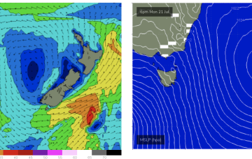
Tiny into tomorrow before a small kick in E/SE swell Fri from the low SE of the South Island which is currently on the edge of the swell window.
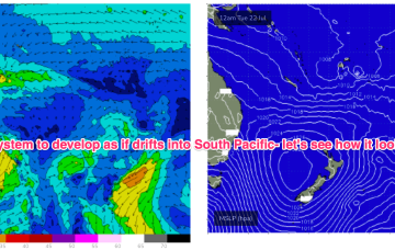
We'll see plenty of surf surf from this system initially but there is broad model agreement we’ll see this low deepen and develop into a more powerful system mid/late next week as it drifts into a position north of the North Island. Best case scenario is a quality E’ly groundswell event from this system.
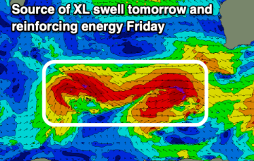
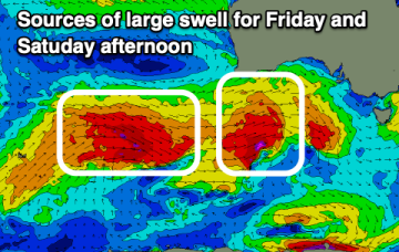
We've got back to back large swells inbound as winds mostly favour the South Coast.
Not much short term gain from this system but there is broad model agreement we’ll see this low deepen and develop into a more powerful system mid/late next week as it drifts into a position north of the North Island.
Multiple pulses of large swell are inbound, with favourable winds for the Surf Coast.
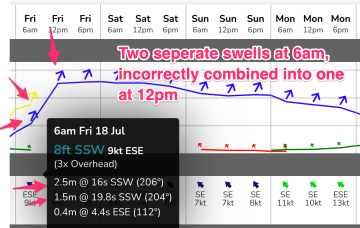
The models are mixing swells and over-forecasting the incoming swell energy. Read more for the run down.
A strong front pushed into off the NSW coast the Tasman Sea overnight, and it’s generating a flush of south swell that’ll fill in this evening and provide a nice boost in surf size across Northern NSW on Tuesday.