Strong west swells from tomorrow

Southern Tasmanian Forecast by Craig Brokensha (issued Wednesday July 16th)
Best Days: Every day this period
Features of the Forecast (tl;dr)
- Moderate sized W/SW groundswell for tomorrow AM, easing, with a secondary similar, inconsistent pulse for Fri, easing later
- Third pulse of smaller, reinforcing W'ly groundswell Sat PM, easing Sun
- Early strong N/NE tending N/NE then W/NW winds
- Persistent N/NW-NW winds Fri
- Strong N-N/NE tending N/NW winds Sat
- Smaller Sun with strong N/NW-NW tending W winds Sun
- Smaller Mon with N winds
Recap
Monday’s swell eased back from a fun 2-3ft yesterday with today still coming in at 2ft with light winds all day.
This week and weekend (Jul 17 - 20)
From tomorrow we should see our first pulse of inconsistent W/SW groundswell filling in across the region, followed by further pulses of less ideally aimed swell Friday and Saturday afternoon.
The source of these swells is a stream of strong storms moving in from the Heard Island region initially and then under Western Australia secondarily.
The best swell producer for tomorrow was positioned a little further south with a fetch of severe-gale W/SW winds expected to generate 3ft+ of surf tomorrow morning, easing a little into the afternoon.
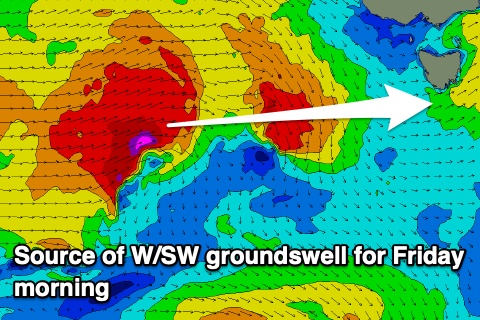
Moving into Friday, and our secondary pulse of W/SW groundswell is due, with a more northerly located frontal system passing under WA due to generate a secondary fetch of severe-gale W/SW winds today while projecting east.
Another 3ft+ swell is expected, with it easing into the afternoon, smaller and to 2-3ft on Saturday.
The easing trend Saturday afternoon will be halted by the arrival of a third and final pulse of less favourable W’ly groundswell. This looks to be generated by a final front positioned a touch further north again, generating severe-gale W/NW winds through our western swell window.
Inconsistent 2-3ft sets are due all day Saturday before easing from 2ft Sunday.
Local winds will swing from N/NE early tomorrow around to the N/NW then W/NW through the day, with persistent N/NW-NW winds Friday. Strong N-N/NE tending N/NW winds are then due Saturday with strong N/NW-NW tending W winds Sunday.
There might be one final pulse of W’ly swell Monday by a south-east dipping low to our west on Sunday but we’ll have a closer look at this Friday. Regardless only 2ft or swell is due, smaller for the rest of the week.