Onshore winds continue until Thursday

Western Australian Surf Forecast by Craig Brokensha (issued Monday September 4th)
Best Days: Late Wednesday protected spots, Thursday, Friday for the desperate in the South West
Features of the Forecast (tl;dr)
- Large, easing SW swell tomorrow with strengthening W/NW winds, smaller Wed with strong but easing S/SW winds, tending S later
- Moderate sized, easing SW swell Thu with fresh E/NE tending weaker N/NE winds
- Smaller Fri with strong E/NE winds
- Small Sat with N/NE winds
- New small SW swell Sun with freshening W winds
- Large surf developing through mid-late next week with W/NW winds
Recap
Poor surf on the weekend across all locations with a strengthening onshore wind Saturday and moderate-large sized swell, much larger through yesterday with stormy conditions developing.
Today the onshore winds are still wreaking havoc with oversized surf persisting in the South West, junky and smaller to the north.
This week and weekend (Sep 5 - 10)
The coming forecast period mostly revolves around when we're expected to see winds swing offshore and it looks to be later in the week, on the backside of the current large, stormy swell event.
Today's oversized groundswell was generated by a strong frontal system that fired up west of the Heard Island region late last week. The secondary system pushing up and into us yesterday and today wasn't quite as strong as forecast last week but it's still maintaining the expected 10-12ft waves in the South West, 4ft across Mandurah and 3ft+ in Perth.
We're due to see this swell easing into tomorrow, further Wednesday but with persistent onshore winds thanks to a strengthening mid-latitude front pushing up and across us.
This will bring strengthening W/NW winds tomorrow, shifting S/SW on Wednesday morning and holding most of the day ahead of a late shift to the S'th.
Thursday finally looks cleaner as high pressure moves in, swinging winds E/NE and then N/NE through the day across the South West along with easing 5-6ft sets on the magnets, 2ft Mandurah and 1-2ft Perth.
Friday will become smaller again along with strong E/NE winds.
The strengthening winds will associated with a broad low forming to our west, squeezed by approaching frontal activity across the Heard Island region.
Winds are due to dip N/NE on Saturday as the low moves east, then onshore from the W Sunday as a small pulse of new mid-period SW swell fills in.
No major size is expected and we then look to the swell expected off the frontal progression moving in behind the low.
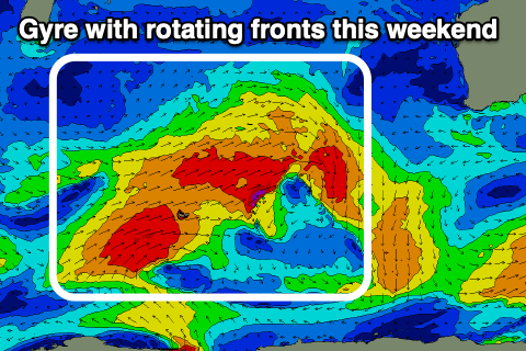
This looks to be quite a strong setup but the models are struggling to resolve the finer features, like the strength and longevity.
What we're looking at is a large gyre with multiple front spawning up and around it, projecting fairly northward into the Indian Ocean. This will generate a large run of W/SW groundswell through mid-late next week but with what looks to be onshore winds. We'll have a closer look at this on Wednesday.