Smaller cleaner waves ahead of large surf from late next week

Western Australia Surf Forecast by Craig Brokensha (issued Friday 24th May)
Best Days: Swell magnets in the South West every morning from tomorrow through Tuesday (all day Sunday and Monday), next weekend
Recap
Average easing surf from 6ft+ across the South West yesterday, better and clean to 2-3ft in Mandurah and 2ft in Perth.
This morning was smaller but still onshore across the South West, smaller and clean to 2ft on the sets around Mandurah and Perth.
Today’s Forecaster Notes are brought to you by Rip Curl
This weekend and next week (May 25 – 31)
Winds will finally swing offshore across the South West tomorrow morning and continue to improve towards midday. A light morning SE breeze should swing more E'ly later morning ahead of weak sea breezes, but the swell will be smaller and easing 4-5ft sets on the magnets. Perth will be tiny with possibly the odd stray 1-2ft set across Mandurah.
Sunday will be clean again with an E/SE offshore but with a leftover easing 3ft+ wave across South West swell magnets.
A new long-period SW groundswell should build into Sunday afternoon, generated the middle of this week by a strong but short-lived polar low. While inconsistent it should kick to 4-5ft later in the day as winds hold from the SE and likely hold 4-5ft+ Monday morning in the South West, easing into the afternoon. Mandurah may see 1-1.5ft sets but be mostly tiny, and winds Monday morning look great and offshore from the E/SE, persisting all day.
 Tuesday will be clean again but on the small side, back to 3ft+ and then easing from 3ft Wednesday as winds shift more E/NE-NE.
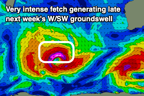
Of greater importance are the developments in the Indian Ocean from Sunday through next week.
As talked about the last couple of updates, a strong and intense low is forecast to develop just north of the Heard Island region Sunday evening under the influence of a strengthening and pronounced node of the Long Wave Trough.
The low will still have quite a meridional (north-south) direction, but as it initially forms a great fetch of gale to severe-gale and embedded storm-force W/SW winds will be aimed towards us, producing a large long-period W/SW groundswell for later Thursday and Friday morning.
The swell should kick to 6ft by dark on Thursday across the South West with 2ft sets in Mandurah and Perth but with average and strengthening N/NE winds.
 The swell is likely to peak Friday morning to 6-8ft and 2ft+ respectively but with a W/SW change as a trough moves through.
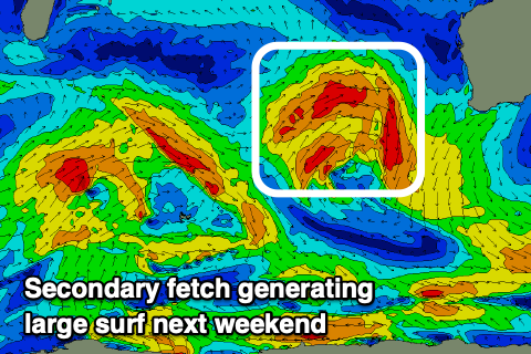
This change will be linked to the remnants of a secondary strong mid-latitude front spawning off the low and projecting a fetch of W/SW gales towards us through our western swell window. Latest model updates have a deep low pressure centre forming and a tighter storm-force W/SW fetch right off our coast before the system dips south-east on Friday.
Regardless of this a large W/SW groundswell will be produced by the front, building late Friday and peaking Saturday and coming in at this stage to 8-10ft (bigger if the low forms) in the South West, 3ft in Perth and Mandurah and with light offshore E/SE winds as a high slides in.
Winds look to quickly swing to the N/NE on Sunday as the swells ease, but we'll have to review this Monday. Longer term there are a few further pulses of smaller swell due next week, but more on this Monday. Have a great weekend!