Mediocre swells continue, best Sunday morning

Western Australia Surf Forecast by Craig Brokensha (issued Wednesday 10th February)
Best Days: Sunday morning, Monday morning, Tuesday morning
Recap
Bumpy waves holding in that 4ft range yesterday and today across the South West with a series of SW groundswell pulses, while further north the surf remained tiny for the most part but clean each morning.
This week and weekend (Feb 11 - 14)
Tomorrow we are expected to fall in between swells with 3ft to occasionally 4ft sets across the South West as SE winds persist.
A new kick in SW swell back to 3-4ft+ is due through Friday as another small SW groundswell pulse fills in but conditions will be average as a surface trough moves in from the west early bringing S/SW tending S/SE winds ahead of likely afternoon sea breezes.
 Saturday morning should see more of the same with SW swell pulsing between 3ft and 4ft, but into the afternoon and more so Sunday our better pulse of SW swell is looking good.
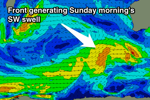
This swell will be generated by another relatively weak front pushing in from the west, but it will take a diversion and project north-east closer to us through the end of the week.
A good kick to 4-5ft is expected Sunday morning with fresh and gusty offshore E/SE offshores, tending S/SE into the afternoon.
Perth through this period isn't likely to top 0.5-1ft, biggest Sunday morning to 1-1.5ft.
Next week onwards (Feb 15 onwards)
Behind the frontal system generating Sunday's SW swell, secondary less favourably aligned activity should keep 3-4ft of SW swell hitting Margs through Monday and Tuesday, bottoming our Wednesday morning.
Offshores should persist Monday with strength through the morning, lighter Tuesday morning.
S'ly winds are then due to kick back in from Wednesday and a very strong but funky trough should deliver some good SW groundswell into the afternoon and Thursday.
This front will produce a very strong pre-frontal and poorly aligned severe-gale NW fetch, with post-frontal but weaker W/SW winds. The structure of this system is still moving around a bit so check back here Friday for an update.