Plenty of good surf days ahead

Victorian Surf Forecast by Ben Matson (issued Friday 8th September)
Features of the Forecast (tl;dr)
- Large storm swell building rapidly this afternoon, easing steadily through Saturday
- Improving conditions for Surf Coast and Western Port on Saturday as winds back to the W/NW
- OK conditions Surf Coast Sunday with small/mod steady swells
- Nice S/SW groundswell building Monday, easing Tuesday with good winds for most locations
- Smaller surf Wed/Thurs with light winds and fun beachies
Recap
Easing surf and freshening northerly winds on Thursday provided clean 2-3ft waves across the open beaches west of Melbourne and up to 4ft east of Melbourne. Size has held similar today with strengthening northerly winds ahead of gale to storm force W'ly tending SW winds as a deep low pressure system crosses Bass Strait. A large increase in local swell is expected in the wake of the low.
This weekend (Sep 9 - 10)
No changes for immediate outlook once winds swing onshore over the coming hours. We're looking at unusually large storm surf (8ft Surf Coast, 10ft MP/PI) by close of business today that will only favour a small number of sheltered spots.
The weekend outlook has one main trend for the swell (down) but a few interesting fluctuations in the wind department.
This afternoon's storm force onshore winds will slowly abate overnight, and by morning should be back around to the west, tending W/NW through the day (maybe even NW late afternoon). The reason for this is an approaching short wave feature (shallow front) that won't generate any new swell, but will contribute another wind change to the Victorian coast overnight on Saturday.
As such, Saturday's surf will certainly be improving from the expected mess due later today, but the swell lines will be raw and ragged to begin with - though it'll improve as the day wears on. Size will be easing steadily, potentially still a wobbly 6ft+ on the Surf Coast at dawn, but down to 3-4ft by mid-late afternoon. Local swell sources like this produce different responses across the reefs compared to the more classic long range groundswells, so be prepared for some variation.
East of Melbourne, the open beaches will be a mess so it's shaping up for a decent round of action across Western Port with improving winds and enough size to favour most breaks.
The overnight W/SW wind change on Saturday will persist east of Melbourne on Sunday, with smaller surf - too big for the open beaches (4-6ft) but probably a little undersized for Western Port, so surfing options look patchy here for the second half of the weekend.
However we should see local topographical effects steer Sunday's wind back around to the W/NW, west of Torquay. Again, there's likely to be some leftover surface wobble from the previous days of funky winds but conditions should certainly be quite OK, size is likely to level out in the 3ft+ range. Keep an eye out for a late swing in the wind to the SW as another weak short wave feature clips Tasmania and the Bass Strait waters (no major strength likely though).
Next week (Sep 11 onwards)
Light variable winds tending NW are expected throughout the first half of next week, which should create great conditions across the Surf Coast, and even allow for some options east of Melbourne too.
As for surf, we'll see a temporary low point at dawn on Monday, but over the following hours a new S/SW swell is expected to fill in, towards a broad peak in size from late afternoon through Tuesday.
This swell will have been generated by an interesting slow moving polar low currently skirting the ice shelf, which is expected to stall, broaden and intensify right on the eastern periphery of our swell window over the weekend (see below).
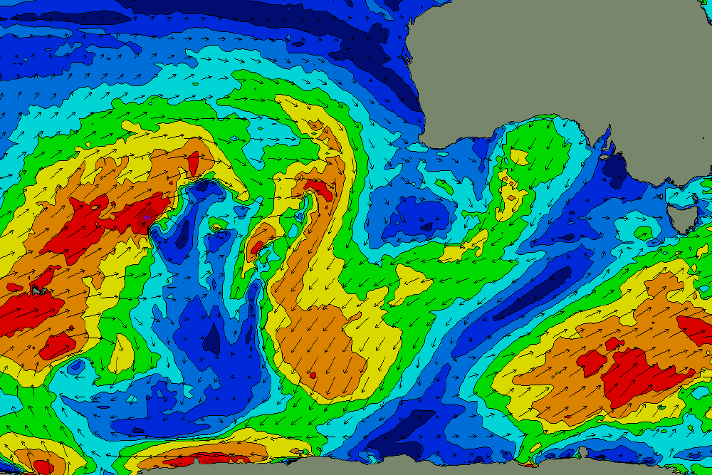
Nice fetch sitting below Tasmania on Sunday, that'll generate a decent S/SW swell for Mon/Tues
Swells from this source usually produce great results along the Surf Coast, owing to the more southerly direction, and at this stage we should see wave heights build into the 4-5ft range here, maybe the odd bigger set at the regional swell magnets. We'll see slightly bigger surf early of Melbourne with 5-6ft+ sets at exposed beaches.
Expect size to steadily ease from Tuesday afternoon into Wednesday, bottoming out Thursday with nice small options across the open beaches under the generally light wind regime.
Beyond this, the long range surf outlook is a little fragmented, with an initially quiet Southern Indian Ocean expected to fire up mid-next week, but with a northern storm track through the Bight, which suggests swells with a lot more west in them than is ideal.
Nevertheless, it's looking like yet another active run of fronts into nexy weekend and beyond, and once the storm track shifts into a more favourable part of Victoria's swell window, we'll see much more size potential throughout the state (i.e. during the following week).
More on this in Monday's update. Have a great weekend!
Comments
Tazzie going to get a battering Fri 15th/Sat 16th