Lots of swells inbound with generally favourable winds

Victorian Surf Forecast by Craig Brokensha (issued Wednesday 16th August)
Best Days: This morning on the magnets, tomorrow, Saturday, Sunday, Monday, Tuesday, Wednesday morning, Thursday (basically all days besides Friday)
Features of the Forecast (tl;dr)
- Moderate sized, inconsistent W/SW groundswell for tomorrow (possibly a touch undersized early) with fresh to strong N winds (N/NW to the west at times and N/NE to the east at times)
- Easing swell Fri, with some mid-period W/SW energy for the PM
- Strong SW winds moving in just after dawn Fri, tending W/SW through the day (early window of W/NW winds Surf Coast)
- Mod-large mix of W/SW swells for Sat with fresh W/NW-W winds
- Slowly easing swell Sun with moderate W/NW winds
- Moderate sized, mid-period W/SW swell Mon with fresh N/NW winds
- Stronger W/SW groundswell Tue with fresh W/NW winds
- Large W/SW-SW groundswell filling in Wed, peaking in the PM with gusty W/NW winds ahead of a PM S/SW change
- Easing swell Thu with N/NE winds
Recap
The Surf Coast was the pick yesterday with clean conditions and easing surf from the 3ft range, while a reinforcing SW groundswell for the afternoon maintained 2-3ft sets, easing from a slower but similar size this morning.
To the east the Mornington Peninsula was bumpy with cleaner, lumpy waves across Phillip Island. Today the exposed beaches are more so 3-4ft but with great conditions, easing through the day.

Clean peaks this morning
This week and next (Aug 17 - 25)
Following the easing trend seen since the weekend, we've got a new, inconsistent long-range W/SW groundswell due tomorrow across the state, generated by a strong but distant polar frontal progression that pushed through the Southern Ocean, between South Africa and Western Australia late last week and through the weekend.
It'll be inconsistent but we should see 3ft sets across the Surf Coast (possibly a touch undersized early) and 4-5ft+ sets to the east along with fresh to strong N'ly winds that look to tend N/NE at times to the east through the day and N/NW to the west.
This will provide options all over all day.
The swell should start to ease into Friday from an inconsistent 2-3ft and 4-5ft respectively, though the size doesn't look to shift too much through the day as some background, reinforcing W/SW swell energy arrives into the afternoon.
The window for clean conditions looks slim Friday as a front clips us, bringing a strong SW change shortly after dawn. There's a window of early W/NW winds due on the Surf Coast but it's not worth chasing.
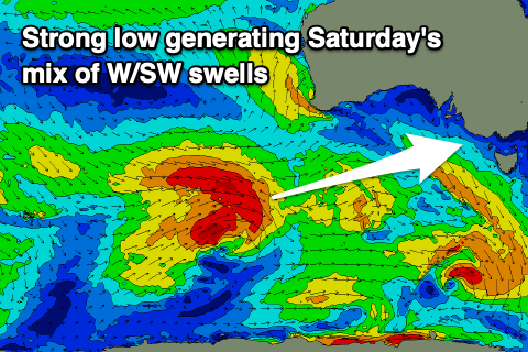
Friday's front will spawn off a strong low that's expected to generate a moderate to large pulse of W/SW groundswell for Saturday, with it forming east of the Heard Island region yesterday evening.
The low will generate a persistent fetch of gales, weakening temporarily south of Western Australia today before strengthening again slightly south of the Bight, though being tighter and smaller in nature.
This looks to result in a mix of mid-period and groundswell energy for Saturday, peaking to 4-5ft+ across the Surf Coast (6ft bombs on the magnets) and 6ft to occasionally 8ft to the east and with favourable W/NW-W winds that look to persist all day.
The favourable winds will be thanks to another frontal system approaching from the west, with it due to generate some reinforcing, moderate sized mid-period W/SW swell for Monday.
Sunday looks to offer slowly easing surf from the 4ft range on the Surf Coast, 6ft to the east and with moderate W/NW winds.
Monday's swell should come in at 3ft to occasionally 4ft on the Surf Coast, 5-6ft to the east as winds tend more N/NW ahead of further frontal activity moving in from across Western Australia.

From Tuesday we're looking at building levels of W/SW groundswell, likely peaking through Wednesday afternoon, generated by a strong, broad, polar frontal progression moving in from the Heard Island region later week.
We've got multiple fetches of gale-force winds acting on top of each other, producing a large W/SW-SW groundswell for Wednesday, with an initial moderate sized pulse of groundswell for Tuesday, generated by pre-frontal activity.
Winds at this stage look W/NW on Tuesday and Wednesday morning ahead of an afternoon S/SW change, possibly reverting back to the N/NE on Thursday as the swell starts to ease. We'll have a closer look at this again on Friday.
Comments
been the best winter for ages and it just keeps giving
hey craig, thanks! why is the automated forecast only calling 3ft and you're calling 4-5+? cheers!
The algorithm isn't working too well for the mix of swells for Saturday. It'll be bigger than the automated forecast.
you beauty cheers mate !!
Awesome , get some waves Sunday before the tillies play Spain !
RIP
Have to agree with PLStocks, best winter for ages. So many quality sessions the last few months on the beaches, reefs and points. Some of the bigger swells have been a bit uneven and bumpy at times, but that's me being fussy. The crowds have thinned out a fair bit too.