Make the most of the coming swells

Victorian Surf Forecast by Craig Brokensha (issued Monday 31st July)
Best Days: Today, tomorrow, Wednesday, Thursday for the keen exposed beaches in the morning, early Saturday for the keen
Features of the Forecast (tl;dr)
- Mod-large mix of swells for today with NW winds
- Larger spike of W/SW swell tomorrow with W/NW tending fresh SW winds early PM and then S/SW later
- Easing surf Wed with local offshore tending N/NE winds and freshening
- Smaller Thu with strong N winds, tending N/NW late PM
- Building inconsistent W/SW groundswell Fri with strong N/NW tending SW winds into the PM
- Close-range S/SW swell Sat with SW winds (W/NW early Surf Coast)
- Easing surf Sun with NW winds
Recap
Fun waves across the Surf Coast all weekend with a good pulse of mid-period S/SW swell for Saturday morning to 3ft+ on the magnets, easing through the day with a reinforcing W/SW swell providing 2-3ft waves into yesterday. To the east, selected locations were workable with periods of N'ly winds, biggest yesterday with the W/SW energy.
Today a moderate to large mix of mid-period W/SW swell is on the build with Cape Sorell showing some significant size, but the direction is west to even west-northwest, so it's not translating to as much size as you'd normally expect up in Bass Strait.
In saying this the Surf Coast is still a great 4ft+ with clean conditions, bigger to the east and with more to come as winds hold out of the NW (discussed below).
This week and weekend (Aug 1 - 6)
Today and the coming days will be worth making the most of before things go a little funky into the end of the week/weekend.
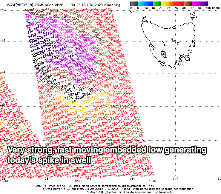
Currently a strong progression of frontal systems are moving through our western swell window, with persistent strong W/SW winds along with embedded lows that are generating tight gale to severe-gale fetches.
One of these moved through, just west of Tasmania early this morning (with storm-force barbs recorded) and this should boost the Surf Coast to a stronger 4-5ft through the day (looks to be there now) and 6ft to occasionally 8ft to the east as winds hold from the NW.
A larger pulse is now due tomorrow morning, generating by a tight but expanding front moving in today, generating severe-gale W/NW winds right west of Tasmania this afternoon.
Strong 6ft sets are due on the Surf Coast with 8ft+ waves to the east, easing later in the afternoon. Conditions will be best in protected spots with a morning W/NW breeze, shifting SW into the early afternoon and then S/SW later.
We've got our local offshore N'ly winds due on Wednesday with N/NE breezes to the east and N/NW winds to the west, shifting N/NE into the afternoon and freshening.
Size wise, the morning will still be solid for the exposed beaches to the east though maybe more accessible into the late afternoon.

We're looking at easing 4-5ft sets n the Surf Coast with 6ft+ sets to the east, smaller and to 3-4ft and 5-6ft respectively into the afternoon.
Thursday will become smaller and strengthening N'ly winds will create tricky but workable options to the east before shifting N/NW late afternoon.
This will linked to the remnants of a significant storm pushing in through the Bight and moving across us as a trough on Friday. There looks to be a window ahead of the change along with the arrival of the swell generated by the earlier stages of the low, that being between Heard Island and Western Australia today.
As touched in Friday's update, its structure isn't ideal for swell production for us with it being aligned more south to north and aimed into Indonesia, but with wind speeds of severe-gale to storm-force S/SW winds, weakening while aiming more SW and into our swell window, we should see a moderate sized W/SW groundswell building Friday, peaking into the afternoon and easing Saturday.
Building surf to 2-3ft is due Friday afternoon, smaller in the morning with N/NW winds, and then onshore out of the SW into the afternoon when the swell shows any size.
Saturday might see a more localised S/SW swell from the trough moving across us to 3-4ft on the Surf Coast and 5-6ft to the east but with SW winds (W/NW for a period in the morning to the west).
Sunday looks cleaner with a NW offshore but with smaller, easing surf from Saturday.
Longer term the outlook is a bit hit and miss with no reliable swell generating systems showing on the charts going with the ever reliable EC weather model forecasts, while GFS indicates a large new swell for early next week. Taking this with a pinch of salt, it's well worth making the most of the current swells and conditions.
Comments
Fingers crossed for better winds on Saturday for my schedule. Though I notice Mondays wind forecast for weekend is normally inaccurate compared to Willy weather and others for example. Is the team aware of this , any plans to address? I do note Wednesday forecast is normally more in line with the more accurate forecasts I see.
That's because Willyweather uses GFS, and I use EC for my forecasts, which is much more reliable over time if you keep track.
Thanks for response !. Am I seeing this period ( 5 days out) being pretty flukey from this far out anyway. And EC being a very dynamic ( closer to real time forecast adjustments happening throughout day). ?
Agh I see you're talking about the automated forecast.
We're aware of the differences in model output across various sites - one of which has easterly winds for Saturday morning - and have a new update coming soon that should improve things. However, the FC Notes are always your best source.
Always love your notes Craig - legend!
In particular, it's so helpful when you describe how consistent a swell will be. It's hard to get any gauge of consistency when looking at the automated forecast. Do you think a consistency rating will ever be added into the automated forecast as a feature?
Genuine question, does the predicted consistency of a swell determine where and when you surf?
I like to surf a certain spot when I know there’s gonna be 20min waits.
So the crowd on the hill think it’s flat???
a lil in jest.
It does for me on the surf coast in terms of where. When an inconsistent swell, there's some definite no's when it comes to spot selection. They seem to miss sets at the best of times as is...
Interesting…
yep,,.. i normally hunt plenty of forecasting sites automated and not,,,,,i only rest when I see one that says offshore.,,,,,cause that one has to be right i reckon when planning weekend and I'll hear nothing different. Even after I get skunked.
my analysis probably based around wishing for repeat saturdays rather than any real science, i thought it was Gold !!....logie level.....for weekend warrior anyway.
I’m sure the really knowledgeable folk here will add to and correct this, but here goes:
Assuming there is only one swell in the water, theory says that the time between sets should be longer during swells generated by distant fetches. Let’s consider a stationary fetch. The longest period energy travels the fastest and the further the sets have to travel from fetch to beach, the larger the gaps (longer lulls) between them by the time they reach their destination.
When there is more than one swell in the water, the overall picture is roughly the sum of the individual parts.
It’s also worth thinking about the evolution and movement of swell generating systems. If a fetch fires up and maintains strength while moving towards the coast for a while, then the sets it generates will be more closely spaced when they arrive at the beach. There is an analogy here with the pitch change of passing cars while waiting to cross a road or the blue shift in astronomy.
Taking this to an extreme, a fetch may even move at the same speed as the swell it generates for quite some time. People use terms like dynamic fetch and captured fetch to describe this situation and it produces many interesting phenomena. Victoria’s Boxing Day swell from last year is an example seen by many. That fetch moved NE towards Vic from beneath the Bight. When the swell peaked, there seemed to be sets arriving almost non-stop. It was as if the energy of an entire 2-3 day swell event hit the coast in a single day.
Consistency is a somewhat subjective, I’m not as fit as I used to be, but then the water is cold at this time of year, haha. As a first approximation, I’d suggest just paying attention to how far each swell has to travel. I notice the lulls in swells generated under WA and anything from west of Perth is just too slow
Yep pretty much nailed it. One other factor is direction, with the angle of the coast compared to the incoming swells or shadowing headlands upstream affecting consistency.
The bigger the difference between the incoming swell angle and angle of the coast, the less consistent the swell will be.
How about just go surfing ?
Right now?