One fun window over the weekend; next week looks very active though tricky winds

Victorian Surf Forecast by Ben Matson (issued Friday 17th March)
Features of the Forecast (tl;dr)
- Fun open beaches on Saturday
- Average conditions Sun, but with a new swell building
- Strong surf early next week but with fresh S'ly winds Mon, tending E'ly Tues
- Another round of strong groundswell Thurs thru' Sat
Recap
Good 3-4ft waves were reported across the Surf Coast on Thursday, with clean conditions under a W/NW flow. Bigger surf was found to the east with sets around 6ft. Today is holding a similar size though the trend is expected to slowly ease (Cape Sorell buoy data shows we've slowly passed the swell peak). Winds are temporarily light on the Surf Coast but fresh SW along the Peninsula and Phillip Island.
This weekend (Mar 18 - 19)
A shallow front will approach Victoria tomorrow, swinging the wind to the north-east early, then briefly strengthening from the north during the middle of the day ahead of a late W'ly change.
Your best options for waves will be at the regional beachbreaks (the Surf Coast reefs won't really like this wind), however east of Melbourne may be a little overpowered at first with sets in the 3-5ft range, though it'll get better during the day as size throttles back.
West from Melbourne will be a better choice with the open beaches easing from 2-3ft. There should be good waves until about mid-afternoon at most spots.
Trailing SW winds in the wake of the front will create average surf conditions for Sunday, but we should see a steady improvement west from Melbourne with lighter winds by lunchtime.
The good news is that a steady conveyor-belt of fronts below the continent are generating a new round of groundswell that will build through the day - probably not from first light - and should manage 3-4ft sets late in the day across the TQ stretch. Hopefully winds will be light by this time to allow for a semi-wobbly arvo session.
East of Melbourne looks pretty uninspiring on Sunday, though we may have small options late arvo at sheltered spots once the new energy starts to kick in.
Next week (Mar 20 onwards)
Unfortunately, the peak swell energy from this system is due Monday, which will coincide with a steady onshore flow thanks to a high west of Tasmania and a front racing up the western boundary of the Tasman Sea.
The Surf Coast is looking at solid 4-5ft sets (occ pushing 6ft at the regional swell magnets) but you'll have to scout around the protected spots for the best waves. There's only a few locations east of Melbourne that'll handle the size and the southerly breeze on Monday.
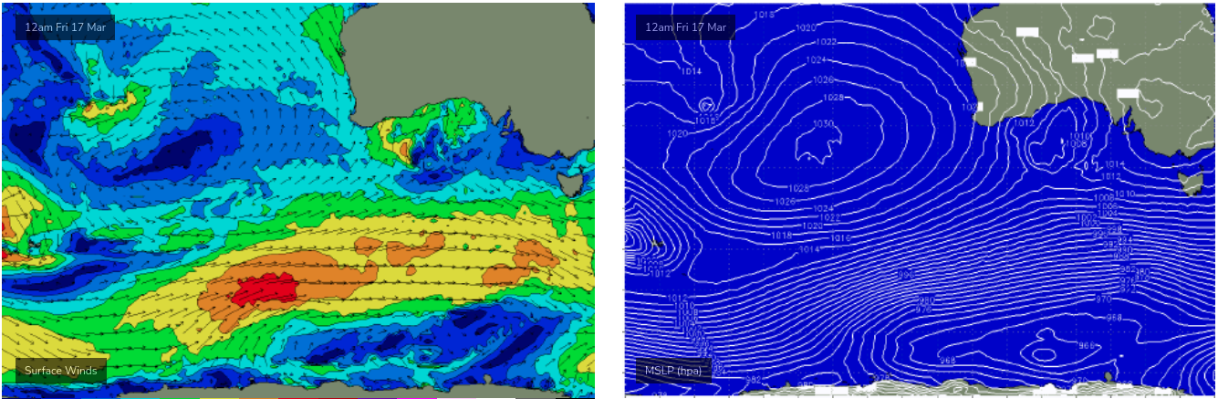
As the high moves in from the west into Tuesday, winds are likely to swing easterly - which is a terrible outlook for Torquay, and won't be able to be capitalised on at many spots east of Melbourne due to the persistent large wave heights. I'm a bit bummed about the local wind outlook for this time period as this swell generator looks unreal on paper (how's the slingshot fetch at the tail end of the frontal pasage, below!).
Fortunately, the long term outlook remains very active with another strong frontal conveyer belt lining up below the continent early next week that's expected to renew strong groundswells from Thursday thru' Sunday. It's too early to have confidence in the local winds but we're looking at a baseline of inconsistent 3-4ft surf in Torquay with embedded pulses pushing much higher than this at times.
I'll have more specific details available on Monday.
Have a great weekend!
Comments
Heads up, Bells car park now a construction site and heavily reduced parking availability.
That came around quick. Wonder who'll be the first pro to show up? Jack Robbo arrived very early last year and was putting in the time in some really shitty conditions when there was hardly anyone out.
Stay safe all....
"THE Department of Environment, Land, Water and Planning is recommending Eastern View and Memorial Arch residents evacuate due to a nearby bushfire and today’s extreme fire danger rating, while Lorne and Kennett River residents are advised to stay informed of under control bushfires."
https://timesnewsgroup.com.au/surfcoasttimes/news/eastern-view-and-memor...
these constant SE Autumn winds bringing back La Niña PTSD...
+1. Giving me the shits