Onshore change delayed, fun surf options through the week

Victorian Surf Forecast by Craig Brokensha (issued Monday 29th August)
Best Days: Today, tomorrow morning, Wednesday, Thursday, early Friday keen surfers in protected spots, exposed beaches next Tuesday
Features of the Forecast (tl;dr)
- Inconsistent, long-period W/SW groundswell arriving this afternoon, peaking overnight with fresh to strong N/NE-NE winds
- Easing groundswell tomorrow with strong N/NW-NW winds, easing and tending W/NW late morning ahead of a midday, strong SW change
- Smaller Wed withNW winds
- Inconsistent mid-period SW swell for late Wed, peaking Thu with N/NW-NW winds, tending S'ly late
- Moderate sized + SW swell Fri with mod-fresh SW winds (likely W'ly early Surf Coast)
- Slowly easing surf Sat/Sun with S/SW and S winds
- Moderate sized S/SW groundswell Mon with E/SE tending SE winds, easing Tue with NE winds
Recap
Great surf across most locations over the weekend with a reinforcing mid-period SW swell Saturday maintaining 3ft to occasionally 4ft waves on the Surf Coast (best on the beaches) with 4-6ft sets on the Mornington Peninsula, better into the afternoon as the swell eases.
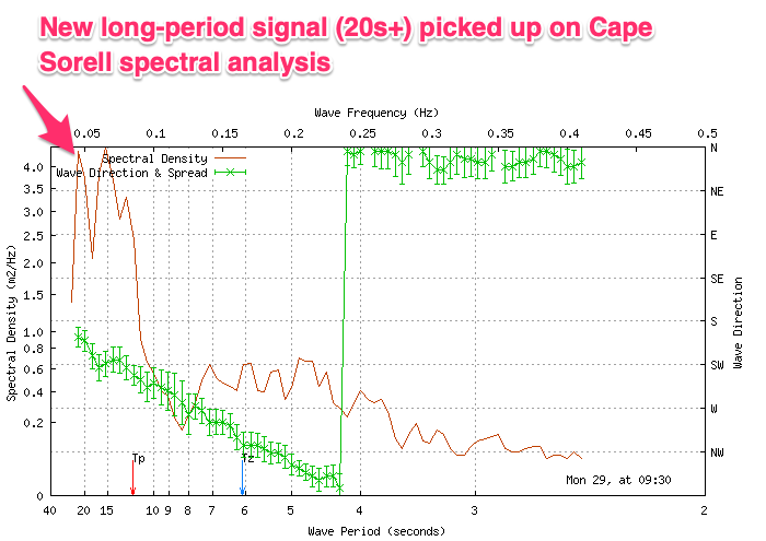
Yesterday was smaller and back to 2ft+ on the Surf Coast and 3-4ft to the east with great conditions for the exposed beaches. Today we've got a low point in swell this morning, but our new, inconsistent long-period W/SW groundswell is due to arrive later morning and build through this afternoon (it's just pinged on the Cape Sorell buoy).
Sets to 3-4ft are due on the Surf Coast magnets by dark, 6ft to the east as winds hold from the N/NE-NE (fresh to strong in strength).
This week and weekend (Aug 30 – Sep 4)
Looking at the outlook for tomorrow and the main real change are the local winds, with a trough that was expected to bring an onshore change into this evening now delayed until just after midday tomorrow. This is due to the trough forming into a little low, meandering its way slowly east today.
This will see favourable, strong N/NW-NW winds tomorrow morning, easing and tending W/NW later morning ahead of the strong SW change midday/early afternoon.
Swell wise, our inconsistent long-period W/SW groundswell due this afternoon and evening should start to ease tomorrow from a similar 3-4ft on the Surf Coast magnets and 6ft on the sets to the east.
Wednesday morning will see another low point in swell (2ft to occasionally 3ft Surf Coast magnets) and winds will quickly swing back to the NW, moderate in strength and then variable into the afternoon.
Later in the day we should see some new, inconsistent mid-period SW swell arriving, peaking Thursday ahead of a better pulse on Friday.
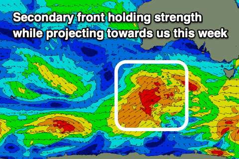
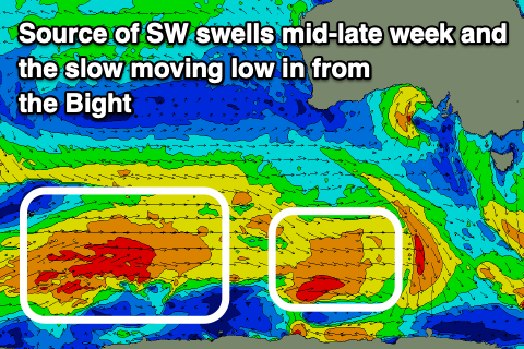 These swells have been and will continue to be generated persistent polar frontal activity around the Heard Island region and further to the east. Fetches of strong to sometimes gale-force W-W/SW winds are being generated, with an initial front generating later Wednesday and Thursday's swell while a secondary, front will hold its strength while projecting up towards us over the coming days. This will generate Friday's swell, with one final little low strengthening south-west of us Thursday due to generate a reinforcing pulse for Saturday.
The first pulse for later Wednesday and Thursday should come in at 3ft+ on the Surf Coast and 4-5ft+ to the east, with Friday's looking better and to 3-5ft and 6ft+ respectively.
 Winds on Thursday will remain favourable and from the N/NW-NW, giving into a late afternoon S'ly change as a trough moves in from the west, with Friday seeing SW winds unfortunately. There's a good chance for early W'ly winds on the Surf Coast but lower those expectations.
Unfortunately the final low moving in Thursday will become part of a strong polar frontal progression firing up south-southeast of Tasmania, stopping a high from moving in from west during the weekend. This will also generate some reinforcing S/SW groundswell for Monday.
Unfortunately without the high filling in from the west, winds will continue to spoil the surf into Saturday with a fresh S/SW'ly and a slight drop in size from Friday, smaller Sunday with moderate S'ly winds.
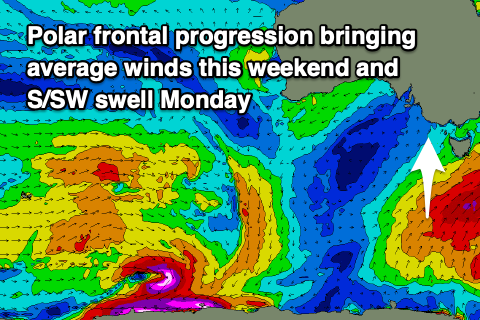 The high will eventually start moving east early next week, swinging winds to the SE on Monday along with the new S/SW groundswell which should maintain 3ft waves on the Surf Coast, 3-5ft to the east. Tuesday and Wednesday look fun and clean on the beaches but with small, easing surf.
Longer term, an inconsistent W/SW groundswell is likely later next week but we'll look at this closer on Wednesday.
Comments
Surely those other weather stations are inaccurate but it illustrates how it feels at MP on a Northerly - magnified!
No such thing as Strong NE :)
Maybe it just funnels and intensifies down the bay?
Very nice waves on Saturday btw
It always picks up speed over the bay but that is a classic anomaly on the graph.
Winds are improving now, just strengthened with a little meso-scale feature.
Your not wrong. Meso-scale ftw.
VJ, check your old local this AM..
https://www.swellnet.com/reports/forecaster-notes/western-australia/2022...
Yep Craig she looked sweet. The beachies shine with those spring banks, sometimes they can be pretty deep too! On the way over soon. I've told the young fella to get some goodness here while I'm away.
Solid and clean!
Anyone know whats up with the passenger jet doing circles snd the 4 helicopters?
Looks to be army heli. Maybe some training exercises?
Nice to see the WST back in action, polar front too, very old school. Good job Craig.
Thinking about your comment from the other day,
how much of our weak storm track/ blocking high swell drought is due to the volcano do you think?
Anyone think the water isn't as cold as it used to be? Maybe my wetsuit is just better than what it was a decade or two ago ... But was in the water for 2.5 hours today and only felt it in the last 20 or so.
yep im with you Anthony.the water has been warmish for winter!!!
Agree, I'm finding it the wind mostly that is the cold bit; the water's not too bad
Charts, graphs and anomaly galore regarding southern hemi cooling but is euro weather.
https://www.severe-weather.eu/global-weather/cold-anomaly-stratosphere-p...
Yeah incredible eh!
That's all in the stratosphere, it's not propagated or influenced the troposphere yet. But will do over the coming months/year.
The complexity of climate blows my tiny mind, I guess they're saying this has weakened the storm track because its all cooler than usual. That kind of explains the worst winter ever maybe?
Going through that article now, it's very comprehensive. Lots of blobs to interpret.
Remember when we had that vortex/anomaly caused by a wave developing up there in the lee of the S.American mountain ranges a few years back? (Craig pls correct terminology/recollection of event). For the SC that turned into a November with strong westerly component, and good swell. It was good. Wonder what this one will bring.
Edit: correlation not being causation etc etc, but their example of a cold winter for E US and Europe is exactly what they don't want with their fuel/gas situation there.
Boffin level
Surf coast and Vic feature in pretty much every anomaly too
So I've had the neighbours murderous feral feline in my sights to sacrifice to Huey god of wind swell and waves, glad I never pulled the trigger, it's to Vulcan I should dedicate it
Yeah the sudden stratospheric warming event back in September 2019. It's been a crazy few years since then of weather watching!
It looks like the initial cause of the event was the strongest on record positive IOD event which then disrupted the atmospheric flow, exacerbated by the Andes and so on.
Looks like Victoria is getting some great waves , spring has sprung , condition’s look glorious on the cams today