Fun swells with favourable winds

Western Australia Surf Forecast by Craig Brokensha (issued Monday August 29th)
Best Days: Today, tomorrow, Wednesday, Thursday, Friday, Saturday in the South West
Features of the Forecast (tl;dr)
- Further drop in SW groundswell tomorrow, with a reinforcing mid-period SW swell for the PM, easing Wed
- Light E/NE tending weak sea breezey winds tomorrow, moderate SE tending gusty S/SE into Wed
- Large SW groundswell Thu with fresh E winds, tending variable some spots and S/SE others
- Easing S/SW swell Fri with strong E tending fresh E/SE winds
- Easing surf on the weekend with strong E/NE winds Sat, weaker SE tending SW Sun
Recap
Poor conditions to kick off the weekend with strong onshore winds and a small start with size developing into Saturday afternoon.
Yesterday our XL SW groundswell filled in with more workable conditions for the South West though Perth and Mandurah were best with lighter winds and 3-4ft sets across the latter, 2-3ft in Perth.
This morning is the pick though with clean conditions across all locations and large, easing surf from 10-12ft in the South West, 3ft+ in Mandurah and 2-3ft across Perth. Sea breezes are only due to be light this afternoon, with fun waves due to continue across the state.


Pumping this morning
This week and weekend (Aug 30 – Sep 4)
The weekend's XL SW groundswell will continue to ease in size tomorrow morning but a new pulse of reinforcing SW groundswell is due into the afternoon, holding Wednesday morning.
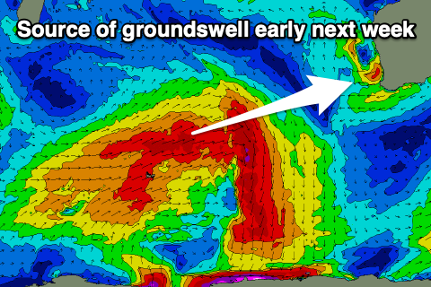
This swell was generated by a fetch of gale to severe-gale W/NW winds pushing under Heard Island on the weekend, with the front now much weaker and to our south-west.
 There's been no change to the expected size with 6-8ft sets due in the South West, (possibly smaller in the morning) with 2-3ft sets in Mandurah and 2ft waves across Perth, easing from a similar size Wednesday.
Conditions will be good with a light E/NE offshore across Margs, E/SE in Perth and Mandurah, giving into weak sea breezes while a trough moving through the South West into the late afternoon/evening should see morning SE winds Wednesday, freshening from the S/SE into the afternoon.
Moving into Thursday and we've got our larger, SW swell due, generated by a broad but overly strong polar front that's currently south-west of us. A slow moving fetch of strong to gale-force W/SW winds should produce a little more size than tomorrow and Thursday's swell, coming at a more consistent 8ft across the South West with 2-3ft sets in Mandurah and 2ft'ers across Perth.
 Conditions look great with a moderate to fresh E'ly offshore on Thursday, S/SE across some parts into the afternoon but variable across most others. Stronger E tending weaker E/SE winds are due Friday as the swell eases back in size from 6ft in the South West. 2Ft+ Mandurah and 1-2ft across Perth.
Into the weekend the swell and size will continue to fade with gusty offshore winds as a low forms on top of us, poor into early-mid next week as the low shifts east, bringing S/SW winds.
This will spoil a good sized W/SW groundswell but we'll have a closer look at this on Wednesday.