Good waves opening up on the beaches later week

Victoria Forecast by Craig Brokensha (issued Monday 23rd March)
Best Days: Keen surfers tomorrow, keen surfers for a period east of Melbourne Thursday morning, Friday until early afternoon, Saturday exposed beaches, possibly Sunday morning though windy
Recap
Our strong new S/SW groundswell offered solid waves across the state on Saturday but with onshore winds, workable through the day as they became light creating decent waves for the keen.
Sunday started clean early with a touch less size ahead of a strong SW change and good kick in new SW groundswell through the afternoon. This swell has started to ease through today with fresher onshore winds.
This week and weekend (Mar 24 – 29)
We've seen two swells impact the state from a strong node of the Long Wave Trough slowly moving east across us on the weekend and we're still seeing polar fronts falling under its influence as it restrengthens over New Zealand.
This will continue to keep the Southern Ocean active but it won't be until later in the week that we see local conditions improve.
 Our third pulse of reinforcing SW groundswell for tomorrow is on track with it generated by a weaker polar front over the weekend in the wake of the strong lows linked to Saturday and Sunday afternoon's swell.
The Surf Coast should persist around 4ft on the swell magnets on the sets, 5-6ft sets to the east, easing through the afternoon along with workable and light to moderate onshore S/SE winds.
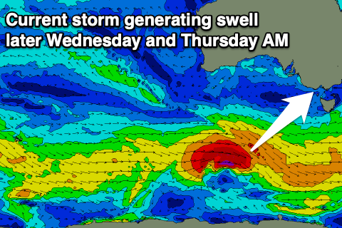
Come Wednesday we'll see the swell drop temporarily ahead of a new long-period SW groundswell into the afternoon. Conditions will become more wind affected though with moderate to fresh S/SW-S winds.
The new groundswell is being generated by a deepening low south of WA, with a burst of W/SW gales moving east, reaching severe-gale for a short period.
The groundswell is due later in the day with the size coming in at mostly 3ft through the day on the Surf Coast, 4-5ft to the east with a kick later to 3ft+ and 5ft+ respectively.
Thursday morning is likely to see the most size ahead of an easing trend, with sets dropping from the 4ft range on the Surf Coast, 6ft or so to the east as wind start to slowly improve.
The Surf Coast will remain average with moderate to fresh SE winds, likely tending E/SE for a period on the Mornington Peninsula through the morning.
Friday looks the pick though with offshore N/NE winds developing after dawn (giving into afternoon sea breezes) along with fun easing sets from 3ft on the Surf Coast magnets, 4-5ft to the east.
Saturday will be nice and clean again with persistent offshore N/NE winds but smaller waves best suited to the exposed beaches and likely coming in around 3ft+ or so. A reinforcing groundswell is due into the afternoon from unfavourably aligned but persistent polar frontal activity though likely not topping 3-4ft on the exposed beaches.
Sunday looks clean early but windy with the swell from Saturday afternoon easing, with a change likely into the afternoon.
Moving into next week and we've got a bit of Southern Ocean storm activity on the cards with a moderate to possible large long-period SW groundswell on the cards. Local winds look to be out of the eastern quadrant as a high moves in but more on this Wednesday.
Comments
I might go for a paddle tomorrow down at Crunchy Point. I can sense a daylight curfew could be coming. I will surf until it is banned in the present circumstances.
Yeah don't bother, save the petty money.
You need a 20 foot swell from the south for that place to break properly. You will only be padding.
Shame we can't go out with a nice thumping swell for the reefs. I fear we will be in lock down within the next 48hrs for at least 4 weeks. Hold tight folks, it's gunna get bumpy.