Slow drop in swell as winds deteriorate

Victoria Forecast by Craig Brokensha (issued Wednesday 1st January)
Best Days: Surf Coast Thursday morning, beaches into the afternoon, selected beaches Friday morning
Recap
Happy New Year everyone! Yesterday was poor across all locations with varying onshore winds and an average mix of swells, building a bit in size later in the day.
Today is much better with clean conditions on the Surf Coast and a new mid-period W/SW swell to 3ft+, not bad to the east with 4-6ft sets on the beaches. We'll see a bit more consistency and energy with the lower tide through the day ahead of sea breezes.
This week and weekend (Jan 2 - 5)
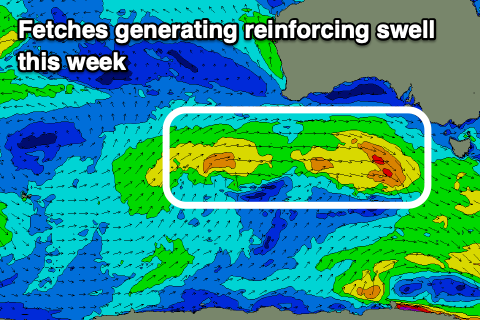
Today's mid-period W/SW swell is expected to ease a touch into tomorrow, but a cold front currently moving in from the west should generate some reinforcing swell through the day, with the Surf Coast swell magnets expected to continue to offer 3ft sets (smaller protected spots), 4-5ft on the Mornington Peninsula.
 We'll see the Surf Coast offering clean conditions again with a light W/NW offshore, giving into S/SE sea breezes.
Friday is now looking dicey with winds only shifting to the E/SE through the morning, creating bumpy conditions across all spots. The beaches east of Melbourne will handle them best though with easing sets from 3-4ft or so (maybe the rare sneaky bigger one) and 2ft to nearly 3ft on the Surf Coast.
Come Saturday there's a window of clean conditions at dawn with a N/NE offshore, but the Surf Coast will be tiny and the exposed beaches 2ft+ ahead of a strong W/SW-SW change.
As touched on in Monday's notes, the models were over-forecasting the size due on Sunday, mixing a very inconsistent and long-range W/SW groundswell with a more localised SW swell from a 'bombing low' deepening very late in our swell window. This localised SW swell now looks to be in line with forecasts now, with a very short-lived and south-east tracking fetch of strong to gale-force SW winds due to be generated briefly in our swell window Saturday.
 A spike in swell to the 3ft range is due on the Surf Coast Sunday morning, 4-5ft to the east but with poor S-S/SE winds in the wake of Saturday's change. Monday doesn't look any better with a small leftover swell and S/SE-SE winds.
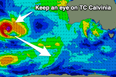
Longer term, the models are toying with Tropical Cyclone Calvinia which is east of Madagascar, drifting south-east and being absorbed into the westerly storm track and deepening as a strong low south-west of us early next week. This could generate a good SW groundswell for mid-late week, but we'll have a closer look at this on Friday.