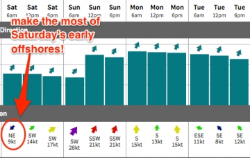
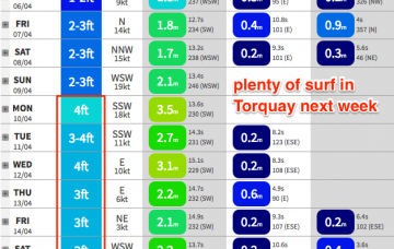
Great waves in many regions for much of the foreseeable future
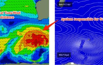
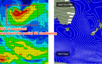
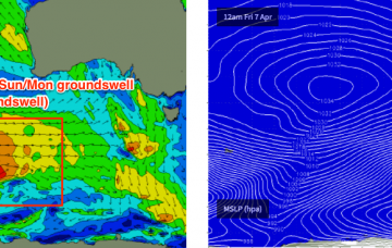
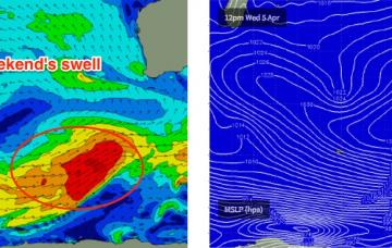
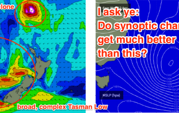
We’re still looking at a couple of tropical cyclones in the South Pacific over the forecast period.
Easter outlook is UNREAL regardless with good winds and a solid mix of S/SE swells plus a couple of E/NE swells from these cyclones and their surrounding features.
Saturday morning looks good down south.
The rest of next week looks busy with a steady progression of Southern Ocean storms generating back to back moderate SW groundswells for the region.
This front will clear to the east on Sunday leaving the region with light E/SE winds ahead of a weak afternoon sea breeze. As such we’re looking at an excellent day of sizeable waves across the region with fantastic conditions.
A rebuilding trough of low pressure over the Coral Sea will freshen trade winds in our mid range swell window and thus kick up a fun E’ly swell for SE Qld this weekend.
The models every so slightly eaed back the stretch of the E’ly fetch out of Cook Strait, so the resulting E/SE swell for Thursday will be a little smaller and a little later in its arrival than was suggested on Monday.
A series of fronts through the Southern Ocean will generate a small, slow increase in size over the coming days.
Winds will strengthen from the NNW on Saturday as a cold front approaches and this will create problems east of Melbourne. As such our weekend focus will be west of Melbourne.
We’ve had a steady progression of frontal systems through the Southern Indian Ocean over the last few days, and although they’re not overly strong and a large distance from the mainland, are generating new swell that will build slowly over the coming days.