Great waves in many regions for much of the foreseeable future

South-east Queensland and Northern NSW Surf Forecast by Ben Matson (issued Friday 7th March)
Best Days: Sat/Sun: fun easing leftover SE swell at exposed beaches, mainly Northern NSW. Sat/Sun/Mon: fun trade swell for SE Qld and Far Northern NSW. Wed: building S'ly swell with small waves at outer points. Thurs: mix of strong S/SE swell (mainly Northern NSW, smaller in SE Qld) and a brief flush of E/NE swell from a tropical cyclone. Easter Fri onwards: plenty of S/SE swell (mainly favouring Northern NSW) and some long range E'ly swell from South Pacific weather systems.
Recap: Surf size has slowly eased over the last few days, with a reinforcing SE swell maintaining strong surf today. SE Qld has managed 2-3ft sets both days but it’s been bigger south of Byron around 4-5ft. Winds have been mainly southerly, best suited to the points.
This week (Apr 6 - 7)
Note: Forecaster Notes will be brief this week because Craig’s on leave
In brief points today:
1. The current SE swell will ease into Saturday morning though exposed beaches south of Byron should still see some early 2-3ft+ sets, before it loses a little more size during the day. Expect smaller surf from this source north of the border.
2. A redeveloping ridge through the Northern Tasman Sea and Coral Sea will build a trade swell across SE Qld and Far Northern NSW over the weekend, though the fetch isn’t expected to consolidate quite as much as was modelled in Wednesday’s notes. This has pegged back surf size to around 3ft across the Sunshine Coast, 2-3ft across the Gold and Tweed Coasts and then smaller surf as you track south from Ballina. It should build through Saturday and then level out into Sunday and Monday before easing very slowly from Tuesday morning.
3. The developing ridge will maintain SE winds across SE Qld and Far Northern NSW this weekend though we’ll see lighter winds south of Ballina, and consequently a period of SW winds early morning here. North from Ballina, only a few locations will experience early light S/SW winds (i.e. southern Gold Coast). Sunday will see light variable winds and sea breezes as the ridge pushes away from the mainland. A lingering S/SE breeze is likely across the Sunshine Coast though.
4. A front will cross the Southern NSW coast on Sunday night, with strong to gale force SW winds developing in its wake. However at this stage this system is expected to remain outside of our south swell window until Tuesday, which means the earliest we’ll see a swell increase will be Tuesday afternoon (Northern NSW, specifically the Mid North Coast) with everywhere else seeing an increase into Wednesday. Once the swell kicks it’ll be large and windy from the south, up to 5-6ft+ at south facing beaches but only workable at very sheltered locations due to the size and conditions.
5. This swell direction won’t be great for the SE Qld points so I’m expecting only small surf through Wednesday and Thursday from this source, maybe 2-3ft at some outer points and smaller surf elsewhere (though bigger at exposed northern ends, where it’ll be horribly wind affected).
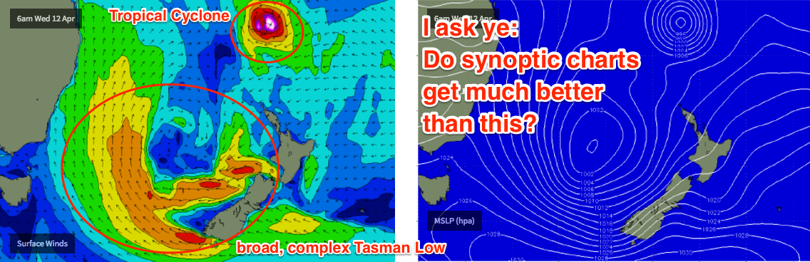
6. The Tasman Low resulting from this development will meander through the southeastern Tasman Sea for the rest of the week, so once Wednesday’s short range swell throttles back we’re looking at strong S/SE groundswells across Northern NSW from Thursday to Easter Sunday. Surf size is unlikely to drop below 3-4ft throughout this entire period and several days (Wed, poss early Thurs) could push 4-6ft at reliable south swell magnets.
7. This S/SE swell will be much smaller north of the border but there’ll be enough size for some small runners on the outer SE Qld points (2-3ft at times) from Thursday to Easter Sunday, and winds will be ideal too.
8. We’re still looking at a couple of tropical cyclones in the South Pacific over the forecast period. But the models are moving around a LOT on this so I’m hesitant to pin anything down right now. Although we're likely to see some good surf eventuate, no major surf size is expected from either source right now: the models have currently weakened the distant Sth Pac cyclone, with a long - though only moderate - fetch associated with a high pressure system east of NZ. However, while they have majorly intensified the cyclone between Fiji and New Cal, with hurricane force winds possible, the fetch length is only short due to a lack of a supporting ridge to the south, and it’s expected to track unfavourably SE too. Expect this guidance to move around over the coming days. There's certainly the potential for this outlook to be upgraded significantly but we need a few more days to have any confidence. For now, I’m expecting a late Wednesday increase across SE Qld and Far Northern NSW - will it be visible beneath the solid short range S’ly swell? - with sets building into the 4ft range for Thursday from the E/NE. Watch this space, it's gonna change.
6. Easter outlook is UNREAL regardless with good winds and a solid mix of S/SE swells plus a couple of east swells from the aforementioned cyclones and their surrounding features.
Comments
Been a while since the charts looked remotely like this .....or might look like this.
Yew! Love your work Ben!
Couple winders at Snapper earlier this morning. It's mainly smaller than this though.
Byron is smaller but looking pretty fun.
Vanuatu Weather bureau expecting cyclone to form tonight.
New Cal looks to get smashed!!!
Yeah that has come up quickly! Looks like a supercharged system next week with the cyclone and Tasman Low merging. Big Easter swell for NSW!
Looks to be a Big blustery bank eating swell with shit winds
Best morning on the Sunny Coast in a while.
Love your work Ben, just in time for my annual pilgrimage back to the stompin' grounds. Now I just have to see a man about a board...
Yamba looking quite nice with a bit of tide on it this morning.
Really fun waves as the tide dropped
Gotta love Autumn
Thaaat's more like it.
Yep, GC beachies fun as the tide dropped as well. Bit of push in the swell too.
I can confirm that even the SC had some banging waves this arvo when the tide dropped.
Happy