Excellent long range outlook for Southern NSW, but windy early next week

Sydney, Hunter and Illawarra Surf Forecast by Ben Matson (issued Friday 7th March)
Best Days: Sat: get in early for the tail end of today's swell. Tues/Wed: large S'ly swell though windy at times. Thurs/Fri/Sat/Sun: strong S/SE swells with good winds. Friday onwards: mix of E/NE swells for quite a few days, sourced from two cyclones in the South Pacific.
Recap: Thursday offered excellent surf with initially easing E/SE swell from Wednesday ahead of a (relatively) long period E/SE groundswell mid-late afternoon that bumped up surf size back into the 4-5ft range. Surf size has eased from a similar size today and is now smaller across the coast, but still unreal in quality. Winds have been favourable light and variable.
This weekend and next week (Apr 8 - 9 onwards)
Note: Forecaster Notes will be brief this week because Craig’s on leave
In brief points today:
1. Today’s E/SE groundswell will continue to ease overnight. Early Saturday morning could see occasional 2-3ft sets at a handful of reliable swell magnets but it’ll be down to 1-2ft by mid-late morning and through the afternoon, and a lot less consistent. Expect very small to prevail into Sunday though we may see a small lift in tradeswell spread, from a minor southward extension of the E’ly flow across the Northern Tasman Sea today and tomorrow. I can’t see much more than 1-2ft from it though.
2. Winds will be light and variable tending N’ly on Saturday, then freshening N’ly on Sunday. Sat AM is therefore the pick of the weekend.
3. A front will cross the region Sunday night, with strong to gale force SW winds developing in its wake. However the models are still unsure on the exact position of the low, and consequently whether we’ll see a swell generating fetch develop in our short range swell window early Monday, or overnight. There’s a chance that we could see multiple low pressure cells off the South Coast so I can’t rule out a localised rapid increase in size on Monday afternoon, but Tuesday is where we’ll certainly see the bulk southerly swell fill in, with 6-8ft sets at south facing beaches and strong to gale force S’ly winds.
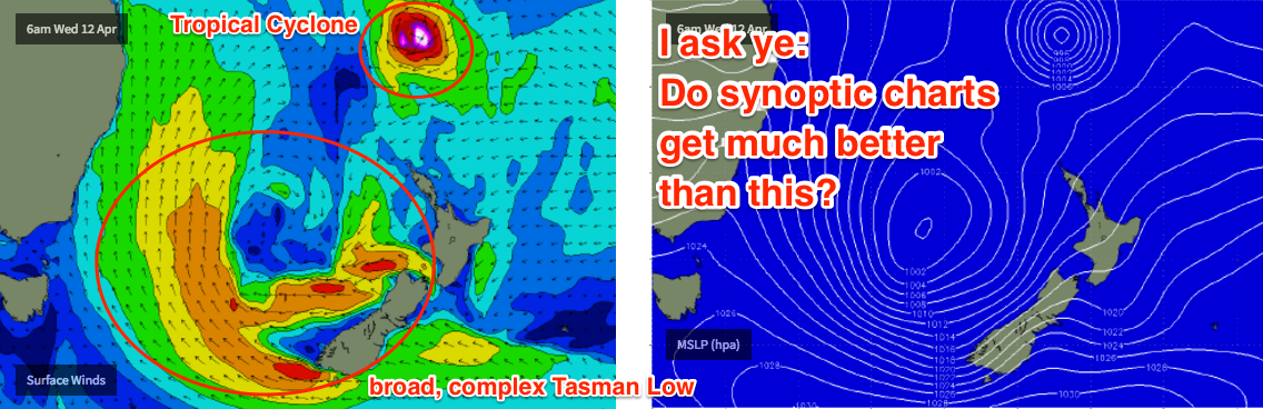
4. The Tasman Low resulting from this development will meander through the southeastern Tasman Sea for the rest of the week, so once Tuesday’s short range swell throttles back we’re looking at moderate to large S/SE groundswells from Wednesday to Saturday or perhaps even Easter Sunday. Surf size is unlikely to drop below 3-4ft throughout this entire period and several days (Tues, Wed, poss early Thurs) could push 5-6ft+ at reliable swell magnets. Surf quality will get better as the week drags on, as will local condtions as the winds abate. So there's no need to rush into this event unless you want to surf protected spots that require a lot of size.
5. We’re still looking at a couple of tropical cyclones in the South Pacific over the forecast period. But the models are moving around a LOT on this so I’m hesitant to pin anything down right now. Although we're likely to see sme good surf eventuate, no major surf size is expected from either right now: the models have currently weakened the distant Sth Pac cyclone, with a long - though only moderate - fetch associated with a high pressure system east of NZ. However, while they have majorly intensified the cyclone between Fiji and New Cal, with hurricane force winds possible, the fetch length is only short due to a lack of a supporting ridge to the south (and an unfavourable SE track). Expect this guidance to move around over the coming days. There's certainly the potential for this outlook to be upgraded significantly but we need a few more days to have any confidence.
6. Easter outlook is UNREAL regardless with good winds and a solid mix of S/SE swells plus a couple of E/NE swells from these cyclones and their surrounding features.
Comments
C'mon, c'mon, c'mon, c'mon......
Looks good on the forecast! plenty of swell of late here on the Mid Nth Coast but generally conditions have been ordinary! love to see those cyclones deliver some long period sustained east swell! Bring it on!
Still a few 2-3ft sets across the Sydney region but they're pretty inconsistent now. Doesn't look like there'll be much leftover by this afternoon.