Quality E/SE swell late Thursday, early Friday

Sydney, Hunter and Illawarra Surf Forecast by Ben Matson (issued Wednesday 5th March)
Best Days: Thurs/Fri: quality E/SE groundswell with good winds. Tues/Wed: large S'ly swell though windy at times. Likely to persist from the SE through the second half of the week and maybe next weekend. Late next week, into the weekend and early in the following week: good long range E/NE swell.
Recap: Plenty of surf but terrible conditions with mainly onshore winds. A few windows of light variable winds have started to open up today though. Better conditions south from Wollongong too with smaller surf.
This week (Apr 4 - 7)
Note: Forecaster Notes will be brief this week because Craig’s on leave.
In brief points today:
1. The models ever so slightly eased back the strength of the E’ly fetch out of Cook Strait on Tuesday, so the resulting E/SE swell for Thursday will be a little smaller and a little later in its arrival than was suggested on Monday. I’m not expecting any action until well after lunch Thursday; on dark we could see inconsistent 3-5ft sets but it'll be much smaller prior to then. It’ll ease from a similar size early Friday, down to 2-3ft by mid-late afternoon. Conditions will be clean with light winds.
2. Much smaller surf is expected over the weekend, with light winds Saturday freshening from the north on Sunday. Aim for Sat AM as it'll have the most size from the easing E'ly swell.
3. A cold front will cross the region overnight Sunday with a deep Tasman Low forming off the South Coast Monday. Models are split on the timing and have shunted the Monday increase to Tuesday. Either way we’re looking at a lot of size (6-8ft south facing beaches?) and a lot of wind from the south too. This system will meander through the Southern Tasman Sea and thus dominate our swell window through the middle of the week too. In fact it could linger in the SE Tasman mid-week and supply a solid secondary SE swell later next week or early in the weekend.
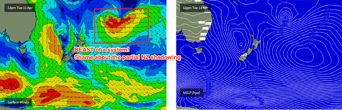
4. We have a couple of cyclones likely to develop in the South Pacific over the forecast period, the first one well SE of Fiji later this week which looks like it’ll tie in with a broad high well east of NZ mid-next week onwards, generating an incredible E’ly fetch - that’ll be mainly shadowed across NSW coasts by New Zealand. D’oh! But need to keen an eye on it - well probably see some good long range swell from it (late next week onwards, more likely next weekend and beyond) but a much diluted version. The second cyclone may develop SW of Fiji early next week and could push into a more favourable part of our swell window during the week. Still early days though.
Comments
Leading edge hit the Sydney buoys around 1:30pm with peak periods around 12.8 seconds.
Surf size seems to be in the 4ft+ mark now. Looks strong too. Queensy on the pump!