Slowly building swells in Vicco; long range looks good for Easter

Victorian Surf Forecast by Ben Matson (issued Wednesday 5th March)
Best Days: Fri/Sat/Sun AM: small clean waves in Torquay. Tues/Wed/Thurs: small/mod sized SW swell for Torquay coast though winds may veer E'ly. Easter Fri/Sat: fun surf with good winds in Torquay. Chance for a big windy swell late in the Easter break.
Recap: Small surf with E’ly winds Tues now light N’ly.
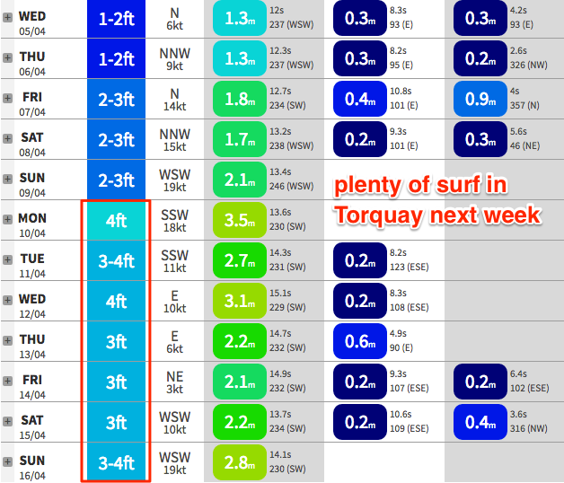
This week (Apr 4 - 7)
Note: these Forecaster Notes will be brief this week as Craig is on annual leave
A series of fronts through the Southern Ocean will generate a small, slow increase in size over the coming days.
Due to the large travel distance, set waves will be extremely inconsistent, however the Surf Coast should see wave heights around 2ft, occasionally 2-3ft through Thursday afternoon and into Friday.
It’ll be bigger east of Melbourne (3-5ft) but still manageable with winds expected to be mainly N’ly, occasionally NNE.
This weekend (Apr 8 - 9)
Winds will strengthen from the NNW on Saturday as a cold front approaches and this will create problems east of Melbourne. As such our weekend focus will be west of Melbourne.
Initially, surf size is expected to remain relatively small on Saturday, similar to what’s expected on Friday - that is very slow, very inconsistent 2ft to maybe 2-3ft sets in Torquay.
A gusty SW change will push through at some point on Sunday but the groundswell increase behind it won’t be massive (so protected bays and points won’t have much size, even Western Port could struggle) and these winds will write off the exposed beaches.
In fact the latest model runs have thrown a curveball, splitting the front away from the low and riding it higher through the Bight, outside of our swell window. This would delay the change (and result in W/NW winds Sunday morning) but with no major size increase until overnight Sunday. I’ll have more idea on that in Monday’s update.
Anyway for now it looks like a small, slow weekend west of Melbourne.
Next week (Apr 10 onwards)
With the front now delayed and split, the size prospects behind this system have been weakened a little, but we should still see - as a minimum - solid 3-4ft surf in Torquay on Monday, possibly bigger. Though it’s likely to remain wind affected under a predominant post-frontal SW breeze.
An intense cut off low south of South Africa today is expected to track SE towards Antarctica and then run along the ocean shelf into the weekend, generating a long period SW groundswell that will fill in behind Monday's groundswell. This should maintain anywhere between 3-4ft in Torquay from Tuesday through Thursday of next week, possibly a little higher at times (likely on the Wednesday, near 3-5ft), though very inconsistent. However as mentioned on Monday, we will be at risk of developing easterly winds these days due to the southern latitude of the storm track.
Easter is still on target for plenty of surf too, with a couple of days of favourably light winds ahead of a possibly gusty cold front later Sunday and into Monday and a large increase in short range swell. At this stage we’re looking at fun 3ft surf in Torquay on Good Friday and Saturday.