Indonesia/Maldives forecast Jun 19

Indian Ocean Basin analysis by Craig Brokensha (issued Thursday 19th June)
This week through next (Jun 20 - 27)
The swell should have pulsed and then eased out of the S/SW later Tuesday and into yesterday morning, smaller today.
We then look at the mixed SW groundswell pulses due through tomorrow, with a peak expected into the afternoon.
The best of these swells was generated by a tight, intense low forming south-east of Madagascar, projecting east-northeast while generating a tight fetch of gale to severe-gale winds, with a period of embedded storm-force winds seen.
This swell has performed well across Western Australia today with no change to the expected size tomorrow afternoon, with large surf due, easing Saturday.
We then have our larger SW groundswell into Sunday/Monday.
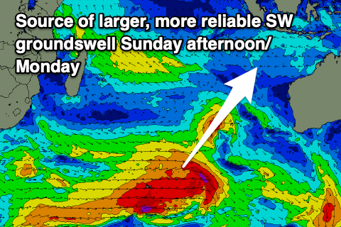
There’s been no changes to this swell either, with an expansive polar frontal progression that formed in the Southern Ocean, south-east of South Africa generating various fetches of gale to severe-gale W/SW winds while moving slowly east. A final fetch of gale to severe-gale W/SW winds east of the Heard Island region Tuesday evening finished off the job, with a large groundswell due to peak Sunday afternoon/Monday morning before easing into Monday afternoon.
Our moderate to large, reinforcing mid-period S/SW swell energy for Monday should slow the easing trend with it generated by a surge of strong S/SW winds up past the Western Australian coast today and tomorrow before feeding into the top of a strong high moving in behind it Saturday.
The inconsistent SW groundswell due into the end of the week has been downgraded a little, with the Southern Ocean frontal progression linked to it, forming south of South Africa yesterday now due to be weaker and not as consolidated as it moves east across the Heard Island region.
In saying this the Mentawais should still be moderate-large with moderate + sized surf around eastern Indonesia.
Luckily the weekend’s possible large SW groundswell is still on track with a high tracking mid-latitude low expected to push up past Madagascar from under South Africa later this week and then generate a slow moving fetch of S/SW-SW gales, possibly reaching severe-gale at times.
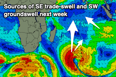
A large, prolonged SW groundswell is due from this source, building Saturday, large late, holding Sunday and then easing slowly Monday.
Following this the outlook is quieter but more on this Tuesday.
Our weaker SE-S/SE trades will strengthen from the E/SE-SE over the weekend, persisting most if not all of next week.
In the Mentawais, variable winds are due, possibly shifting N/NW through early-mid next week then variable again thereafter.
----------------------------------------------
Maldives:
A large S’ly groundswell should be in the water across the southern atolls today, easing through tomorrow ahead of a secondary, slightly smaller but similar groundswell later Saturday/Sunday. This was generated by the expansive Southern Ocean frontal progression moving across the Heard Island region and then we get to the swells forming off South Africa.
The first system passing under South Africa yesterday should produce a moderate-large sized S’ly groundswell for Tuesday, while the system passing up past Madagascar looks to generate a larger, prolonged S’ly groundswell for later next week.
Trade-swell wise and our spike in S/SE swell for tomorrow afternoon/Saturday morning hasn’t changed.
We then look at the moderate to large sized mid-period SE swell due later next week, with the fetch of E/SE-SE trades setting up on top of a strong high sitting west of Western Australia due to form over the weekend, holding early next week before slowly weakening the rest of the week.
The swell should build through Wednesday, peak Thursday before slowly easing Friday and into next weekend.
Local winds still look light out of the W-W/SW across northern and central locations with more variable winds to the south tomorrow and Saturday. We’re then set to see winds shift more SW through Sunday and next week across northern and central locations, fresher S-S/SE in the south.
Eastern Indonesia:
Large mix of SW groundswells building tomorrow to 6-8ft across exposed breaks, easing Saturday.
Larger, less consistent SW groundswell building Sunday, reaching 8ft across exposed breaks into the afternoon, holding Monday morning.
Reinforcing mod-large mid-period S/SW swell for Monday, easing Tuesday.
Inconsistent, moderate + sized SW groundswell building later Wednesday, peaking Thursday to 6ft across exposed breaks.
Larger SW groundswell building Saturday, peaking Sunday to 6ft to occasionally 8ft, easing slowly Monday.
Weak SE-S/SE trades over the coming days, strengthening from the E/SE Sunday into next week. Light, local offshore winds each morning.
Uluwatu 16-day Forecast Graph/WAMs
Western Indonesia/Mentawais/South Sumatra:
Large SW groundswell building later today, peaking tomorrow to 6-8ft across exposed breaks, easing Saturday.
Large, less consistent S/SW groundswell building Sunday afternoon to 8ft across exposed breaks, holding Monday morning.
Moderate sized S/SE trade-swell for early-mid next week.
Moderate to large SW groundswell building Wednesday to 6ft across exposed breaks, peaking Thursday to 6ft+.
Larger SW groundswell building Saturday to 8ft, easing slowly Sunday.
Variable winds this period possibly N/NW-NW early-mid next week.
Mentawai 16-day Forecast Graph/WAMs
Maldives:
Easing S’ly groundswell tomorrow with a small-mod sized, mid-period S/SE swell for the afternoon, easing Saturday.
Large S’ly groundswell building Saturday afternoon, peaking Sunday to 5-6ft across exposed breaks, easing Monday.
Moderate to large S/SW groundswell building later Monday, peaking Tuesday to 4-6ft across the southern atolls.
Large S’ly groundswell building Thursday afternoon to 6ft across the southern atolls, easing Friday.
Moderate to large sized SE trade-swell building Wednesday, reaching 5-6ft across the central atolls Thursday, easing slowly Friday.
Weak W-W/SW winds across northern and central locations tomorrow and Saturday with more variable winds to the south.
Winds tending more SW from Sunday through next week across northern and central locations, fresher S-S/SE in the south.
Comments
Latest notes are live.
Rightio. Looking to the brains trust here.
I’m staying at Kandooma. Leaving tomorrow. I’ve packed my high performance twin plus trailer that is great up to about 5 foot. I’ve packed a board a couple of inches longer but it’s still a twin plus trailer.
Am I going to be wanting a pin tail given the above forecast? If so it means unpacking and repacking
Easy solution take 3 boards?
Had vowed not to . Am going on a romantic holiday with my new MR twin and am taking my mrs.
Buy her a video camera with big zoom lens
Surf trip report required :) I'm going to Kandooma 22nd July. Looks like you are in for some good swell back end of next week. 3 boards as per DW recommendation.
Thanks guys. I’m limiting myself to two boards for a one week trip. I’ll just have to manage it . I’ll report back in a bit over a week.
Have a great trip
Yes let us now how you go!
It was nice to rest the bod today in preparation for the upcoming week, thanks Craig.
any crew over in Bali/Lombok/Sumbawa? whats the water temp like atm? last time i was over it was cold and just started to pack as im over there from Tuesday for a week strike mission as i cant cop whats happenin here NNSW/SEQ. @surfgeo im also looking at me quiver and figurin that shit out too as i wanna pack light for this one
I was in Bali and sumbawa a last week. Water was really warm. Absolutely no need for a wetsuit
nice mate, wasnt thinking wettie just a hot top or vest boardies it is
looks dire for the week after next doesnt it? 2-3ft at Ulus in July?
you can all relax, back to usual programming on the latest forecast