Decent westerly swell from tomorrow, easing as winds go more north

Victorian Forecast by Craig Brokensha (issued Monday May 16th)
Best Days: Tomorrow, Wednesday, Thursday later to the east, Friday afternoon to the east, Saturday afternoon to the east, Sunday
Features of the Forecast (tl;dr)
- Mod-large W/SW groundswell for tomorrow AM, easing and smaller Wed
- Moderate sized mid-period W/SW swell building tomorrow, easing Wed
- Strong W/NW tending W-W/SW winds tomorrow
- Moderate W/NW tending NW winds Wed
- Smaller Thu with N/NW tending N-N/NE winds
- Small, inconsistent W/SW groundswell for later Thu, peaking Fri, with a secondary pulse Sat
- N/NW tending N/NE winds Fri, N tending N/NE Sat
- Moderate sized, inconsistent W/SW groundswell for later Sat, peaking Sun with strong N/NE winds
Recap
Easing levels of swell were seen over the weekend with fun, inconsistent waves across the Surf Coast Saturday, tiny yesterday morning. The exposed beaches to the east improved through Saturday with the rising tide and northerly winds, while yesterday was OK as well but still a touch wind affected.
Later in the day yesterday a small mix of mid-period swells offered a little lift in size, best across the Surf Coast for the patient under the gusty northerly wind.
This week and weekend (Jun 17 - 22)
The coming period revolves mostly around the solid westerly swell due tomorrow across the state, generated by an initially very strong but weakening low moving in from the south-west of Western Australia since Friday.
This low was initially tight and generated a great fetch of storm-force W’ly winds, weakening while slowly moving east and under Western Australia, with it breaking down below gale-force once pushing under the Bight yesterday evening.
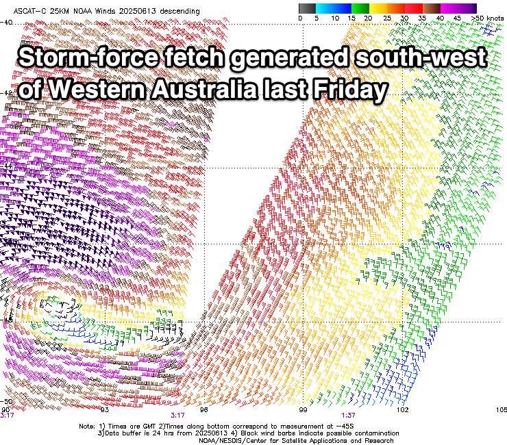
While all this activity has been mainly in our western swell window, the strength and projection of the low have been ideal and we should see a moderate to large W/SW groundswell from this source peaking tomorrow morning.
The remnants of the low will move slowly east with the swell and continue to generate a fetch of strong W/SW winds while pushing through Bass Strait tomorrow and this will bring some additional mid-period noise to the mix.
Size wise, the Surf Coast should come in at 4-5ft tomorrow across the magnets with the rare 6ft’er possible, while to the east we’ve expecting surf in the 8ft range.
Both swells should then ease into Wednesday, though the mid-period energy looks most dominant, easing back from the 4ft range on the Surf Coast, 6ft+ to the east and then smaller Thursday.
Local winds will be strong out of the W/NW tomorrow, shifting W-W/SW into the afternoon, with Wednesday seeing a return to weaker W/NW winds, likely shifting NW later in the day.
Into Thursday as the size continues to ease, morning N/NW winds are due to shift more N-N/NE later, creating improving conditions to the east.
From later in the day Thursday but more so the weekend we’re expected to see increasing levels of small, W/SW groundswell filling in, generated by increasing Southern Ocean activity pushing slowly towards Western Australia, under the influence of a strong node of the Long Wave Trough.
Initial activity will be in our distant swell window and unconsolidated, with small, inconsistent pulses for Friday and Saturday not likely to top 2ft on the Surf Coast with 4ft sets to the east, but come Sunday, a better, more noticeable increase is due.

This will be generated by a great fetch of gale to severe-gale W/SW winds traversing the polar shelf across the Heard Island region over the coming days, with the activity stalling just east of that region into Wednesday morning.
An inconsistent, moderate sized W/SW groundswell should be seen from this source, arriving later Saturday but peaking Sunday to an infrequent 3ft+ on the Surf Coast and 4-6ft to the east.
Local winds through this period look out of the north with a N/NW tending N/NE breeze on Friday, N tending N/NE wind Saturday and then stronger N/NE winds Sunday.
Moving into next week and the progression as a whole looks to mobilise east, bringing larger, close-range energy through the middle to end of next week. More on this Wednesday.
Comments
Very disappointing today
Yep, looked very underwhelming again. I thought this west swell was going to provide much better surf, but alas, I'm going to be more conservative regardless of how good it looks on the charts.
The localised, low period energy didn't help either.
i love you lord craigos but i agree these west swells never live up to the hype, probably saw one three wave today on the reefs (I've never set foot in Hawaii)
West swells and any time there's a mix of swells, this tends to mean the reefs will be average to shit. Some spots are still manageable, most not worth the paddle out, especially if you add in the biting cold.
based on today's observations, what are you thinking for tomorrow?
I'd expect easing 3ft to likely 4ft sets across the magnets. The swell has a touch of longevity helped by today's mid-period stuff.
Thanks Craig
At least it was cold.
Today looks much better.
Spot on Craigos - seemed to strangely increase in size a bit through the morning.