Good swell for the weekend, large and windy mid-next week

Victorian Forecast by Craig Brokensha (issued Friday May 20th)
Best Days: Today exposed beaches, tomorrow exposed beaches, Sunday, protected spots Wednesday and early Thursday, Friday Surf Coast
Features of the Forecast (tl;dr)
- Small, inconsistent W/SW groundswell for tomorrow with N-N/NW winds
- Late increase in forerunners for a moderate + sized W/SW groundswell that's due to peak Sunday AM
- Moderate N-N/NW winds, strengthening from the N/NE into the PM
- Easing swell Mon with strong N winds
- Small to tiny Tue with strong NW tending W/NW winds
- Mod-large W/SW groundswell for Wed AM, with a larger mid-period swell for the PM
- Strong W/NW tending W/SW winds Wed
- Large, easing surf Thu with strong but easing W/SW-SW winds (possibly light W'ly early)
- Cleaner Fri and easing with W/NW winds
Recap
Wednesday’s swell eased off through yesterday with cleaner conditions across the exposed beaches to the east, though still mostly wind affected. Easing 4ft sets were seen with 2ft+ waves on the Surf Coast.
Today, some inconsistent, long-range swell is in the mix with northerly offshore winds, favouring exposed breaks across the coast.
This weekend and next week (Jun 21 - 27)
Today and tomorrow morning will consist of inconsistent W/SW groundswell from our far swell window, with sets expected to maintain that inconsistent 2ft across the Surf Coast and 3ft to occasionally 4ft to the east under favourable winds.
This afternoon, winds look to tend variable N/NW to the west of Melbourne and N/NE to the east, with tomorrow playing out a little less favourably as N/NW-N winds persist all day.
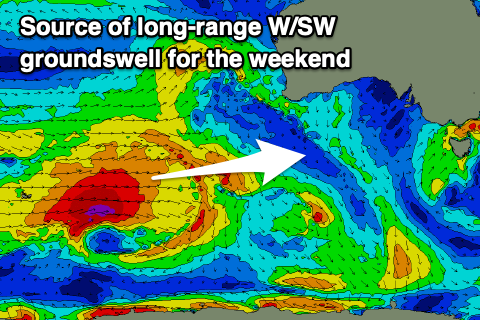
Later tomorrow afternoon we should see the start of a moderate + sized, long-range W/SW groundswell filling in, with a peak still due into Sunday.
This swell was generated by a great fetch of gale to severe-gale winds moving from the south-east of South Africa, across the Heard Island region, finally breaking down south-west of Western Australia on Wednesday.
It’ll be inconsistent but good quality with the Surf Coast magnets due to peak at 3ft to occasionally 4ft with 6ft sets to the east. Winds on Sunday look a little better for locations to the west of Melbourne with a morning N-N/NW breeze due to strengthen and shift N/NE into the afternoon. This will see locations to the east improving through the day.
Stronger N winds are then due on Monday as the swell eases, smaller into Tuesday morning as winds shift strong NW.
Looking at the developments for the middle to end of next week and we’ve got a series of strong mid-latitude storms due to move in and across us from Tuesday (under the influence of a strong node of the Long Wave Trough), with the first swell producer expected to spawn south of Western Australia on Sunday.
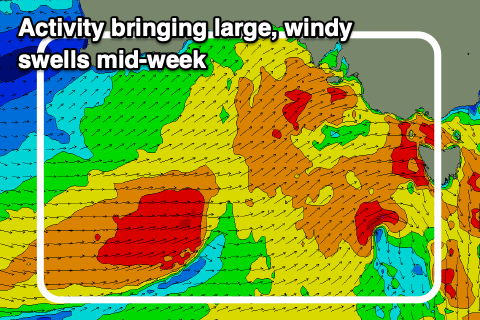
A fetch of W/SW gales will project east through Sunday/Monday, breaking down just west of us on Tuesday before a secondary system piggy-backs over the top and pushes through Bass Strait Wednesday.
This activity will generate a mix of moderate-large W/SW groundswell and building, larger mid-period energy for Wednesday, coming in 4-6ft across the Surf Coast in the morning, 6-8ft to the east, likely building more to 6-8ft and 8-10ft respectively into the afternoon.
Winds will be strong from the W/NW through the morning, shifting W/SW with the passing frontal system with Thursday likely to see large, easing levels of swell with strong but easing W/SW-SW winds. Early W’ly winds might be seen to the west of Melbourne but with lumpy conditions.
Friday looks much cleaner and better with moderate + levels of easing surf.
Following the large windy surf mid-next week we’ve got a secondary pulse of medium-range, moderate + sized SW groundswell on the cards for next weekend but more on this Monday. Have a great weekend!
Comments
A. Anyone one else lost the history on Pt. Nepean buoy?
B. What’s going on at Cape Sorrell haha?
Cheers for the early Craigoss!
A, no super annoying!
B, wigging hard.
Yeah, ive lost the history as well
I was thinking the same things, Nick. It is useful to see the swell trend on the Pt Nepean buoy. Cape Otway observations disappeared for a couple of days too, but they have come back now.
Yeah, ive lost the History on Point Napean as well. I shot them an email but havent heard anything as yet.
Vicwaves.com.au is a backup option when Vicports goes weird
We need to convince some one at Vicwaves to put a buoy off the Peninsula
The Boings camera Saturday between 1015-1030. Any idea what that is jumping out of the water towards the top left of the screen?? It certainly doesn't behave like a dolphin with the head shakes
From 10:22 that's either a dolphin or a very acrobatic shark rehearsing for Flipper 2026.