Sunday the pick of the forecast period in West Oz

Western Australian Surf Forecast by Ben Matson (issued Thursday 6th April)
Best Days: Sunday: solid swell in Margs with good winds. Easing Monday but equally clean. Plenty of surf all of next week and the following weekend too.
Recap: Slowly building swells have dominated the Margs region over the last few days, increasing back to 3ft on Wednesday then 4-5ft today though strengthening southerly winds have rendered surf conditions pretty ordinary. It’s remained very small in Perth and Mandurah.
This week and weekend (April 7th - 9th)
Note: Forecaster Notes will be somewhat brief this week as Craig’s on leave.
Friday is still looking a little ordinary across the Margs region thanks to a persistent S’ly breeze. We should see surf size in a similar range as today - maybe one or two bigger sets - but generally 4-5ft in Margaret River, and tiny up across the Perth and Mandurah regions.
The front generating the weekend’s swell(s) has been upgraded in the latest model runs. We’re looking at an initial pulse late on Friday afternoon up into the 6ft range, which should hold through into Saturday morning before easing a little into the afternoon.
The final swell in this succession will then push through for Sunday, and it’s now likely to max out around the 8ft mark across exposed Margaret River breaks. However the reasonable percentage of S in the direction will maintain smaller surf across Perth (1-2ft) and Mandurah (2-3ft).
The only concern for the weekend - down south at least - are local winds on Saturday. The benefits of the strengthening front is that we’re looking at larger wave heights for Sunday, however the downside is that this slightly stronger front will push a little closer to the mainland, and as it clips the region on Saturday will maintain a southerly flow. It shouldn’t be too strong but it’ll certainly take the sheen off the surface.
This front will clear to the east on Sunday leaving the region with light E/SE winds ahead of a weak afternoon sea breeze. As such we’re looking at an excellent day of sizeable waves across the region with fantastic conditions.
Moderate to fresh SE tending S’ly winds in Perth and Mandurah on Saturday will swing moderate E’ly for Sunday, so exposed beaches in this region should fare very well too for the second half of the weekend, though a little on the smaller side of the coin here.
Next week (April 10th onwards)
Monday’s looking great with a continuation of light E’ly winds under a high pressure ridge. Surf size will ease from Sunday but early morning should still manage some 5-6ft bombs at first light. Expect rapidly diminishing surf in the Perth and Mandurah regions with favourably light offshore winds here too.
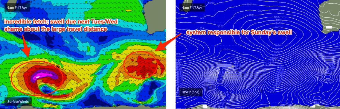
An intense Southern Indian Ocean low forming south of Madagascar over the coming days will generate a very long period W/SW tending SW swell that’s due to arrive on Tuesday and peak through Wednesday. However most of the swell production will occur west of Heard Island so the significant travel distance will cap surf size (maybe 6-8ft+ bombs) and there’ll be very long breaks between the sets of maybe fifteen to twenty minutes.
Beyond that the storm track east from Heard Island looks like it’ll fire up next week, with a couple of solid swells on the way - a moderate to large swell due mid-late week and then a potentially large to very large swell next weekend. More on this in Monday’s update.
Comments
Glad I went with gut feel and not model guidance for today - surf size has pulled back a little.
I didn't actually discuss it much in the notes above (short on time) but did discuss it in yesterday's video update.
Latest vid forecast.
Hi Ben - any chance there could be some cyclone swell in the mix over the coming week? Bom is showing TC Ernie will be a Category 3 by 7pm tonight..
Very low chance mate, probably nil at this stage. Main fetch around the cyclone is on southern flank aimed towards Maldives. Storm track also isn't favourable.
As a guide, Gnaraloo is much closer to this system and way more exposed to the swell direction too. The Gnaraloo data point is picking up a foot of N'ly swell at 11 seconds on Sunday from this cyclone.
https://www.swellnet.com/reports/australia/western-australia/gnaraloo/fo...
Wouldn't completely rule our a recurve back to the mainland later next week (not modeled at this stage) but it's a long shot right now.
Of more interest is another TC developing in its wake - near East Timor this weekend - which looks stronger and will probably track closer to the coast. This will be one to watch.
Great to hear your insights as always Ben. Fingers crossed we get another unicorn swell and everyone stays out of harms way.
Thanks mate :)
Looks like the late Fri/early Sat swell peaked over a much quicker time frame than expected (i.e. was expected to show a little earlier, and the peak plateau a little longer and hold out into this morning) - according to Cape Nat buoy data it went up and down under the cover of darkness! See below.
Night time is the bloody surf forecaster's curse, I tells ya.
Anyway still looks like there's a few stray 4-6ft sets at Mainbreak but as anticipated there's a S'ly breeze on hand (Cape Nat is light SE, Cape Leeuwin is mod SW; winds seem to be S'ly between the two).
There's no way they'll run the comp today. It's on for tomorrow for sure.
Here's a good example of the difference between the GFS model and the BOM's high res ACCESS-C model. It picks up the local boundary layer a little better due to the higher resolution - note the difference in winds south and north of Margs (winds sourced from Weatherzone).
Well, there ya go - so much for "There's no way they'll run the comp today. It's on for tomorrow for sure."
They've just announced that the Women's Semis wil kick off at 7am.
Why can't they wait until tomorrow? Surf will be bigger, better, cleaner.
Here's a theory - rather than finish both events on the same day - often diluting the impact of one over the other - they're going to give them each a seperate day to run, so that they get their own dedicated coverage.
Let's wait and see if they run the Mens straight after.
Hmmm, hold that thought....
The WSL initially posted this at 6:30am local time:
25 minutes later it's on hold!
Maybe they are worried by early on shore tomorrow aswell? Seen that type of forecast deteriorate earlier rather than later more often than not on this coast. On another side topic re contest , surfed yesterday with 2 flashy Americans that I assume are still in the contest, very underwhelming really, maybe just older eyes now (or the fact that the wsl has condensed surfing to be pretty much generic with the odd exception these days ie JJF), I remember years ago around the event and Brad Gerlock and Marty Thomas going nuts all over Margarets, doing stuff that nobody else could even get close too, I saw MT take off behind the peak and do the biggest vertical reo right off the main peak before smashing it a bunch of times more original surfing and ripping the shit out of it, mostly going left! These two yesterday were practising I guess, squabbling over shitty bumpy rights into the sthly, generic surfing, generic boards hard to tell them apart (except for a fancy hair doo which I admit was original but perhaps not that funtional in the wind either) anyhow just one more sleep and it will all be over thankfully, final in onshore rights again
Remember the big reos that tom carroll & dave mac were doing on the lefts , occys were also explosive , Thomas carroll did huge reos on ten foot lefts and to this day no one has bettered them .
Except for the windsurfers & kite surfers who do even bigger launches
I don't think it'll be an "early" onshore tomorrow Campbell - may end up swinging around the time of the Final (they have five hours of surfing plus breaks, so a 7am start gets them done around 12:30-1pm). If anything we should see light variable winds through the middle of the day.
Either way the forecast for tomorrow looks a lot better than what're they're seeing right now. And the model guidance has been consistent for many days now which greatly increases the confidence levels.
Interesting that they were meant to make another announcement at 7:45am, but half an hour later there's still no word publicly (website has been running repeats of the WSL banquet...!).
Ah, says next call 8:45am.
Dunno why they're bothering. Winds are only going to maintain, if anything slightly freshen from the S during the day anyway.
Looks very poor conditions for the finals womens. good punt on Sage at 3.60 if they send them out....and they are...
More west than south in the wind currently looking at the ocean in real life. Light and variable usually means light onshore in WA
That was terrible.
And it made me sad.
What's going on with Steph ?
( Full moon ? -Not as crude as it sounds)
WTF?
Forecast notes above - issued 2 days ago:
"The only concern for the weekend - down south at least - are local winds on Saturday. The benefits of the strengthening front is that we’re looking at larger wave heights for Sunday, however the downside is that this slightly stronger front will push a little closer to the mainland, and as it clips the region on Saturday will maintain a southerly flow. It shouldn’t be too strong but it’ll certainly take the sheen off the surface."
@thermalben,
You totally nailed the call. I guess they get their info from surfline only....pretty silly really, they are way off....west coast of california.
It's been really interesting to read the insight from yourself and also other people locally calling the swell too south for north point ,ect. Sat onshore ......
Local knowledge really pays off. Great work and enjoyable to watch it all unfold!
Thanks LD. Funny thing is that there's quite a few crew in and around the WSL who do use Swellnet forecasts.. it's just weird to see JMD claim publicly that they didn't know it was going to be southerly on Saturday when there were multiple sources suggesting this was a very real possibility.
Was she goin off the forecast earlier in the week when it looked like Saturday was the day...but its been forecasted for onshore Sat since Tuesday
Models have moved around a little - Wednesday was still showing early light E'lies then S'ly during the day - but since Thursday morning there's been a risk of southerly winds today - and it was reiterated in Friday's updates too.
I mean, even the BOM - conservative at the best of times - were mentioning even stronger onshore winds for today, in their Thursday morning update.
Sunday's been the biggest and best day for quite some time.
At an event level they should be checking in with the official forecaster (which is Surfline) twice a day as a minimum. At least, that's what I was doing when I was working on these events.
Well done Sally, surfed really well in the Final in pretty tricky waves.
Tomorrow will be way better surf .
12 second period muck today sorry ladies .
Do any of these people consult the locals? Anyone around here knows you can't get excited about a forecast until you are 2 days out. Even then it's best to wait and see , the old fashioned surf check. But even by Wednesday most crew knew Saturday was gonna be shitty.
Wasn't there some local consultation re: North Point? Jake Pato had a pretty firm view on things.
Jake the Snake was predicting best ever North for that day, even a couple days out. He probably gets wind of a good Day there via text more so than really being in tune with it. It was pretty obvious to a lot of keen locals it was gonna be too south for anywhere near classic NP.
Depending on your ability to interpret forecast data is a big factor in knowing if the surf will get good, 2- 1o days out it can be done for the southwest region . The odds vary a lot but with Swellnet 15 day forecasts every so often they succeed at it . Theres no way around having to pay a lot of attention to every update tool if your really hunting for something special .
Jake pattos from yallingup (when he's around anyhow) different climate up there on a daily basis, prob was offshore there this morning
Final days Swell is going over three metres by the look of the latest data, but that swell period is still weak @12s currently. albany buoy @13.5s. . soueast breeze blowing overnight .
tide is a bit low early especially for Box although the short period will favor Box .Barometric pressure over 1027..
http://www.bom.gov.au/wa/observations/coastal.shtml
NAT Buoy data http://www.transport.wa.gov.au/imarine/naturaliste-tide-and-wave.asp
Buoy data a little underwhelming at the moment, but wind are looking great - light NE at Cape Leeuwin and light SE at Cape Nat, so should be straight E'ly at Margs. Albany buoy is rising but swell direction is very south here (swell direction is SW at Cape Nat). Should see see plenty of 6ft sets at Main Break though may not get much bigger than that, unless we see a further kick in size.
Sets seem to be aorund the 6ft mark at the moment, may be one or two bigger bombs at times. Conditions are primo too. There's a bloke slotted in the surfcam grab below (didn't make it out though).
This grab manages to show the size a little better.
And this one too.
Solid sets from the WSL's live feed.
Wow.. next set was even bigger.. gotta be easy 6ft, almost 6-8ft? Check the size of the bloke in the red circle - he got properly slotted shortly after too.
Next wave cleaned up a bunch of guys.
The nat buoys @ 2.6m @14sec , you have whats being called 6-8ft Mainbreak .
Todays swell is not as good as it could have been potentially with the period barely 14secs and swell height failing to reach 3 metres on the NAT buoy.
Hopefully this example of the buoy reading vs the mainbreaks actual wave size is noticed for future reference.. the next time the swells reading 4m @ 18 sec Nat buoy , dont be calling it 10-12ft please .
Clam, there are inherent flaws in the WA buoy data (all of them) which means I have little confidence in the actual values, compared to other buoys (BOM, MHL, Qld EPA).
Very often, what you see is not what is necessarily happening. I'll be detailing this in a more comprehensive article in the near future.
Quote ben: Very often, what you see is not what is necessarily happening. I'll be detailing this in a more comprehensive article in the near future. (Unquote)
Ive heard that buoy analysis promise before Ben (4yrs ago ) !
What you see seems to be different than what i see . I think If you checked the WA buoys regularly & had firsthand local experience you would understand them more . You have admitted that you dont have time to check them , on a few occasions . I have mega data that is absolute proof of the accuracy of the WA buoys , Only a few smart persons seem to have mastered the art of reading them .
I check the WA buoys daily Clam, it's part of my routine.
Short version of the article is that the graphs are showing different data ("swell" height and period, and "sea" height and period") compared to other states' buoys which are displayed using classical oceanography measurements (Hsig, Hmax, Tp, Tsig or Tz).
So, it's impossible to compare apples with oranges.
Furthermore, by not displaying spectral data, the buoy traces don't show what percentage of size/energy is at each frequency level. Just because the buoy is reporting peak swell periods at 18 seconds (for example), doesn't mean that's where the bulk groundswell is located.
Ýou have to monitor the peak period for tbe WA buoys
Even more the problem in WA because of the greater likelihood of (a) a broad swell spectrum, and (b) multiple swell trains from the same direction in the water at any one time.
Peak period tells only a small percentage of the story.
And because this value isn't graphed, the only way to monitor it is to check it (and save the image) every half hour. Not particularly useful for swells that may arrive overnight.
Thats right ben you have to monitor it and you can then understand the graph from the observation of the peak period every half hr or two. We have already discussed this before; i monitor it ( even through the night during notable swells )and you dont monitor it, and thats why you dont get the result like i do . This monitoring technique is for xxl swells and it works everytime for example "the right" or cow bommie will never break unless the swell has a certain signature . It hasnt failed once during the last 8yrs monitoring cow bommie every time its on the buoy shows a specific size .
Simply you have to monitor it to get a result its no suprise you have complaints about its data because you arent doing that . Just because you dont monitor it doesn't mean others cant make it work for them .
Jeez mate, you're talking about something else.
WA buoy data is a different metric to EVERY other state. It presentes the wave data as "swell waves" and "sea waves", not the classic standard oceanographic convention like "Hsig" and "Hmax".
So we can't compare apples to oranges.
Here's an analogy for you that may spell this out a little more clearly.
BOM weather stations measure temperature, in degrees celcius. They also measure dew point, in degrees celcius.
But, they also calculate (not measure) the "apparent temp" by using temperature and dew point (and other parameters like wind). This gives us a "feels like" temperature value.
So, this morning at Cape Nat, the air temp was 13.4 degrees around 5am. If you were listening to the radio or the TV, that's what they'd report.
But, because there was 10-12kts of SE breeze and a moderate dew point, the "feels like" temp was calculated to be 9.6 degrees (almost 4 degrees cooler).
This is not an actual measurement - it's number calculated from several input values - and is not always accurate - but it is "useful" for the general public because it helps to account for those times where there is greater secondary parameter influence on how the weather feels, than just the temperature alone (note: the BOM only started publicly displaying this a few years ago, it's mainly useful for cold conditions when strong winds can drop the chill factor considerably).
So, back to the buoys - and to use the analogy above - all SA/Vic/Tas/NSW/Qld buoys report the "temperature" value - that is, the actual wave heights recorded.
On the other hand, the WA buoys report the "apparent temp" value - it's not what is actually recorded at the buoys, but is a calculated average of all energy above or below a certain threshold (which I believe is around 11 seconds - smaller periods are all lumped together as "sea waves" and larger periods are all lumped together as "swell waves").
I'm not saying it's not useful.
What I'm saying is that it is difficult to validate global wave models against buoy data, when the values that are being measured are not the same.
Apples vs oranges.
"Jeez mate, you're talking about something else.
WA buoy data is a different metric to EVERY other state. It presentes the wave data as "swell waves" and "sea waves", not the classic standard oceanographic convention like "Hsig" and "Hmax".
So we can't compare apples to oranges. "
Ben seems like your talking about something else. Im only talking about the WA buoys .
Easy if you know how.
Ronnie calling 6-8ft from the commentary booth.
Wow, that was an epic heat. JJF on fire.. again!
Great heat from Jordy and Kolohe. Beautiful surfing from both.
Is it just me or is there a bit of regular action out in the line up now ?
And I'm not talking about surfing ....
I hope that's only salmon.
That ski is on full Noah patrol now.
Why the fuck is Ronnie Blakey calling it a boo - eee it's a buoy Ronnie.
Best start the thing before the onshore hits
The fish are chopping up to the south west again.
The onshore might push the bait back into the line up.
Swells dropped already to 2.4m @ 12.5sec .
Campbell you were correct, good call with the size . Was the box ok ?
That result was never really in doubt
Agree goofyfoot,to early to call another world title?Maybe, but the man is a cut above the rest at the moment.Love the way his rail is in the water longer than any one else with style.JJF on fire,great surfing,a pleasure to watch.Lissoi.
Still some lovely clean waves on offer early this morning.
With no crowd in the water ben ?