Good waves again tomorrow, onshore from Sunday until mid-week

Victoria Forecast by Craig Brokensha (issued Friday 22nd December)
Best Days: Surf Coast Saturday morning, protected beaches east of Melbourne Tuesday morning, Wednesday morning swell magnets
Recap
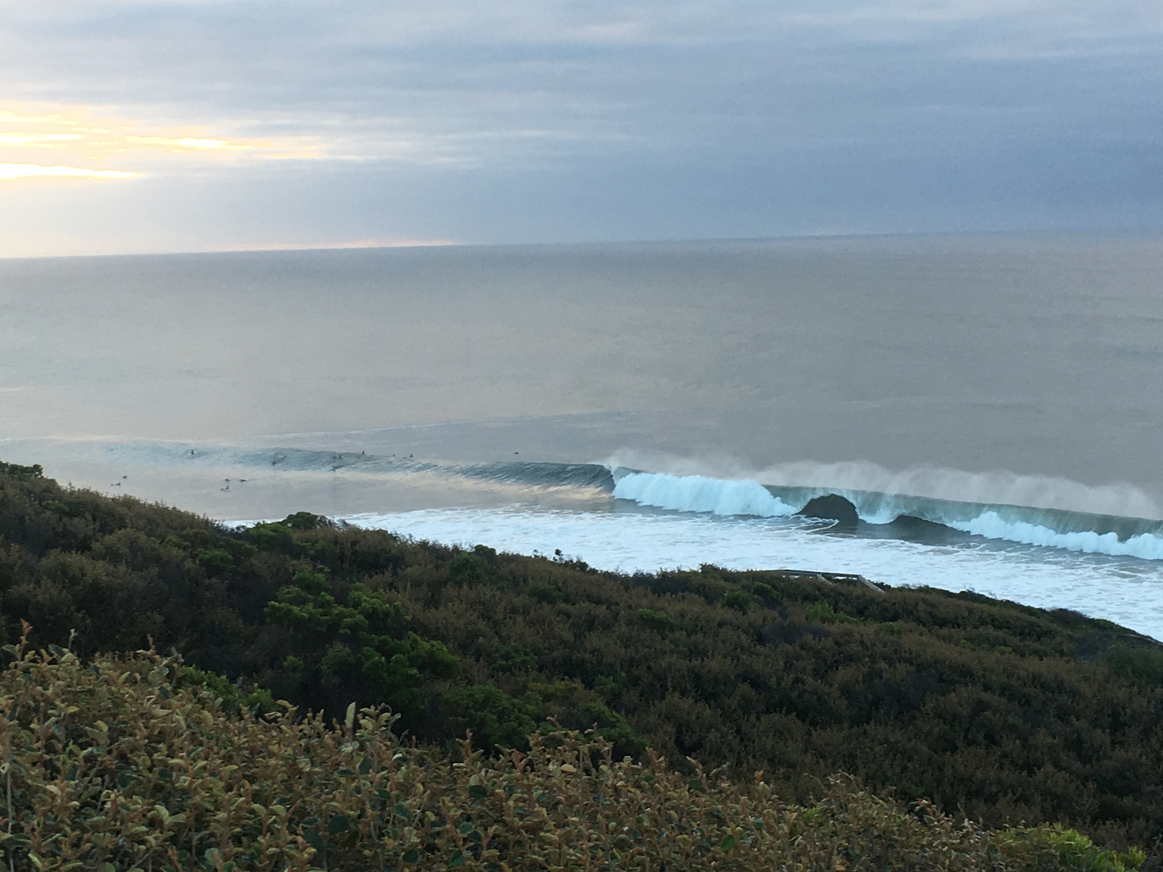
A large pumping S/SW groundswell across the Surf Coast yesterday, generated by a severe low that developed south-west of us on Wednesday. This was the end result of a deep cold pool off the WA coast interacting with a moisture laden inland surface trough on the border with South Australia.
The swell was a little tricky to forecast due to the low dipping south-east away from us, but generating a significant fetch of severe-gale to storm-force winds. In any case it was great to see the swell punch above its weight under offshore winds on the Surf Coast (image thanks to Anthony Burke).
This morning the swell is back to 3-4ft on the Surf Coast and clean again, while more variable winds east of Melbourne are creating clean conditions but with a bit of leftover bump and lump.
A secondary pulse of strong long-period SW groundswell is due this afternoon, produced by a secondary strong polar front moving through our swell window the last couple of days. This should keep strong 4ft sets hitting the Surf Coast, with 6ft+ sets across the Mornington Peninsula beaches though with afternoon sea breezes.
Today’s Forecaster Notes are brought to you by Rip Curl
This weekend and next week (Dec 23 – 29)
This afternoon's strong pulse of SW groundswell is expected to peak overnight and ease slowly through tomorrow as a morning NW breeze creates great conditions on the Surf Coast again. We should see clean 3-4ft surf, with 5-6ft+ waves on the beaches east of Melbourne. Our more variable breeze possible for locations east of Melbourne looks less likely with that tendency to the west.
Sea breezes will develop through the afternoon, creating bumpy conditions.
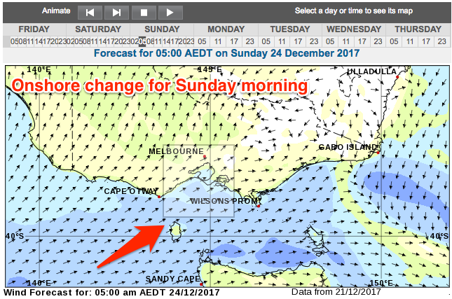 Our onshore change for Sunday looks to arrive during the early hours of the morning and with this, the odds of an early offshore around Torquay looks much less likely. We'll see gusty SW winds across all locations, possibly W/SW around Torquay if we're lucky.
The front bringing this change will also deliver a kick in reinforcing mid-period SW swell with the Surf Coast due to build back to 3-4ft through the day and 6ft on the Mornington Peninsula.
A slow drop in size should be seen through Monday though with poor S'ly tending S/SE winds, improving for selected locations east of Melbourne with an E'ly Tuesday. The swell will be easing from 2ft to maybe 3ft on the Surf Coast and 3-5ft on the Mornington Peninsula.
By the time winds swing true offshore from the N/NE Wednesday the surf will only be small on the exposed beaches, easing from 2-3ft. The Surf Coast will be tiny.
Longer term we're due to see some very inconsistent long-range W/SW groundswell building Thursday afternoon and peaking Friday. This will be generated by distant frontal activity through the southern Indian Ocean, with no major size expected at all. Winds will swing to the west as well, with won't favour the exposed beaches.
Some better and closer frontal activity is likely mid-late next week, generating some better W/SW groundswell for the weekend/New Year, but more on this Monday. Have a happy and safe Christmas!
Comments
Want to look at our crystal ball and speculate what time the swell will hit the Mornington Peninsula today?
I finish work at 1 and tossing up whether I should be heading straight down to watch the swell in come in.
Nothing at Cape Sorrell yet.
It should be arriving any minute across Cape Sorell, and the period has upticked slighltly, but not a definitive increase as of yet.
If it arrives in the next hour, it should be starting to show after you finish work.