Fun swell for the weekend

Victoria Forecast by Craig Brokensha (issued Wednesday 6th December)
Best Days: Surf Coast keen surfers Friday morning, Sunday Surf Coast, both regions Monday morning and Tuesday morning
Recap
Workable waves across both coasts yesterday morning with some straight SW groundswell and cross-shore winds, coming in at 2-3ft at magnets on the Surf Coast and 3-5ft to the east.
This morning the swell has dropped back, with a poor quality SE windswell being the dominant energy on the Surf Coast with average winds.
Today’s Forecaster Notes are brought to you by Rip Curl
This week and weekend (Dec 7 - 10)
Tomorrow morning will be clean across most of the Surf Coast with a NW offshore, but the SW swell will continue to fade along with the SE windswell leaving 1-1.5ft sets. The Mornington Peninsula is likely to be around 2ft+ but bumpy and average.
Our new mid-period W/SW swell for Friday is still on track, generated by a weak front pushing up towards WA the last couple of days.
No major size is due off this front though, with 2ft sets at its peak across most spots on the Surf Coast, up to 2-3ft at 13th Beach when it peaks through the middle of the day afternoon. The Mornington Peninsula should reach 4-5ft on the sets, but W/SW winds will create poor conditions, W/NW for a period early on the Surf Coast.
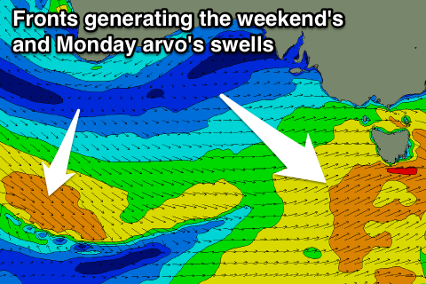 Moving into the weekend and our strengthening polar front and secondary low combo have both weakened.
This isn't ideal but winds are now looking better for these two swells.
The first swell will be generated by a strengthening frontal system late in our swell window Friday evening and Saturday.
A broad fetch of strong W/SW winds should produce a mid-period SW swell that's expected to build through Saturday afternoon, peaking Sunday morning.
We should see consistent 2-3ft waves across most breaks on the Surf Coast Sunday morning, more towards 3ft at magnets, easing through the afternoon. The Mornington Peninsula should offer surf more towards 4-6ft Sunday morning.
A morning NW wind will favour the Surf Coast before sea breezes kick in, while Monday morning should see variable winds as we fall between swells.
Now, instead of the secondary low forming in behind this initial front, we'll see a weaker front generating a pre-frontal fetch of W/NW winds on top an active state.
A fun reinforcing SW swell should result, building Monday and reaching 3ft on the sets across the Surf Coast again, with 4-5ft+ waves on the Mornington Peninsula. This will however be with afternoon sea breezes.
Tuesday is looking better as the swell eases under a light morning N/NE breeze, but we'll have another look at this Friday.
Comments
You know Craig, this run of poor surf has forced Gary to start looking for cultural experiences to fill the time.
Gary’s calendar has been a little lacking lately, aside from the annual trip to schoolies, so you can imagine his excitement to find that not only was there an event last weekend at the Melbourne Showgrounds, it was on the same date as the former Stereosonic and seemed to be right up Gary’s alley.
Well, public service announcement to anyone planning on going next year, the event was certainly not what the name promised.
Gary should have known that something was up based on the misspelling of the event name (!), but aside from the prevalence of people wearing raincoats there was nothing else that Gary would associate with attending a so-called-Gizzfest.
Caveat Emptor!
Are you guys privy too what models willy weather run with?
Willy has sat noon for 5 knot north where as your models have it at 19 knot westerlies. How can there so much divergence ?
Nah I don't sorry, but pretty sure just GFS. Nowhere in the Victorian vicinity will see a 5kt N'ly on Saturday, not sure where that's coming from.
Willyweather seems to use one of BOM's weather model products, not sure exactly which one.
See https://www.willyweather.com.au/terms.html
One thing that is really nice about their wind is they provide actual reported wind at the nearest weather station. Always hard to say which of these models are going to be - or have been in the past - most accurate.
"One thing that is really nice about their wind is they provide actual reported wind at the nearest weather station."
We have AWS readings on Swellnet too (on the surf report pages).