Fading surf ahead of some new swell for the weekend

Victoria Forecast by Craig Brokensha (issued Monday 7th August)
Best Days: Surf Coast Tuesday morning, east of Melbourne Wednesday afternoon, Surf Coast Saturday and Sunday
Recap
Decent Surf Coast waves Saturday with a mix of swells coming in around 2-3ft with offshore winds. Sunday morning should of held around a similar size, easing ahead of a late increase in new swell. The surf actually backed off to 1-2ft, with each pulse of long-range energy, mixed in with W'ly windswell hard to discern late last week.
The surf remained small ahead of today's stronger W/SW groundswell. This swell was another tricky number, generated by a strong but northward tracking polar turned mid-latitude storm.
It's come in with some good but varied size across the Surf Coast with most exposed reefs seeing 3-5ft sets, but with a bit of wobble and rawness to it. Conditions have been clean most of the morning but an onshore change is now moving through with poor conditions due into the afternoon.
This week and weekend (Aug 8 - 13)
This morning's W/SW groundswell has already peaked with Cape Sorell maxing out just after midnight and from here we'll see the swell starting to ease off, dropping through tomorrow and further Wednesday.
The Surf Coast may see the odd stray 2-3ft set early tomorrow with surf in the 4ft range on the Mornington Peninsula with W/NW winds persisting all day. Get in early on the Surf Coast for the most size.
 Wednesday morning will become small to tiny on the Surf Coast but the beaches to the east should provide inconsistent 3ft sets into the afternoon with improving conditions as a morning NW breeze tends lighter N'ly.
N'ly winds should persist Thursday but unfortunately there's no new swell due with the Surf Coast becoming flat, while the Mornington Peninsula will be tiny.
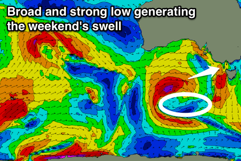
Moving into the end of the week and weekend, a deepening and broad mid-latitude low moving slowly in from the west will aim a series of gale to severe-gale W/SW fetches through our swell window while moving across us Friday.
With this we should see moderate amounts of W/SW swell developing for Saturday. Before this some W'ly windswell will build Friday but with terrible and gusty W/NW winds for the Mornington Peninsula, while the Surf Coast won't see any real size.
Saturday morning is looking to come in around 4ft range on the Surf Coast at this stage and 6-8ft on the Mornington Peninsula with persistent W/NW winds, but with such a dynamic system we'll have to provide running updates over the coming week.