Varied options for a surf to end the week, great swell Monday

Victoria Forecast by Craig Brokensha (issued Wednesday 2nd August)
Best Days: Beaches Thursday, Surf Coast Friday onwards, great later Sunday and Monday
Recap
Good clean waves across the Surf Coast most of the day yesterday with sets to 3ft, while the Mornington Peninsula was a little too large early, becoming more manageable into the afternoon.
This morning the swell was smaller, back to 2ft on the Surf Coast with light variable winds from the N'th, while the Mornington Peninsula offered fun clean sets in the 4ft range. Winds will freshen from the E through today as the swell eases ahead of a late increase in new long-period SW groundswell.
This week and weekend (Aug 3 - 6)
The swell due later today was generated by an intense polar low earlier this week. Satellite observations picked up a tight fetch of storm-force winds and with this we're likely to see sets pushing above 3ft at the peak of the swell on the Surf Coast, but this is overnight tonight.
The swell should kick later today with sets due to reach 3ft by dark on the Surf Coast and 4-6ft on the Mornington Peninsula, peaking overnight and coming in at a similar size tomorrow morning on both coasts.
The beaches will be best again tomorrow with a moderate to fresh NE tending E/NE breeze.
Later in the day Thursday some new W/SW groundswell is due, coming in around a similar size to the morning SW energy.
This swell, which will persist through Friday and Saturday morning is being generated by an elongated pre-frontal fetch of gale to severe-gale W/NW winds. This fetch is moving slowly east from the south-east Indian Ocean and should keep exposed breaks on the Surf Coast coming in at 3ft on the sets Friday and the 5ft range on the Mornington Peninsula.
An approaching front will swing winds back to the NW though, favouring the Surf Coast over locations east of Melbourne.
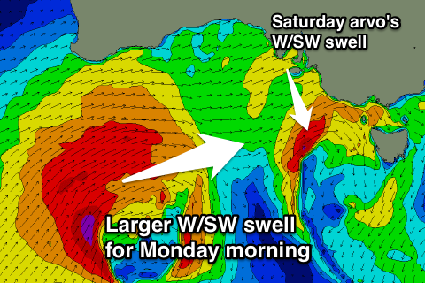 This front is forecast to slip south-east across us Friday evening and early Saturday morning, projecting a fetch of W/SW gales through our western swell window.
This will kick up an afternoon increase in mid-period W/SW swell but I can't see it getting much above 3ft on the Surf Coast and 5-6ft on the Mornington Peninsula at this stage. With this front we'll see fresh and gusty W/NW tending NW winds, favouring the Surf Coast again.
The swell is due to drop back into Sunday morning as we fall in between frontal systems.
Our stronger polar front projecting towards us from the Indian Ocean mentioned in Monday's notes is now expected to take a more northern track.
This is a little less than ideal with the resulting groundswell coming in a little more west.
Still in saying this we'll see a fetch of gales projected through our western swell window from today through the end of the week, with stronger severe-gales generated as the front nears us over the weekend.
The WSW groundswell from this system is now due late Sunday and likely after dark, with some building mid-period energy due instead into the afternoon.
At this stage we're looking at building sets to 4ft later in the day on the Surf Coast and 6ft+ on the Mornington Peninsula with gusty NW tending W/NW winds.
Monday morning is the pick with a peak in W/SW groundswell to 4-5ft+ on the Surf Coast and 8ft on the Mornington Peninsula with fresh NW winds.
Longer term moderate levels of W/SW swell are due to persist most of next week, but more on this Friday.