Funky week ahead of a large swell later Sunday/Monday

Victoria Forecast by Craig Brokensha (issued Monday 31st July)
Best Days: Both coasts Tuesday morning, protected spots east of Melbourne Wednesday and Thursday, Surf Coast Friday onwards
Recap
Average surf Saturday with a strong offshore wind and tiny leftover swell from Friday.
Sunday was a little disappointing. While the morning's swell was west, the strength of the storm linked to it off the WA coast was such that I thought it would override this slightly, but alas the Surf Coast saw small and inconsistent 2ft waves with bigger sets to the east.
A larger and better aligned W/SW swell for the late afternoon provided more size with sets reaching an inconsistent 4-5ft across the Surf Coast (though swallowed by the late high tide) and 8ft+ on the Mornington Peninsula, a touch under expectations. Cape Sorell registered some great numbers, but the west in the swell was the main limiting factor. Conditions were great all day on the Surf Coast though with fresh to strong NW winds.
Today the W/SW groundswell was on the ease with clean waves in the 4ft range across the Surf Coast and larger bumpy waves to the east, best in protected spots.
This week (Aug 1 - 4)
Our current W/SW groundswell will continue to ease over the coming days, with tomorrow the pick as morning variable winds from the N'th create clean conditions across most spots. Winds will swing more E into the afternoon, so get out through the morning on the Surf Coast for easing inconsistent 2-3ft sets across magnets and 4-5ft waves on the Mornington Peninsula.
Wednesday will be smaller and a moderate to fresh E/NE wind will create poor conditions on the Surf Coast as a low stalls off the southern NSW coast, with peaky but workable 3ft sets on the Mornington Peninsula.
Some new inconsistent W/SW groundswell is due into Wednesday afternoon, peaking Thursday morning, generated by a strong polar frontal system that's currently south of WA. A split fetch of strong W/SW winds and severe-gale to storm-force polar W/SW winds will generate a mix of W/SW and SW groundswell for the afternoon, building to 3ft by dark on the Surf Coast and 4-6ft on the Mornington Peninsula.
Thursday morning should reveal similar sized sets but E'ly winds will continue to favour locations east of Melbourne. Later in the day more variable breezes may be seen and this will be along with another new W/SW groundswell from a broad and strong fetch of pre-frontal severe-gale W/NW winds in the Indian Ocean.
This fetch will move slowly east while making a few transformations, producing a couple of W/SW groundswell pulses from later Thursday through Friday.
The swell should peak through Friday again in the 3ft range on the sets across the Surf Coast with 5ft waves on the Mornington Peninsula and winds will swing back to the NW with an approaching mid-latitude front.
This weekend onwards (Aug 5 onwards)
Similar sized waves are due Saturday morning across both coasts but the mid-latitude front will push through, bringing strong W/NW winds.
 Through Bass Strait we'll see strong W/SW breezes and this should kick up some new swell for the afternoon ahead of a larger and more significant W/SW swell through Sunday and Monday.
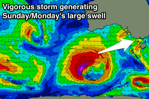
This swell should be produced by a vigorous polar storm forming in the Heard Island region mid-week, projecting east-northeast towards us through the end of the week and into the weekend while producing a fetch of severe-gales.
A large powerful W/SW groundswell should result, building Sunday and peaking Monday morning, but we'll have a closer look at the specifics on Wednesday.
Comments
Stacks of lines still pouring through TQ this arvo.