Good surf Saturday and again Monday

Victoria Forecast by Craig Brokensha (issued Friday 21st April)
Best Days: Dawn east of Melbourne Saturday, Surf Coast all day, possibly early Surf Coast Sunday, both coasts Monday, Surf Coast Tuesday and Thursday
Recap
Great conditions across the beaches on both coasts yesterday, and selected reefs on the Surf Coast with easing 3-4ft sets, and 5-6ft waves on the Mornington Peninsula.
Today the swell was smaller and back to 2ft on the Surf Coast with a NE breeze, while the Mornington Peninsula saw clean 3-4ft surf.
Later today some new W/SW groundswell is due and winds will swing more N'ly, keeping most conditions clean, with improving conditions on the Surf Coast. Sets to 3ft are due on the Surf Coast, with 4-6ft sets on the Mornington Peninsula.
This weekend and next week (Apr 22 - 28)
This afternoon's increase in W/SW swell is expected to ease back through tomorrow from 3ft at swell magnets on the Surf Coast and 4-5ft+ east of Melbourne. Winds have changed a little but the Surf Coast looks great all day with a NW tending W/NW breeze.
The Mornington Peninsula should see a dawn N'ly, tending more N/NW late morning and more onshore into the afternoon. Therefore go the early east of Melbourne.
Our two stronger W/SW groundswells due late Saturday and more so Sunday are still on track. A couple of strong back to back frontal systems fired up towards WA over the last couple of days, generating fetches of gale to severe-gale W/SW winds over an active sea state.
 The first swell is due to arrive on dark Saturday, peaking Sunday morning, with the secondary swell arriving late morning and peaking through the afternoon.
The first swell should be in the 2-3ft range on the Surf Coast Sunday morning with 4-5ft sets on the Mornington Peninsula, with the better swell for the afternoon increasing to 3-4ft and 6ft respectively.
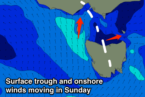
Conditions Sunday are now looking average as a surface trough drifts in from the west, bringing S/SW-SW winds. There is a slight chance for an early W/NW'ly around Torquay if the trough stalls, so keep an eye on the local wind observations around dawn.
Monday is now looking better as the trough weakens Sunday evening resulting in variable tending locally offshore breezes, light into the afternoon. Sunday's swell will ease with 3ft waves on the Surf Coast and 4-5ft+ sets to the east.
A low point in swell is expected Tuesday morning with offshore NW winds, favoruing the Surf Coast.
Later in the day some new SW groundswell is expected, but this will be along with a SW change that will also kick up moderate amounts of mid-period SW swell for Wednesday.
The groundswell will be generated by a relatively strong polar frontal progression, with a front shedding off this and projecting up and into us later Tuesday.
A building mix of onshore swells should reach 3-4ft+ on the Surf Coast and 6ft+ on the Mornington Peninsula Wednesday afternoon, but with S/SW winds. Another approaching front should swing winds back offshore from the W/NW Thursday with some decent easing size.
Longer term there's plenty more swell on the cards but winds are the limiting factor, with a a slow moving ridge of high pressure expected to move in after a change Friday. More on this Monday though. Have a great weekend!