Small swells with easterly winds

Victoria Forecast by Craig Brokensha (issued Monday 2nd January)
Sign up to Swellnet’s newsletter and receive the Victorian Forecaster Notes and latest news sent directly to your inbox. Upon signup you'll also enter the draw to win a surf trip to P-Pass for you and a mate. It doesn’t get much easier so click HERE to sign up now.
Best Days: East of Melbourne mid-late morning Wednesday, east of Melbourne Thursday morning, both coasts Saturday morning, east of Melbourne Sunday
Recap
Poor surf Saturday with tiny waves on the Surf Coast and bumpy conditions to the east. A small, inconsistent W/SW groundswell for Sunday started to show with clean small 1-2ft sets on the Surf Coast and workable 3ft+ waves on the Mornington Peninsula with a light variable breeze but slight bumps.
Today was poor again with an onshore wind and small weak windswell.
This week and weekend (Jan 3 - 8)
Another poor surf day is expected tomorrow with onshore S/SW tending S/SE winds and a continuation of tiny to poor surf.
Our new SW groundswell for Wednesday is still on track, generated over the weekend by a good fetch of pre-frontal W/NW winds, south-west of WA.
This swell will be inconsistent and should arrive later tomorrow, peaking Wednesday morning to 2ft to possibly 3ft at swell magnets on the Surf Coast and 3-4ft on the Mornington Peninsula with 5ft bombs.
Dawn will be poor with a moderate to fresh E/SE breeze, but mid-morning winds should swing E/NE and then NE late morning before sea breezes kick in.
So the best time to surf will likely be mid-morning east of Melbourne.
Some small SE windswell will also be present on the Surf Coast through the morning but only to 1-2ft or so.
Into Thursday similar conditions are due as the swell eases from a small 2ft on the sets across the Surf Coast and 3ft+ on the Mornington Peninsula.
Friday morning is expected to start out tiny, but into the afternoon and more so Saturday a new SW groundswell is expected.
 An increase Friday afternoon will be generated by a pre-frontal fetch of NW gales, with Saturday's pulse produced by a better aligned post-frontal fetch of W/SW gales more through our southern swell window.
SE winds look to create average conditions Friday, but Saturday a morning N/NE'ly is due to develop with 2-3ft sets on the Surf Coast and 3-5ft waves on the Mornington Peninsula.
Sunday will be clean again across both coasts but small and best on the exposed beaches across the state.
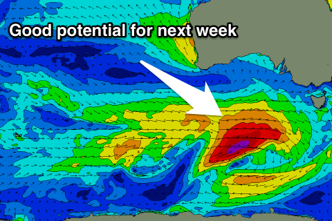
Longer term we've got some good looking W/SW groundswell on the cards for next week as a strong and sustained polar frontal progression fires up under the country. This progression looks to generate moderate amounts of swell, but more on this Wednesday.