Solid swells building Thursday, best early Friday with light winds

Victoria Forecast by Ben Matson (issued Monday 24th October)
Best Days: Tues: morning offshore with good waves at open beaches. Thurs/Fri: large building swell with OK winds Thurs, becoming excellent early Fri. Sat/Sun: more strong swell (smaller than Thurs/Fri) with good winds for the open beaches Sat, and the reefs Sun.
Recap: Not a lot of quality over the weekend with onshore winds and moderate swells Saturday that built into Sunday but weren’t really big enough for any major quality at sheltered locations. Winds and swells have eased today.
This week (Oct 25th - Oct 28th)
Tuesday looks pretty good across most coasts.
The new swell expected to build today (mentioned in Friday’s notes) will be easing in size, but early morning should offer fun - though very inconsistent - 2-3ft waves across the Surf Coast that’ll be best suited to the open beaches under a straight northerly breeze. We may see a NW wind tendency into the afternoon, which will favour the reefs.
Exposed beaches east of Melbourne will see much larger surf, anywhere between 4ft and possibly 6ft early in the morning, and conditions should improve quite a bit from today. Surf early for the best waves here as the NW breeze into the afternoon could put some unwanted side wobble into the lineup. Expect smaller surf through the afternoon.
A passage of several weak fronts crossing the coast on Wednesday and early Thursday will maintain mainly westerly winds across the state, though we should see early W/NW winds throughout the Surf Coast. Tuesday’s swell will have eased back to 2ft in Torquay and 3-5ft east of Melbourne but it’s hard to imagine there’ll be a lot of quality on offer on Wednesday.
Thursday is shaping up to be reasonably good.
Craig’s Friday notes detailed a significant Southern Ocean low tracking through out far swell window over the weekend, and the models have maintained this system very well in the latest runs. The leading edge of the expected long period groundswell (18+ seconds) is expected enter Bass Strait around dawn on Thursday, so the morning will probably start off undersized across most surfing regions, ahead of a strong increase throughout the day, peaking overnight Thursday.
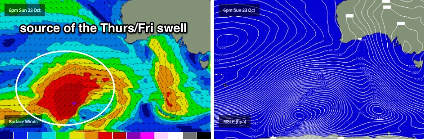
This swell will mainly favour the Surf Coast, though we could see some fun late options inside Western Port. The last of several weak fronts traversing the region in the early hours of Thursday morning should clear to the east during the morning, allowing light variable winds to settle across the Surf Coast however open beaches (east of Melbourne) will still experience some residual bump at first (no major problem anyway, as wave heights will quickly push above these beach’s thresholds).
What’s more likely is that winds will veer back to a light to moderate SW throughout the day - enough to put a few wobbles into the lineup across the Surf Coast, but probably not enough to totally wreck conditions. Most Surf Coast breaks should see an increase into the 4-5ft range throughout the afternoon, and some of the region’s more reliable swell magnets may see a handful of 6ft+ bombs late in the day.
East of Melbourne, Thursday’s upwards trend should max out in the 8-10ft range late afternoon across the open beaches, but we should see fun 3ft surf across Western Port breaks to finish the day.
What I like most about this swell event is that the system responsible for it weakens only slowly through its passage under the continent, which means the backside of the peak - on Friday - will ease only slowly in size. And with a weak ridge of high pressure creating light variable winds and sea breezes, Friday morning should deliver some excellent waves across the coast. This is the pick of the forecast period for me.
East of Melbourne should maintain strong 8ft to almost 8-10ft surf at times on Friday morning, with good 2-3ft surf in Western Port on the more favourable parts of the tide. Expect slightly smaller surf after lunch.
Across the Surf Coast, most breaks should hold inconsistent sets around 3-5ft, with possibly a few stray bigger bombs early morning at the swell magnets (as per late Thurs). Only a very slight easing trend is expected into the afternoon, of which conditions may become ruffled with a moderate afternoon sea breeze.
This weekend (Oct 29th - 30th)
The lovin’ doesn’t stop on Friday.
Whilst all of the late-week action is happening, another series of fronts will have reared up south-west of WA, generating new W/SW tending SW swell for Victorian waters.
These fronts look a little smaller, a little less vigorous and aimed a little more west in alignment - so resulting surf size across Victorian beaches will be smaller than the late week pulse - but the good news is that a broad ridge of high pressure across the eastern states will shunt these fronts to the south, leaving the Victorian coast with mainly light winds out of the northern quadrant - possibly NE at times on Saturday but more N’ly through Sunday.
At this stage we’re looking at a building trend through Saturday that should reach 3ft+ at most of the Torquay reefs, a little bigger across the Bellarine Peninsula (4ft+) and then larger again near 6ft+ across the Mornington Peninsula and Phillip Island into the afternoon. Sunday’s size should hold in and around this range, but I’ll evaluate the particulars more close in Wednesday’s update.
Next week (Oct 31st onwards)
The Southern Ocean looks like it’ll remain pretty active into the first half of next week too, with strong suggestions for more frontal system to impact the state early in the week, delivering plenty of swell - but probably a lot of onshore wind too.
There’s also a suggestion for a large blocking high to develop behind these fronts, which suggests the second half of next week and the following weekend could see a return to smaller, more benign conditions - so I’d recommend making the most of the strong swells later this week and weekend.
See you Wednesday.
Comments
...time to pull out the tinny/jet-ski and shoot a visit to the Melbourne heads eh?
You will have a few friends.
Couple of lil' peelers at Lorne this afternoon.
Cleaning up nicely across the MP this arvo.
WHERES MY SORRELL??
Ben
How confident are you in that building trend for Saturday?
Thanks
read the notes properly. look forward to tomorrows notes.
Thanks