Saturday is the pick of the forecast period

Victorian Surf Forecast by Ben Matson (issued Friday 23rd January)
Best Days: Sat: solid groundswell with light variable winds at most coasts. Sun: brief window at dawn on the Surf Coast or at Flinders. Wed: small but good quality SW groundswell, and possible good winds - best for exposed coasts.
Recap: Small swells on Thursday - not enough size for the Surf Coast but ideal for the open beaches east of Melbourne where winds went light and variable through the morning and remained that way for most of the day until a gusty S’ly change hit around quarter to five (gusting 43kts!). Winds then temporarily swung northerly overnight but a shallow SW change is pushing across the region (winds are currently light but will probably freshen through the middle of the day). A very late pulse of new swell is expected (not yet visible on the Cape Sorell buoy), although it will peak tomorrow.
This weekend (Jan 24 - 25)
Note: forecast notes will be brief this week as Craig’s away
We’re still on track for some good waves this weekend.
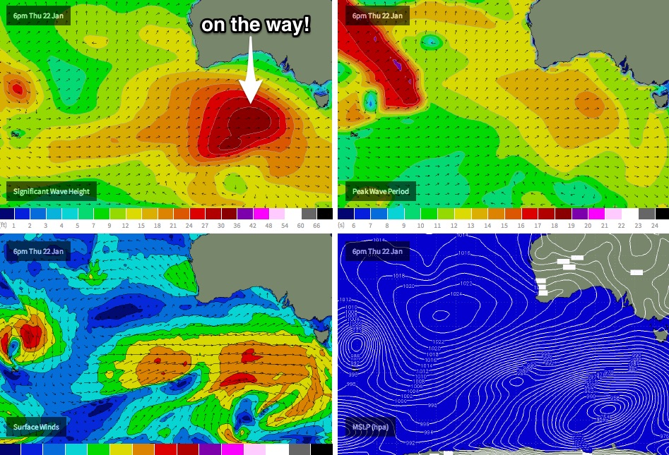
A strong series of Southern Ocean lows and fronts are barrelling their way through our swell window, and will provide a great round of surf to the state on Saturday. Today’s onshore winds will clear to the east, and a high pressure system will create light variable winds and sea breezes across most coasts.
Wave heights should reach somewhere in the 3-5ft range west of Melbourne, with 6-8ft surf east of Melbourne (expect good small waves in Western Port, around 2-3ft on the push of the tide). A peak in size is expected around the middle of the day.
Note: light variable winds means exactly that - from any direction. So don't be surprised if we see a 10kt easterly develop at times. It shouldn't spoil the surf too much, but needs to be factored in at some spots (ie Surf Coast reefs, Western Port) as it can cause some ridging up the face.
On Sunday, a gusty SW change is expected to push through early and it’ll cause problems just about everywhere. There’s still a chance for an hour or three of early W/NW winds at dawn, which would favour the Surf Coast the best (as the swell will probably still be too big for the open beaches east of Melbourne) however there should be early waves at Western Port or (more likely) Flinders. But you will need to be very quick.
Wave heights will be a little smaller than Saturday and once the onshore kicks in you’ll probably struggle to find anything notable at those sheltered locations that enjoy these winds - small clean waves are possible though.
Next week (Jan 26 onwards)
No major changes to the long term forecast. Sunday’s swell will ease from Monday onwards, and winds will rapidly ease from the SW and swing SE.
A regional blocking pattern will develop across our broader swell window during this time, which means we’re unlikely to see any notable swell events for some time. However, as mentioned in Wednesday's notes, a deep polar low is expected to form near Heard Island today, and then scoot along the ice shelf over the weekend - setting up a small but decent SW groundswell around Wednesday.
This swell looks like being only small to moderate in size (i.e. best suited to exposed coasts) but of should have good quality when the sets do arrive - although, they will be rather inconsistent.
The wind outlook is a little unsure, as we’ll be under the influence of a large high in the Bight - which would ordinarily steer winds around to the southeast. However a developing system off the East Coast is throwing some uncertainty to the wind forecast, as the models are suggesting it’ll move slowly southwards which could create a troughy pattern over Central Victoria, and therefore swing the airstream more favourably to the east or north-east.
Either way it’ll be a swell best suited to the open beaches east of Melbourne. Tune in Monday to see how the winds are shaping up.
Comments
A quick update: forecast notes won't be updated until tomorrow (due to the Long Weekend). As for the next few days though - no major changes to the notes above - Wednesday should have some good options at open beaches east of Melbourne as a small long range groundswell pushes through, and winds swing to the east throughout the day (may be a few leftover SE bumps to begin with). Otherwise no major swells on the horizon for the long term.