Forget this week, the weekend's gonna pump

Victoria Forecast by Craig Brokensha (issued Wednesday 14th January)
Best Days: Saturday on the Surf Coast, Sunday morning on the Surf Coast, Monday morning east of Melbourne, Tuesday morning east of Melbourne
Recap
A small but fun and building SW groundswell under offshore NE winds provided good waves east of Melbourne most of yesterday with peaky beachy waves across the Surf Coast.
Today an early onshore change was ruined any chance for a surf and a weak windswell is expected to build through the day.
This week (Jan 15 - 16)
Today's change will whip up a junky and weak SW windswell this afternoon that is expected to peak overnight and start easing tomorrow as the system pushes off to the east.
Winds will be generally poor and fresh from the W/SW but Torquay should see an early W'ly with an easing and weak 2ft+ wave. It won't be worth the drive from Melbourne though with the low quality swell and onshore winds developing mid-morning.
Friday will be much cleaner but tiny with a strengthening NW'ly ahead of a W'y change towards the afternoon/evening.
This weekend onwards (Jan 17 onwards)
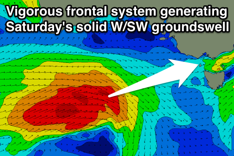
The weekend's swell has been upgraded, with a vigorous and strengthening polar frontal progression, now forecast to come in a lot stronger than predicted on Monday. The evolution of this system will be related to a strengthening node (peak) of the Long Wave Trough across the state, with a fetch of gale to severe-gale W/SW winds being projected perfectly towards us through our western swell window.
This front will push across us Friday evening, with a moderate to large sized W/SW groundswell peaking in its wake on Saturday.
The Surf Coast should offer 4-5ft waves with the odd bigger set at its peak during the middle of the day/afternoon at swell magnets, while the Mornington Peninsula looks to come in at 8ft+.
Winds will be best for the Surf Coast and fresh and gusty from the W/NW through the morning ahead of a shift to the W/SW.
The backside of the swell event into Sunday and Monday will be drawn out due to a secondary weaker and slower moving frontal system on the tail of the initial storm, continuing to aim a fetch of strong to gale-force SW winds through our swell window Saturday before sliding east through Sunday.
This should see the swell swinging more SW through Sunday, easing from 3-5ft on the Surf Coast and 6-8ft on the Mornington Peninsula. Winds look good for the Surf Coast again with a morning W/NW breeze Sunday, swinging SW during the late morning and more S'ly into the evening.
Monday will be improving east of Melbourne but far from perfect as a ridge of high pressure moves in from the west, swinging winds back around to the E/NE as the swell continues to ease from 3ft on the Surf Coast and 6ft across the Mornington Peninsula beaches.
Tuesday will be the day to hit up the beaches east of Melbourne with a smaller easing swell from 3-4ft under fresh to strong offshore N'ly winds.
Longer term we may see some renewed W/SW swell energy from Thursday next week, but we'll look at this again on Friday.
Comments
Hey Craig I thought I posted a q but must've closed the screen. Anyway, basically just wanna know if it's gonna be victory at sea for 200km west of the surf coast on Sat? The last similar system, was too unruly where it was big enough to surf and too small to surf where it was protected, so frustrating! I would've thought that EVERYwhere was gonna have 2ft groundswell at least...
Well it's not going to be big or south enough for one location Mitch, and everywhere else will be marginal, as you say, small and sheltered or just too hard work. Only place to be this weekend is the Surf Coast.
OK cheers, I honestly don't have one location in mind, more of a general question. Also am fishing for any sort of 'cronulla is rarely offshore when other areas are onshore (or whatever it is)' type of rules of thumb :p. You know, synoptic vs local, gfs vs local, etc.
Ah yes, well that's the beauty of the Otway ranges under a general west to south-west flow, it always steers winds to the west-northwest downstream across the Surf Coast (unless there is a lot of strength to the south-wester).
Further west, not so.
Hey craig
Do you think there will be any surf at westernport this weekend or during next week
Thanks again Craig. It was friggin more white than blue off the cape today, reminded me of that fake snow at Christmas! Yet only 1-2 pitiful feet piddled past to paddle on to. Crisp temps too! Snake Coast seems like a more appropriate name right now!
Oh and winds in morning were as you would expect elsewhere, land breeze was at work, as minor as it was.