Punchy NE swell Saturday with offshores ironing out the bumps

Sydney, Hunter and Illawarra Surf Forecast by Ben Matson (issued Friday 9th September)
Best Days: Sat: punchy but improving NE swell as NW tending W'ly winds iron the bumps out. Should be really good through the arvo, if a little smaller. Sun: small clean combo of easing NE swell and building S'ly swell, best in the arvo.
Recap: Thursday’s expected southerly groundswell provided good, if somewhat 3ft sets to south facing beaches during the day as northerly winds freshened about the coast. Today we’ve seen the south swell almost completely disappear but a building NE swell has increased from 2-3ft to 3ft+ throughout the day. Local N/NE winds have been only moderae in strength, which is a little lighter than expected (this is unusual; normally when this happens the local short range swell falls short of expectations).
This weekend (Saturday 10th - Sunday 11th)
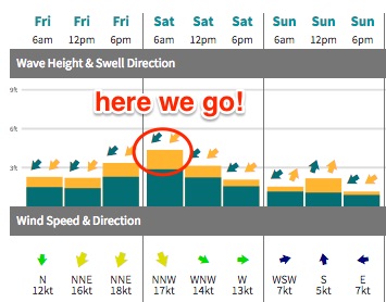 Some good news for Saturday surfers: we’ve had a slight upgrade in the forecast. This is due to two factors: (1) a slight delay in the timing of the offshore wind change, and (2) a minor strengthening of the immediate fetch off our coast.
We’re now looking at moderate to fresh NW winds enveloping the coast in the early hours of Saturday morning (rather than overnight), which means N/NE gales should persist within our immediate swell window until just after dawn. This means that surf size should maintain a peak from early morning until early afternoon, before then easing mid-late afternoon.
If there’s a downside, it means that the early session on Saturday may still see some leftover surface wobble from the overnight northerlies. However, they’re currently below forecast expectations and this near-shore trend may also persist overnight (lessening the wobble effect).
NE facing beaches across the Sydney region should see 3-5ft sets on Saturday morning, but we’ll see smaller surf north of the Central Coast (i.e. up into the Hunter region), and south facing beaches everywhere will be smaller in size.
Conversely, the South Coast should see slightly larger surf (i.e. 4-6ft north facing beaches) on Saturday owing to a slightly longer fetch length.
Winds should swing from the NW to the W across all coasts during the day so surface conditions will only continue to improve into the afternoon.
Sunday looks smaller but nice and clean with lots of potential. Saturday’s NE swell will be easing steadily, though the aforementioned upgrade characteristics means we may see a little more size early Sunday morning than was tipped on Wednesday (i.e. 2ft+ at NE facing beaches instead of 1-2ft). However this source will definitely be easing during the day.
Of much greater interest is an small but intense low forming east of Bass Strait, in the lee of Saturday’s change. This has been slightly upgraded in the latest model runs though also slightly delayed, which means we’ll see marginally bigger wave heights but probably not arriving (in Sydney) until the afternoon (peaking late in the day).
Interestingly, our surf model isn’t picking up this swell very well, however I think we’ll start from a small base through the early morning, before building to 2-3ft+ at south facing beaches into the afternoon. It is however a small, flukey system - that is expected to travel a little more quality than desireable through the swell window - so we probably won’t see a wide distribution of surf from this source, just reliable south swell magnets and that’s about it.
Fortunately, winds are looking pretty good on Sunday, light and variable with sea breezes.
Next week (Monday 12th onwards)
The Southern Ocean frontal passage for the forecast period has been stalled a little, but we’re still looking at plenty of small but long period S’ly energy for the second half of the week. The leading edge of the first swell may appear on Tuesday afternoon but Wednesday is a safer bet, as is Thursday and Friday with several follow up swells. Very intermittent 2-3ft sets are likely from this source at south facing beaches.
Prior to this, Monday and Tuesday are looking at mainly small residual swells with light winds Monday and early Tuesday ahead of a gusty SW tending S'ly change later Tuesday (earlier on the South Coast), as a weak troughy pattern off the Far South Coast consolidates into a tight closed low. However it probably won’t be until Wednesday until it aligns within our swell window (though Tuesday afternoon should see a late, rapid increase in short range SE swell across the South Coast).
The close proximity of this system to our coastline means it’s hard to have confidence in the size and timing, but Wednesday is on track for some punchy 4-6ft surf at south facing beaches. However, winds are also expected to kick up from the S/SW as an associated front wraps around the low and clips the coast. So surface conditions probably won’t be great.
As this low tracks out into the Tasman Sea it’s possible we’ll see a return SE swell from its southern flank (around Thurs/Fri) but this is still a very long time away. Otherwise, the only other notable swell source for the long term period is a local NE windswell late in the week (not too dissimilar to what we’re seeing today) as another front approaches from the west.
Have a great weekend, see you on Monday!
Comments
NE winds maintaining strength at Norah Head all afternoon is a great sign. Only light to moderate N/NE on the Northern Beaches though; surface conditions look quite workable.
Was a little raw at first light but seems to have cleaned up nicely over the last few hours; seems a little smaller now though.
Early morning at Queensie:
Just a few minutes ago:
Fun waves all over the place.....if a little inconsistent and remember your wetsuit, the water temperature is way down!
Not one great day from this swell yet. The winds are bullshit.
Work the winds and you'll find great waves. Saw lots of good surf today!
Are we still on track for 2-3ft on Sunday?
Scored fun 3-4 maybe occ 5ft dawn this am. Winds were pretty tricky at a few spots but cleaned up real fast! By 630 it was glassy. Few fun banks around to. Dunno what all these barns are doing in 2mm/boardies bloody chilly.
Tomorrow arvo still on track Ben? Cheers.
Looks like the new S'ly swell is kicking in nicely across Southern NSW.