Large stormy NE swell due to peak on Sunday

Sydney, Hunter and Illawarra Surf Forecast by Guy Dixon (issued Monday 30th)
Best Days: Tuesday, Thursday and Friday mornings, hopefully Monday morning.
Recap:
Two pulses of south swell provided plenty of good options across the NSW coast over the weekend, with Saturday offering solid sets over 6ft along the Illawarra and South Coast, more so in the 4-5ft range along the Sydney coast. Sunday still had great options on offer, with sets in the 3-4ft range at south facing beaches, larger across the Hunter.
Quality was virtually never an issue with offshore breezes persisting virtually all day each day. Only this afternoon have we seen wave quality drop as winds swung south.
This week (Tuesday 31st - Friday 3rd):
Following a particularly active week, the southern swell window looks to settle down in the coming days. However, a few weak trailing fetches pushing up through the Tasman Sea will maintain workable energy throughout the working week.
South facing beaches should still be offering sets in the 2ft+ range on Tuesday morning, with the Hunter highlighting this energy and offering a touch more substance. A slight period pulse is due on Wednesday from the southeast, generated by a small intensification in the southerly airflow moving up through the Tasman.
Options should hold in the 2ft+ range on Wednesday, before pulsing slightly on Thursday to the 3ft range at south facing beaches. This more substantial pulse is likely to be generated by a southerly intensification off the west coast of New Zealand on Tuesday and should be the last decent pulse out of the southern swell window before easing throughout the remainder of the week.
The Hunter will gain a touch more size off this swell once again due to the exposure of the coastline, while the South Coast can expect less size.
Take advantage of Tuesday morning’s southwesterly airflow as winds look to tend southeasterly throughout the day and stay that way into early Wednesday, possibly tending variable mid-morning. Quality will be ordinary once the wind swings, with very few options for a decent wave, if any.
Otherwise, winds look to tend west/southwesterly once again on Thursday morning and Friday morning, before eventually swinging southeasterly leading to a drop in quality.
Poorly aligned polar fronts are likely to continue, although the nature of these storm tracks looks particularly zonal, so only background energy is likely to fill in across exposed south facing locations throughout the remainder of the forecast.
This weekend (Saturday 4th - Sunday 5th):
Not to worry however, models are serving up a particularly interesting set up leading into the weekend.
At first, a coastal trough looks to deepen from around Wednesday and Thursday before interacting with a deep inland trough which is expected to move over central NSW on Friday. The interaction between this deep inland trough and a weakening ridge will cause the pressure gradient to increase from late on Friday afternoon.
A large and elongated northeasterly fetch is likely to extend towards the islands of the South Pacific, increasing to a peak in strength and size on Sunday.
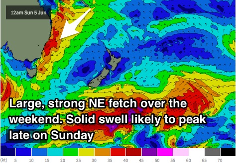
The resultant swell is due to build steadily throughout Saturday to the 3-5ft late in the day, becoming large and stormy by Sunday afternoon. This far out, I'm hesitant to put a size on it, although at this stage it’s looking like double digits.
Quality is likely to be a significant limiting factor over the weekend however, with a fresh to strong northeasterly breeze dominating Saturday, increasing to a strong to gale-force northeasterly flow on Sunday. The latest model runs are suggesting winds to tend offshore and clean things up for the late session on Sunday, but again, the situation is dynamic to say the least so nothing is set in stone.
Next week (Monday 6th onward):
You’ll have better luck finding a wave on Monday as winds swing offshore. Size wise, the swell will still be very big, with the northern flank of an embedded low steering a westerly component airflow over the NSW coast.
Comments
"Sunday still had great options on offer, with sets in the 3-4ft range at south facing beaches"
Even on east facing beaches with a southern headland protecting it!
Seriously interesting synoptic forecasts though, will watch this one all the way through, and then see what it has done to one of the biggest sand build-ups at the local that I can recall for a while.