Fun run of inconsistent S/SE swell

Southern Tasmanian Surf Forecast by Craig Brokensha (issued Monday July 3rd)
Best Days: Every day this period until Sunday
Features of the Forecast (tl;dr)
- Easing SW swell tomorrow
- Inconsistent SE groundswell tomorrow with a stronger pulse Wed, easing Thu ahead of a final pulse Fri
- N tending variable winds most days
Recap
The weekend provided plenty of surf but with average conditions Saturday, coming in at 2-3ft across Clifton, cleaner yesterday and holding 2-3ft.
This morning a reinforcing pulse of swell has maintained 2-3ft sets with great winds all day.

Good size this aftenoon
This week and weekend (Jul 4 - 9)
Today's swell is due to ease back through tomorrow, smaller Wednesday but background levels of inconsistent S/SE-SE groundswell are due to keep Clifton active through the week.
More exposed locations will offer bigger sized sets as well.
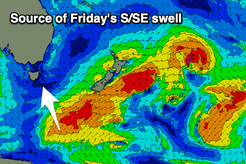
The source of this groundswell is persistent winds out of the S/SE-S/SW to the south and south-west of New Zealand, at the base of a large, broad Southern Ocean gyre sitting just east of New Zealand.
Clifton looks to be an inconsistent 1-2ft through tomorrow, with Wednesday's strongest pulse of groundswell likely to offer 2ft to possibly 3ft sets (bigger down the Arm), easing slowly from a similar size Thursday ahead of one final pulse Friday back to 2ft to occasionally 3ft.
Winds will be favourable through this period and offshore from the northern quadrant each morning with variable afternoon breezes.
Saturday looks to see stronger N/NE winds, easing through the day as the swell starts to ease, W'ly Sunday.
From Sunday we're expected to see some new W/SW swell energy filling in thanks to a pair of strong mid-latitude frontal systems pushing in from the west. This looks to be the start of an active westerly swell and frontal regime which we'll look closer at on Wednesday.