Strong W/SW swells this period and plenty more surf next week

Southern Tasmania Surf Forecast by Craig Brokensha (issued Monday 4th March)
Best Days: Thursday morning, Saturday morning, Sunday morning
Recap
Not too much size Saturday morning with clean conditions but tiny 1ft+ sets. The swell eased through Sunday, tiny to flat today.
Today’s Forecaster Notes are brought to you by Rip Curl
This weekend and next week (Mar 2 - 8)
The surf will remain tiny to flat through tomorrow but our new W/SW groundswell for Wednesday and Thursday is still on track.
Over the weekend a strong and distant low generated a fetch of severe-gale to storm-force W'ly winds, and the storm is currently weakening south of WA while still generating a fetch of W'ly gales in our western swell window.
The swell will fill in Wednesday, but be very west in nature with inconsistent sets to 2ft to occasionally 3ft across Clifton. Unfortunately the remnants of the storm will move across us Wednesday bringing a SW change before dawn.
 Thursday will be clean with a NW offshore and easing fun 2ft+ sets.
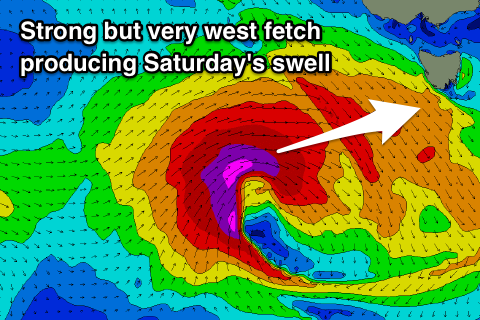
Last week the models were divergent regarding the formation of a secondary low, but they've come into alignment and we're due to see a larger W/SW groundswell developing for the weekend.
The low will form south of the Bight and in our western swell window Wednesday evening, with a fetch of severe-gale to storm-force W/SW winds projected through our western swell window.
A large though very west, long-period groundswell should be generated, building Friday afternoon and reaching 3ft by late in the day but with onshore SW winds, peaking Saturday morning though easing steadily. Clifton should see 3-4ft sets and a NE tending N/NE breeze ahead of SE sea breezes.
Sunday will be much smaller with easing 1-2ft sets under offshore N/NW tending W/NW winds.
Longer term the outlook is very active into next week as a strong node of the Long Wave Trough develops across the south-east corner of the country, directing a series of strong Southern Ocean storms through our swell window. More on this Wednesday.