Average weekend; slightly better next week

South East Queensland and Northern New South Wales Surf Forecast by Ben Matson (issued Friday 17th October)
Best Days: No great days. Late Mon/Tues and maybe Wed for a small long range east swell, but it'll be very inconsistent at best.
Recap: Decent south swell across exposed parts of the Northern NSW coast on Thursday with early light winds and sea breezes. Much smaller in SE Qld. Fading south swell in all areas today although SE Qld seems to be picking up a small E/SE swell.
This weekend (Oct 18-19)
Nothing too much to get excited about this weekend.
A strengthening ridge across the Queensland coast will drive freshening S/SE winds across the Gold and Sunshine Coasts, and wave heights will remain small - just some residual south and east swell from today, plus some low quality S/SE energy originating from the ridge. Set waves will be biggest at south facing beaches but they'll consequently be wind affected.
Similar winds will influence the Northern NSW coast on Saturday, but they'll become confined to the Far North Coast on Sunday, resulting in an improvement across the Lower Mid North Coast for Sunday morning. Unfortunately, by this time there won't be much leftover surf - just a foot or two of mixed swells at exposed beaches.
There's an outside chance for a brief window of light winds north of Coffs Harbour (and through to SE Qld) on Sunday but without any notable swell in the water it's not worth beelining for. As such, expectations should be kept pretty low all weekend.
Next week (Oct 20-24)
A gusty southerly change is due to reach the Lower Mid North Coast sometime mid-morning on Monday, before it advances north during the day, reaching the North Coast mid-late afternoon. The timing is still a little unsure right now; we may not see the change reach the Far North until after dark, and in fact it may very well stall south of Byron, and not push over the border at all.
In any case Monday's waves will be dictated by small residual swells and mainly light to moderate winds from the northern quadrant ahead of the change. These winds are unlikely to be sufficiently strong enough to generate any meaningful short range NE swell, so Monday's surf prospects remain low.
The fetch trailing Monday's change is not expected to be very strong nor very well aligned within our swell window, so wave heights won't become very large through the middle of the week. Tuesday should see a better quality south swell fill in throughout the day - probably after lunch - but it'll only favour south facing beaches in Northern NSW, with inconsistent 2-3ft sets at best (very little energy will make it north of Byron). This southerly energy will have originated from a secondary fetch southeast of Tasmania and will therefore be inconsistent when it arrives in Northern NSW.
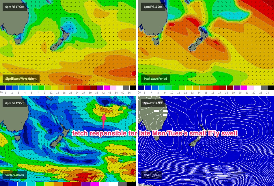
However, of more interest to us is a small E'ly swell expected to arrive later Monday, ahead of a peak through Tuesday before easing Wednesday. This swell will have originated from an impressive fetch developing SE of Fiji at the moment (see chart below).
The latest model guidance has pushed this fetch further east (i.e. away from the Australian coast) than previously forecast, and the large travel distance will result in very inconsistent sets. However, exposed beaches in most areas should pick up 2-3ft at the height of the swell (probably Tuesday). Keep an eye on the surf cams on Monday afternoon though as the leading edge is due in then and there's a chance that surf size could punch above current model expectations. Winds are a little unsure at this stage as models are suggesting we'll see another weak ridge push across the SE Qld region (which would favour semi-exposed points), however I'll take a closer look at this in Monday's notes.
Otherwise, the rest of next week is still looking at a persistent coastal troughy pattern, with local fetches likely to contribute small short range energy for desperate surfers. I'll have more info on this on Monday.
Comments
Qld surfers... May I suggest making the most out of this small to average east swell..... Things look very grim after it fades..... Very very grim..... So scoop it up as best you can...
OK.. S'ly change into Port Mac around 11am. Hasn't hit Coffs yet but strangely winds swung from an early NW to the SE at 9:30am, then E/NE at 10:30am.
Yamba still light NE and Byron moderate to almost fresh NE (having been light most of the morning). So at this stage there's a possibility that the S'ly change may not even reach the North Coast (BOM still have it pushing "through to the Queensland border by Monday evening", but I'm not quite so certain).
Of more importance is a patient wait for the arrival of the small long range east swell this afternoon (due to peak tomorrow). Winds are looking pretty average for the most part anyway but I'm mainly curious on how much size we'll see from such a distant storm.
Was easily chest to shoulder East swell between Burliegh and Currumbin this morn.
Hmm, wonder if that's it? Buoys don't really show any major trend over the last few days. I'm looking for a spike in period to signal the leading edge but it's unlikely to be well defined.
Ben, it's not forecast to fully fill in until tomorrow afternoon is it? Forerunners at best arriving after dark tonight.
Our Goldy models has 0.4m @ 12.4 seconds from the east (94) at 6pm today. So yeah, only forerunners but if the swell is running ahead of schedule, and if the leading edge is reasonably defined (which I'm not very confident on, but have no way of verifying in advance) we could see an appreciable kick in the last few hours of the day.
That being said I'm only expecting 2ft to very occasionally 3ft from this event, with extremely long waits between sets. So the "appreciable kick" is all relative.
0.4m@12.4......gotta be well ahead and well above forecast to get your 2-3ft come close of play today Ben!!!
You're model is forecasting 0.9m@11.6 come lunch time tomorrow and that's only forecast to be 2ft, so to get to 2-3ft I'm assuming your model would need to be around 1.1-1.2m@11-12 sec or so.....that's 3 times above what it's currently forecast for 6pm today......how much above forecast are you expecting by close of play today??
And SC and Ballina reports looked around 2ft this morning already, so I'm not sure how much appreciable "kick" you'll see in the swell come this arvo anyway? (Agree swell period will "kick" on the wave buoys).
I'm not really expecting much above forecast expectations (I had a peak on Tuesday in the 2-3ft range).
But these east swells are not often resolved very well by the models (there's been a couple of similar systems under-forecast this year) so I'm keeping an open mind. Just curiosity more than anything else - there's absolutely no way to have any firmer idea than we currently do until it starts to fill into the coast.
I'm questioning if the models have also overcooked this long range E'ly swell forecast for later this week as I can't see it being 2-3ft from the current WAM forecast?
The fetch is a damn long way away!!!
OK, the southerly hit Coffs at 1:30pm, currently gusting 22kts. Still light NE at Yamba and moderate N/NE at Byron.
Gold Coast buoy just picked up 13.5 seconds out of the east. Should be the leading edge.
Meanwhile, fresh S/SE winds hit Yamba at 4pm and Evans Head at 4:30pm (S'ly) but Byron is still NE (actually light E/NE now).
No mention of the initial pulse on the weekend from the same system when it was closer.... Note chart above..... Mark Pridmore documented east swell on sunny coast sunday am 3 foot....... Swell source was thurs'..... System then drifted east, with subsequent tailing off of swell.... System then strengthened... Pulse in water now....
Nah I reckon that was mainly from a local fetch SD. Goldy was 1-1.5ft on the weekend and a scan of buoy data showed the swell to have a lot of south in its direction (surfcams didn't show anything notable on the Goldy or North Coast either).
Well' agree to disagree on this one, Ben.... Pointed out to Don and FR this system ages ago, and a weekend east swell for the sunny coast... Goldy wasn't that much in play...... Sunny coast to southern Barrier reef..... Pure east swell....
Note swell direction here;
No local fetch evident..... only this system here;
7 to 8 second period, size, direction, and arrival time all correlate.....
SD, I had a small east swell in the weekend forecast too. Just didn't think much of it, and didn't go into detail because of generally below average surface conditions.
Friday's notes (above) had: "wave heights will remain small - just some residual south and east swell from today, plus some low quality S/SE energy originating from the ridge".
Wednesday's notes had: "Sunday morning... will include the arrival of a small east swell generated by a distant E'ly fetch developing north of New Zealand. At this stage I don't think we'll see much more than a couple of feet at best."
Monday's notes had: "...we'll also see a small E'ly swell perk up throughout theweekend, generated by a slowly developing E'ly fetch north of New Zealand during the second half of this week - however no great size is expected from it (maybe some inconsistent 2ft+ sets at exposed beaches, but very slow)."
And the previous Friday - nine days in advance - had this: "Long term (Oct 18 onwards). Looks like we’ve got some moderate trade swell for the long term as our far eastern swell window falls under the influence of a broad, slow moving high pressure system. It’s unlikely to be an epic swell generating system but should nevertheless supply plenty of surfable options through the long term period, in addition to anything else that may form in the Tasman Sea."
As for the 'local source' off the ridge (as I mentinoed before) - check out this ASCAT pass from Friday night.
It shows a narrow but reasonable 20kt fetch aimed exclusively into the Sunny Coast (and further north), and not the Gold Coast (there is no fetch aimed into anywhere south of Moreton).
Plus the supporting SE fetch further east which would also favour the Sunny Coast over the Gold Coast.
Not definitive, but certainly reasonable evidence to support my claim.
Cheers, Ben.. Thanks for your in depth response.... I think the first mention of this tropical system was in "Extended period of mediocrity ahead" - 6/10..... I pointed out a potential system to mick... At that stage, it looked more like a repeat of the system mick lucked whilst in NZ, with east coast NZ firing and a sneaky ese swell making it past the northern tip of NZ for SEQ........ But as you and I both followed its developments, it formed more to the north..
I still don't think that ascat map was the swell source... I actually think it was responsible for the wobble...
I think this was the source of sundays 3 footers at 7 to 8 seconds.... The leading edge of the fetch ese of New Cal...
Gonna have to agree to disagree on this one. There's no way (IMO) we'd see 3ft sets from that kind of fetch.
Fair enough, mate... keep in mind the region was fairly active, and stretched all the way out to here..
Wasn't the best ascat pass for my theory..... Done and dusted anyway...... Here comes the flat spell..... Cheers.....
Yes, that's the fetch that generated the east swell that arrived late Monday and peaked through Tuesday. A 20-30kt fetch positioned between 170-150E on Thursday couldn't have generated a swell for the weekend.
What doesn't quite add up for mine is the period... swell at 7-8sec from 1200+miles? Looked over a couple sea height and swell decay tables and 3.89ft (1.185672 metres) of swell is a generous estimate. That's roughly 1.95ft surf by the old 1/2 swell = surf, or 1-2ft as a guess if I saw HSig 1.2m @ 8sec from ESE on the buoys... maybe 2.5ft considering direction.
I'm more talking about the area not caught by ascat, mitch - 171ish x 23 to 28..... If you look at the pass I posted with New cal in the map, you see a fetch extending into the area not picked up.... around the 175 line..... Now to the west, at around 167 x27, and 166 x 23, you can see some 20k scuds, again both coming out of that area the ascat pass did not pick up.... I can only assume the 169 - 175 x 23 -28 was a region of 20k east northeasterlies, with good scattering of 20 25k ene in the 172 - 174 x 23 -26.......
Didn't the wave buoys late Monday and more so into Tuesday pick up 12-13sec period? Or are you talking about Sheepio's weekend swell?
Good question, Don..... I'm talking about sunday.. Mitch ?????
But being a lazy guy re' sunday, I just used the old stormsurf calculator...... It's spot on..... http://www.stormsurf.com/page2/papers/calculator/calc.shtml
15/10 - 16/10 - 20 to 25k produces 2 to 2.5m seas.... That equates to 9 foot "seas".... (not swell)...... 9 foot seas at 171/26 on late 15/10 - 16/10/14 with a destination of 153/27s (sunny coast) would arrive on sunday , at 2 1/2 foot, 8ish seconds....
But hey.... We aint talkin' 10 foot perfection..... Just a bit bored today ;)
So how did a fetch over a thousand kilometres away generate an easterly swell that was supposedly picked up on the Sunny Coast but not the Gold Coast or Far Northern NSW? (surf reports had little size, buoy data had little size or trend, surfcam visuals confirmed little size in the water).
A swell originating from such a distant, undefined fetch (ie no central point where core wind speeds are focused) should have at least provided a broad spread of swell. As we saw on Tuesday.
It was picked up, Ben but not to the extent of Sunny coast to fraser.... Note your swell graph for Goldy above... Also note daily report for Sunday re' goldy.....
Haha Sheepy you got be kidding its a two foot swell. Focus on the real deal like where am I going to find some double overhead waves the next two weeks???
Ahhh mickey boy... You have been hereby sentenced to a full spring and early summer on the sunshine coast.... ;)
At the end of your sentence, in early December, you will realize how a 2 to 3 foot swell amongst the 4 months of lake like flatness and northerlies is like a sanity saver.... lol
I have to go up there for a new store setup sometime over the next month, so I am watching and waiting for a decent wave. Apparently its pretty good there this morning ie 2.5 foot. Maybe I should lower expectations.
Hell yeah... I'd lower it down to limbo dancing ;)
Much like fitting tiny comments into here, haha!
How tiny a comment will it go?
Dunno
My sentence began same day Oscar Prestorius began his. 1-2 foot is fun again, its just a mind set you have to change
Mick, the only hope I can see is a bit of a "dry low" over inland NSW/Qld next Thurs/fri week...... problem is that the high east of Australia is piss weak, and no real good infeed of warm pacific moisture over the NNSW QLD coast..... There seems to be a bit of moisture action on the west side of this low (around Southern SA) and an ok infeed of cooler air, but the eastern side of the system doesn't look like it wants to play... Random storms around SEQ, but not enough warm moist air to get an interaction with the colder western flank..... Things may change.. If that high ends up being stronger.....I'll keep a watch out, but don't get your hopes up...... Vicco and west Tassie may be the go this coming week.... Cheers, bro.
I heard there was acrew that went to Martha's last Monday 13th but haven't heard if it was good. This was the day after last weekends Southern Ocean Swell. Did you hear anything Sheepy?
Martha's! That swell was nowhere near big enoug to get it good and proper!
But it got a lot bigger Monday when the SW came in didn't it? Pretty sure crew flew in Monday
Nah, it was gonna be solid, but the low weakened, more junky windswell if I remember correctly. Not 100% on that but.
geez it would be on tomorrow....its huge
Yes, I took note of your chat and the report on Sunday...
Initially, I'm was surprised that a swell of 7-8sec could travel so far. So I worked backwards and took the more generous figures from tables...
- Rounded 14ft @ 8.5s to 15ft at 8... taken from table at 25kt winds over 400 miles for 42 hrs.
- Roughly 1200 miles to 172E.
- Swell decay factor from 15ft over 1200 miles is 0.259, making 3.89ft.
- Timing wise, roughly 2 days from NZ Cape Maria Van Diemen + a bit (as a general rule of thumb) gives Sunday arrival...
that E swell is in the water now. Fun enough when the sets come. Size and consistency as f/cast.
Been getting any fish Freeride ?
trying hard. Flathead aren't as thick as they should be, though there are some crocs around, as well as some small GT's on the first of the incoming.
the odd tailor and schoolie off the stones but very hit and miss.
seen some signs of early pelagic action but no luck putting a lure in front of anything yet.
\you?
Flathead, boys, high tide in channel opposite Sth Tweed Sports. Please only take what u need. 9 legal caught, 3 kept in 3 hours, happy neighbours.
good call Dave.
Still too much swell for the tinny most days but when we get out there or off the rocks there's been lots of Cobia and the reef species are starting to come on well- rankin cod, baldchin and NorWest snapper due to the water clearing and the bait schools moving back in.
I love the look of those big flatties. Never caught one myself. Lurkers. Tailor are fun. Was talking to a fella that just got back from Dirk Hartog, tales of tailor that looked like mackys.
got a mate that goes to DHI every year and gets massive tailor.
91cm croc off the wall.
Fuck yeah. On a livey ? That thing is unreal. Keep it ?
Hartog sounds gold. Shame there is no surf.....
nah, big soft plastic. Squidgy whipbait.
release all the big girls, they're the breeding stock.
Been fun waves all week from punchy beachies Mon and today to silky point surf and the Ballina reporter hasn't given one day a pass mark. Poor cunt couldn't recognize a fart in a bath tub.