Plenty of swell to come with tricky winds

South Australian Surf Forecast by Craig Brokensha (issued Monday January 29th)
Best Days: Mid Coast later Wednesday and Thursday morning, South Coast for the keen Thursday and Friday mornings, South Coast Saturday morning
Features of the Forecast (tl;dr)
- Small-mod sized W/SW swell for tomorrow with moderate S/SE-SE winds, freshening
- Moderate sized W/SW-SW swell building Wed PM, easing Thu AM
- Gusty S/SE winds Wed, moderate S/SE Thu AM
- Smaller Fri with moderate S/SE winds in the AM
- Large S/SW groundswell Sat with E/NE-NE tending S/SE winds
- Secondary strong SW groundswell Sun with early NW tending SW winds
Recap
Friday's onshore blow backed off into Saturday morning with cross-shore winds and lumpy surf to 2ft on the Mid Coast through the morning, 4ft across the Middleton stretch with a little window of W/NW winds before the onshores kicked back in.
The Mid was best as the tide dropped and then pushed back in, with sea breezes adding small bumps.
Yesterday was great across both regions with cleaner surf and plenty of swell still to 1-2ft across the Mid Coast and 3-4ft across Middleton.
This morning the swell was down further but hanging in at 1ft to occasionally 1.5ft on the Mid Coast, still 3ft down South on the sets across Middleton. A trough has since brought a S'ly change to the South Coast, creating deteriorating conditions.

Lumpy, full 2ft sets Saturday morning
This week and next week (Jan 30 – Feb 4)
Now that winds have shifted onshore down South, we've unfortunately got a poor run of persistent southerly winds due this week, with only a couple of windows lining up for cleaner surf before a more established south-southeast flow develops next week.
There's plenty of frontal activity and surf due through the period, with it initially being located more favourably in our western swell window before focussing more in our south-western and southern swell windows into the weekend.
On the weekend, a fetch of pre-frontal W/NW winds to the south-west of Western Australia has generated a fun pulse of mid-period W/SW swell for tomorrow.
Tiny waves should continue in the gulf with 2-3ft sets across Middleton but a S/SE-SE breeze will only favour the Mid Coast, bumpy and average down South.
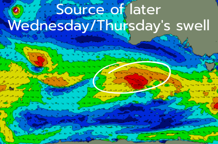
Fresher S/SE breezes are due into Wednesday and a stronger pulse of W/SW swell is due to arrive into the afternoon, peaking overnight and easing Thursday.
The source is a stronger frontal system in the current stream of activity that's moving under the country. A burst of W/NW gales will be generated south of WA today, with the storm strengthening further while passing under us tomorrow.
This will result in a W/SW tending SW swell for Wednesday/Thursday with slightly stronger 1-2ft sets (inconsistent) due on the Mid Coast, while Middleton should offer stronger 4ft sets into Wednesday evening and Thursday morning.
The Mid looks best Wednesday with the S/SE winds holding into the afternoon, with Thursday seeing S/SE winds back off in strength to light to moderate. This will see workable conditions for the keen down South, with similar winds due Friday as the swell continues to ease.
Now, moving into the weekend, a couple of stronger storms are forecast to fire up in the South Coast's swell window, with a strong low due to develop south-west of Tasmania on Thursday. This is currently forecast to generate a fetch of gale to severe-gale SW winds in our southern swell window, producing a large S/SW groundswell for Saturday.

Behind this a secondary, tight low may form south-west of Western Australia, with it being the remnants of Tropical Cyclone Anggrek which is east of Madagascar.
Coming back to Saturday's swell though and Middleton looks to come in at 5-6ft and winds should be favourable out of the E/NE-NE, with the secondary low generating a secondary pulse of strong swell for Sunday.
A SW change looks to move in quickly Sunday though, possibly NW early but we'll have a closer look at this Wednesday. Following the change S/SE-SE winds are expected to set in next week, but check back Wednesday for the latest.