Another large swell to come but with poor winds

South Australian Surf Forecast by Craig Brokensha (issued Wednesday November 15th)
Best Days: No good days
Features of the Forecast (tl;dr)
- Easing swell over the coming days with strengthening S/SE winds tomorrow, moderate E/SE tending S/SE Fri
- Smaller Sat with light-mod E/SE tending fresh S/SE winds
- Large S/SW groundswell Sunday (possibly a touch undersized early) with moderate S/SE winds, strengthening
Recap
Conditions weren’t too bad out across the South Coast yesterday morning with a light to moderate onshore wind and plenty of swell in the 4ft range, bigger today thanks to the arrival of a stronger, larger S/SW groundswell. Conditions weren’t perfect but still good down South this morning with a light E’ly breeze, now deteriorating with a freshening S/SE sea breeze
The Mid Coast has offered a touch more size today but mostly to 1-1.5ft.
This week and weekend (Nov 16 - 24)
The current swell has peaked and is expected to back off slowly over the coming days, with the drawn out fetch of gales slowing the drop in size through tomorrow and Friday.
Easing 4-5ft sets are due across Middleton tomorrow morning, tiny across the Mid Coast and with deteriorating conditions as a polar front pushes up and towards Tasmania.
This will bring strengthening S/SE winds tomorrow creating poor surf, easing and tending E/SE on Friday morning but still very average following a full day of onshore winds.
The weekend isn’t much better with easing surf due on Saturday with light to moderate, morning E/SE winds before fresh S/SE sea breezes kick in.
Our large, long-period S/SW groundswell for Sunday is on track, with a significant polar low due to form south-southwest of the country today. The big question is, will it be a bombing system, dropping the 24hPa threshold in 24 hours? The answer is yes, with EC coming on board and forecasting a drop of around 32hPa within 24 hours.
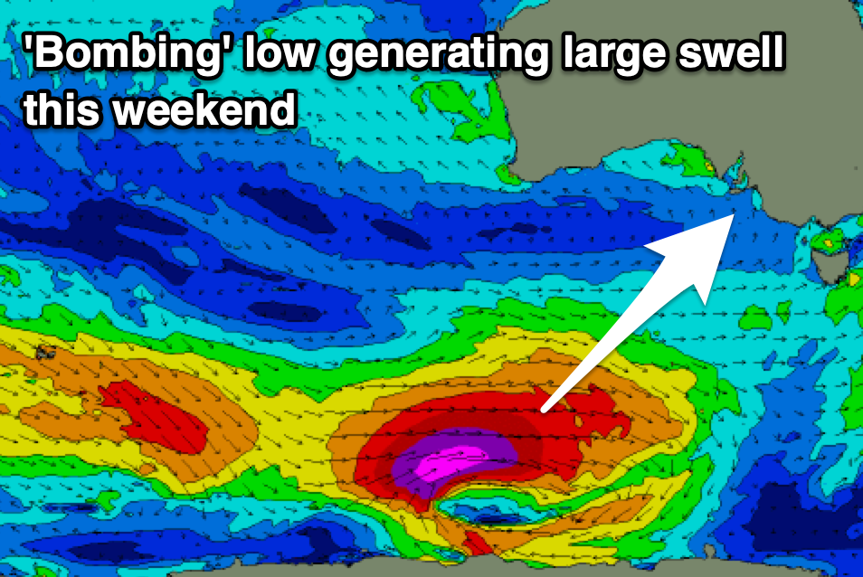
This will result in a fetch of storm-force W/SW winds firing up under the country tomorrow, pushing slowly east and then under Tasmania Saturday morning.
The swell from this system looks to be stronger and bigger than the current swell, arriving Sunday morning and pulsing to a large 6-8ft on the South Coast magnets and 8ft on the deep water reefs. The Mid Coast isn’t due to see any size at all.
Unfortunately winds look to remain poor, moderate out of the S/SE, strengthening through the day.
Strengthening S’ly winds will kick in next week as a new, strong high starts muscling in from the west bringing a poor run of strong S/SE winds and localised windswell to the South Coast as the Mid Coast remains tiny. More on this in Friday’s update though.
Comments
Fuck me I thought La Nina conditions for 3 years was bad. This is worse. No offshores for up to month.
You may as well switch off from expecting anything decent along the South Coast until April.