Varying winds with building surf on the weekend

South Australian Surf Forecast by Craig Brokensha (issued Wednesday August 9th)
Best Days: This morning South Coast, keen surfers both regions Friday morning, South Coast Saturday morning, South Coast Sunday morning, South Coast Monday
Features of the Forecast (tl;dr)
- Building mid-period W/SW swell Thu PM with fresh but easing W/SW-SW winds (W/NW early down South)
- Easing W/SW swell Fri with variable tending local offshore winds and afternoon sea breezes
- Moderate sized mid-period SW swell building Sat, strongest Sun
- Light N/NW tending W/NW winds Sat ahead of a late S/SW change, E/NE tending fresh E/SE Sun
- Easing surf Mon with fresh E/NE-NE tending variable winds
Recap
Great conditions across the South Coast yesterday with easing 2-3ft sets across Middleton and 1-1.5ft waves persisting on the Mid Coast. Sea breezes were weak on the Mid Coast with a little kick to 1-2ft seen through the afternoon, while today the swell is back to 1-1.5ft and deteriorating with freshening N'ly winds.
The South Coast is clean but 2ft+ across Middleton, better on the swell magnets. Expect the size to continue to ease through the day as wind strengthen and swing more N/NW.

Good surf yesterday

Still fun sets this AM
This week and next (Aug 10 – 18)
Tomorrow will be a lay day with the swell reaching a low point on the South Coast as a trough brings W/SW-SW winds (W/NW early around Victor). The Mid Coast will be bumpy and onshore with tiny surf, but some new, weak W/SW swell energy is due to build through the afternoon, generated by the front that's currently moving through the Bight.
Size wise it only looks to hit 1-2ft later on the magnets across the Mid Coast, easing from a similar size Friday.
The South Coast may see small 2ft+ waves across the Middleton stretch, more so towards Goolwa.
Winds will be good for both regions come Friday with a persistent N/NW-NW breeze on the South Coast and E/NE-NE tending moderate N/NW breeze on the Mid, easing later.
Later in the day across the South Coast, the first pulse of new mid-period SW swell from a strengthening polar frontal progression to the south-southwest of Western Australia may be seen, but the weekend is a much more reliable chance for this (though with flukier winds).
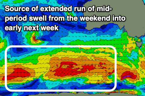
The polar frontal progression is currently quite patchy and not consolidated with fetches of strong W'ly winds being generated through our medium-range swell window.
During today and tomorrow a slight better fetch of gale-force W/SW winds will develop to the south-southwest of Western Australia, projecting slightly east-northeast before weakening and then being followed by a secondary system piggy-backing up through Friday.
This will generate building levels of mid-period SW swell on the weekend, with the strongest pulse arriving late Saturday before peaking Sunday, easing slowly into Monday and Tuesday next week.
Saturday morning looks to be 2-3ft, with the size building later to possibly 3-4ft, peaking Sunday to 4ft+, then easing from 3ft to possibly 4ft on Monday morning.
The Mid looks to be mostly 1ft with the odd bigger one working the favourable parts of the tide.
Winds are a little tricky with a trough moving through but a N/NW offshore is due on Saturday (N/NE on the Mid), shifting W/NW and then S/SW but without much strength down South into the afternoon.
Sunday as the swell peaks looks less favourable with an E/NE breeze down South, shifting E/SE and freshening through the afternoon. Monday looks to play out similar with fresh E/NE-NE winds, easing and tending more variable into the afternoon as a mid-latitude low drifts in from the west.
As the swell eases Tuesday a shift back to W/NW tending W/SW winds looks likely as the low moves east, though the models diverge regarding this.
Longer term a long-range W/SW groundswell is likely later in the week but winds look dicey thanks to incoming frontal activity. We'll have to look at this in more detail on Friday when the models hopefully start to converge.