Fun swells with developing NW winds

Nias, Mentawai, South Sumatra forecast by Craig Brokensha (issued Tuesday 19th October)
Best Days: Exposed breaks from tomorrow (out of the W-NW breeze Friday through Sunday)
This week and weekend (Apr 20 - 24)
Today a new inconsistent S/SW swell should of slowed the weekend's easing trend, but expect wave heights to drop slowly this afternoon, further down into tomorrow under variable winds.
Thursday, Sunday's and later Monday/Tuesday's pulses of swells are all still on track, generated by three back to back polar frontal systems west of Heard Island and south-east of South Africa.
The first swell should fill in Thursday offering inconsistent but good 4-5ft waves across exposed breaks, easing back into Friday.
Into later Saturday and more so Sunday the secondary slightly bigger S/SW groundswell is due, with a peak around 5-6ft across swell magnets, easing later in the day and more so through Monday.
The final pulse of swell for later Monday and Tuesday will be a touch more consistent and a touch more west in nature than the two before, produced by a strong and slow moving polar front currently south-east of South Africa. A fetch of SW gales are being produced through our swell window at a more northern latitude than the storms before it.
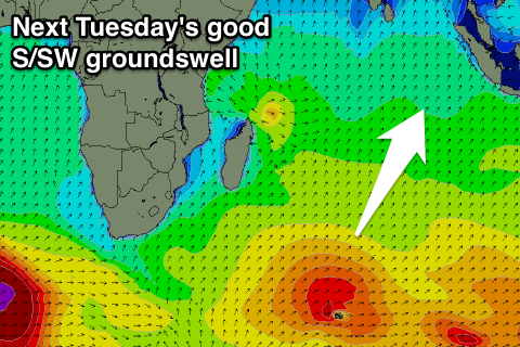 This swell should kick later Monday and peak Tuesday to an infrequent 5-6ft across exposed breaks during the morning, easing into the afternoon and further Wednesday and Thursday.
Coming back to the expected winds, and variable breezes should persist but from Friday through Sunday less favourable and moderate to sometimes fresh NW winds are due. This will favour south-east facing breaks.
Variable winds should develop again Monday, persisting most of next week.
Longer term there's nothing major until the middle of the first week of May, but more on this Thursday.
16 day Mentawai forecast graph
16 day Nias forecast graph
16 day South Sumatra forecast graph