N'ly swell mid-week, better N/NW groundswell for the weekend

Hawaii North Shore, Micronesia and PNG forecast by Craig Brokensha (issued on Tuesday 19th December)
Best Days: Every day over the coming period
This week and next (Dec 20 – 29)
Hawaii: Today's easing NW groundswell will continue to fade through tomorrow, only to replaced by some large N'ly swell through tomorrow and more so Wednesday.
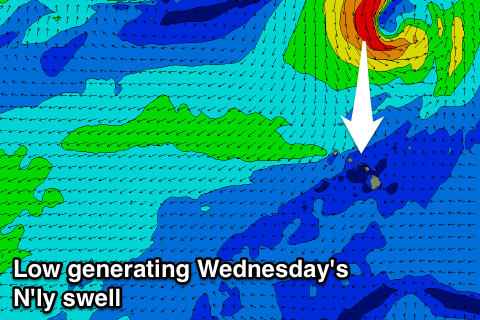 Currently a surface trough squeezing against a strong high positioned to our north is aiming a fetch of strong to gale-force N/NE winds through our northern swell window.
We'll see this trough form into a low, maintaining strong to gale-force N'ly winds to our north before the system retreats northwards later this week.
A strengthening N'ly groundswell will build through tomorrow and peaking Wednesday to 6-8ft+ across exposed breaks on the North Shore though with poor N/NE winds.
A slow drop in swell is then due Thursday and Friday as less than ideal N/NE winds persist.
The weekend is looking better as E/NE trades develop Saturday along with a large new N/NW groundswell.
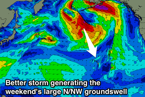
A strong storm is forecast to develop south of the Aleutian Islands later this week, projecting a broad and elongated fetch of gale to severe-gale N/NW winds towards us.
We should see a large N/NW groundswell produced, building through Saturday and reaching 8ft by dark and peaking Sunday morning in the 10ft range.
 Winds on Sunday will be great through the morning, but a SW'ly is due into the afternoon as a secondary low pushing down towards Hawaii interferes with the local trades.
This low is forecast to stall in our north-western swell window while strengthening, aiming a broadening fetch of gale to severe-gale N/NW winds towards us.
An secondary oversized N/NW groundswell is expected to build through Tuesday and peak Wednesday morning in the 12ft+ range though with what looks to be average winds. We'll have to have a closer look at this Thursday though.
North Shore Forecast Graph
North Shore WAMs
Micronesia: Across Micronesia we're looking out for N'ly groundswells to hit the exposed reef passes that are offshore in the E/NE trades. These swells usually originate in the vicinity of Japan, and through this forecast period there's nothing of the sort on the cards until possibly mid-late next week.
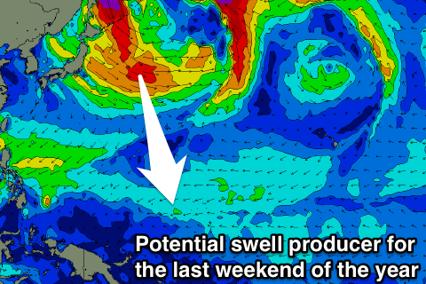 We should see a strong storm forming off Japan, generating a moderate to large sized N/NW groundswell for the last weekend of the year, but we'll keep a close eye on this.
Other than this, we've got a steady supply of E/NE trade-swell due across the region, though with poor and gusty E/NE winds, leaving no decent surfing options.
Palikir Pass Forecast Graph
Palikir Pass WAMs
Papua New Guinea: Current fresh W/NW winds and W/NW windswell are due to ease back through tomorrow, further into the end of the week as a tropical depression in the region weakens.
We'll then see some fun NE trade-swell over the coming week and weekend building through Thursday and Friday to 3-4ft at exposed breaks, before easing temporarily Saturday.
Trades to the east of Micronesia will strengthen and broaden later this week and remain established into early-mid next week, generating some stronger NE trade-swell from Sunday and more so Monday. We should see surf to 3-4ft+ with variable winds from the W each morning ahead of sea breezes.
Comments
Hi Craig Im off to Hawaii next week its been pretty horriable over there so far is
there any sign of the weather and conditions improving as im there for a month
on the nth shore with frothing teenages and family. Thanks mate.
Will have an update today Evo.
Latest notes here: Large N/NW swell this weekend, with an XL swell mid-next week