Small southerly swells

Eastern Tasmania Surf Forecast by Craig Brokensha (issued Wednesday 21st April)
Best Days: Friday and Saturday morning south swell magnets, similar Monday and Tuesday morning
Features of the Forecast (tl;dr)
- Inconsistent S'ly groundswell for Fri, easing Sat with fresh W/NW winds
- Mid-period S swell for Mon, easing Tue with W tending NE winds
Recap
Tiny to flat yesterday while a tiny windswell was seen today following yesterday's change. It'll be gone by this afternoon.
This week and weekend (Apr 22 - 25)
Flukey, that's the key word still for our region over the coming forecast period. But there's a bit more potential surrounding Friday's S'ly groundswell.
Currently a 'bombing' low is generating a fetch that's too far west and north to be within our swell window, but a secondary front pushing over the top of the active sea state generated by the weakening low will generate gale to severe-galeforce W/SW winds south-west and south of us tomorrow.
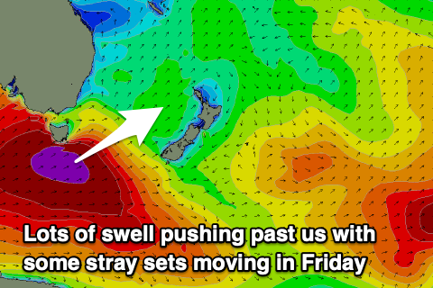 The broad nature and strength of the winds should see some inconsistent S'ly groundswell spread up and into us and offering infrequent 2-3ft sets on the south magnets on the northern end of the coast. Everywhere else will be tiny to flat.
The swell will fade Saturday back from 2ft or so on the south magnets.
Winds look favourable with a gusty W/NW breeze Friday, similar Saturday.
Into Sunday a better projecting and aligned polar front, pushing up into the Tasman Sea should generate some fun mid-period S'ly swell for late Sunday but more so early next week. It's not overly strong but sets to 3ft are likely on the south swell magnets Monday, easing from 2-3ft Tuesday.
Winds look favourable and W'ly ahead of sea breeze, but more on this Friday.