Who doesn't love an upgrade

Eastern Tasmania Surf Forecast by Craig Brokensha (issued Friday 24th July)
Best Days: Protected spots tomorrow, Wednesday through Saturday
Recap
Nothing of note on the weekend or today.
This weekend and next week (Jul 25 – 31)
Upgrade!
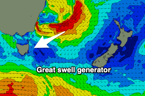 There's been an upgrade on the timing and size of the incoming E/NE groundswell tomorrow and Wednesday, with the infeed of gales on the eastern and southern flank of a deep and powerful low that's dipping south through the Tasman Sea being stronger than forecast on Friday.
The southern NSW coast has come in at a maxing 10-12ft+ and we should see a strong pulse of size tomorrow to 6-8ft across north-east swell magnets on our coasts and holding most if not all of the day.
During this evening and tomorrow the low will weaken, broaden and break down with weakening fetches through our eastern swell window.
This will result in a drop in size through Wednesday but the morning is likely to still be 5-6ft, and then 2ft to maybe 3ft Thursday morning.
Conditions through tomorrow will be best in protected spots with a fresh and gusty S/SE breeze, possibly SSW at times early and late, better Wednesday and W tending NW. Thursday will then see W'ly winds ahead of NE sea breezes.
As the E/NE swell continues to ease late week, a new reinforcing pulse of swell is due to arrive Friday, generated by a surface trough drifting south through the Tasman Sea, squeezing the existing high over near New Zealand.
This will produce a broad fetch of strong NE winds with a low pressure system possibly forming and generating stronger gales.
This swell should build Friday and kick back to 3-4ft+ across swell magnets, then easing from 3ft or so Saturday.
It looks like conditions will remain favourable and then beyond this the outlook goes a bit quiet ahead of a possible S'ly swell mid-next week. More on this Wednesday though.