Mix of south swells, followed by north

Eastern Tasmania Surf Forecast by Craig Brokensha (issued Monday 23rd March)
Best Days: Tomorrow south swell magnets, Thursday afternoon south swell magnets, Friday morning, later Sunday
Recap
Plenty of S'ly swell all weekend but with less than ideal winds and mostly bumpy conditions.
Today we saw cleaner conditions with a light offshore wind, giving into a shallow change.
This week and weekend (Mar 24 - 29)
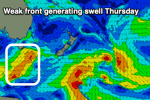
The coming few days are tricky in that there are multiple close-range and more diffracted S'ly swell pulses on the way, but the main thing is that conditions are looking better until a change moves through Thursday.
 A mix of reinforcing S'ly groundswell and short-range energy from a front pushing past us today should provide sets to 3ft on the south swell magnets tomorrow morning, easing through the day with a light W/SW morning breeze, and afternoon E/NE-NE sea breezes.
Wednesday looks smaller and back to 1-2ft or so with a W/SW tending SE and then NE breeze Not ideal.
A weak front moving up past us Wednesday afternoon should produce a new short-range S'ly swell Thursday to 3ft+ or so across the south swell magnets, though winds will linger out of the S/SW in the morning, shifting N/NE into the afternoon. This will be the time to hit the south magnets.
NW to NE winds look favourable for these magnets Friday as the S'ly swell eases back from 2ft or so.
Into the weekend a high moving in from the west looks to be squeezed by fronts under the country, bringing increasing N/NE winds and a building N/NE windswell. It's not due to reach any major size at this stage and come in around 3ft, but keep an eye on the coming updates for any upgrade to this.