Pumping surf tomorrow

Eastern Tasmania Surf Forecast by Craig Brokensha (issued Wednesday 29th August)
Best Days: Thursday experienced surfers, Friday afternoon, Sunday, Monday south magnets
Recap
A poor and weak S/SE windswell through yesterday, replaced by a large and powerful long-period E/SE-SE groundswell today from a deep Tasman Low that's been sitting to our east.
Protected spots have been the only option for a wave though with the size of the swell and average local winds.
This week and weekend (Aug 30 – Sep 2)
Today’s Forecaster Notes are brought to you by Rip Curl
We're currently experiencing the peak in large swell energy from the Tasman Low, with a fetch of severe-gale to storm-force winds registered by satellite yesterday.
Since the low has weakened while retro-grading back towards us, with it due to continue weakening through this evening while starting to push away slowly to the north-east.
This will result in large surf easing out of the SE tomorrow, smaller into Friday.
 We should still see easy 6ft sets across magnets tomorrow morning, dropping steadily and then down further from 2-3ft Friday morning.
Conditions will be much better tomorrow with a W/NW tending fresher N/NW offshore.
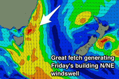
Moving into Friday as the SE swell fades, some new N/NE windswell will be on the build as a strong mid-latitude low moves in from the west.
We'll see a strong and elongated but short-lived fetch of strong to gale-force N/NE winds developing through our swell window early Friday morning, strongest through the middle of the day before pushing away from us into the afternoon with a W/NW change.
This will see the N/NE windswell building through the morning with poor and gusty N'ly winds, swinging W/NW into the afternoon as the swell peaks around 3ft to occasionally 4ft across north-east swell magnets.
Come Saturday morning there's hardly due to be any swell left with clean tiny leftovers on the beaches.
Our new S'ly swells for Sunday and Monday are still on track with a strong cold-outbreak due to push up and across us on the weekend, with a broad fetch of strong to gale-force S/SW winds being pushed up past us Saturday afternoon and evening, persisting Sunday morning.
We'll see a large powerful swell for the South Arm, with weaker energy for us, but still surf to 4-5ft across south magnets though with W/SW-SW winds. Monday looks best as the swell eases from the 4ft range with a light W-W/NW tending NE breeze.
Longer term we're looking at a possible solid N/NE windswell event later next week, but more on this Friday.