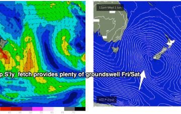
More fronts maintain a synoptic offshore flow (or light winds) for the week and we’ve got plenty of S swell to last the week, albeit at reduced sizes compared to the weekend.
Primary tabs
/reports/forecaster-notes/south-east-queensland-northern-new-south-wales/2022/06/13/another-week-s
freeride76
Monday, 13 June 2022

/reports/forecaster-notes/south-east-queensland-northern-new-south-wales/2022/06/10/s-swell-and
freeride76
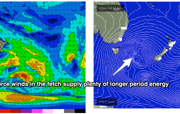
Friday, 10 June 2022
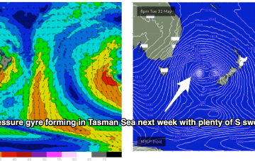
Current ASCAT (satellite wind speed) passes show gales to severe gales extending down to 55S with a tighter core of storm force winds just emerging from behind Tasmania as it tracks NE into the Tasman Sea. The synoptic flow from the fronts and Southern Gyre remains W to W/SW and that will continue all weekend with plenty of wind chill to boot.
/reports/forecaster-notes/south-east-queensland-northern-new-south-wales/2022/06/08/extended-s-swell
freeride76
Wednesday, 8 June 2022
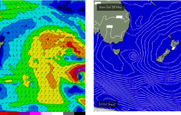
Strong high pressure support from a 1033hPa elongated high in the Bight is providing tight pressure gradients for the multiple fronts spinning off the gyre. That will lead to numerous over-lapping S’ly pulses over the coming week with a general step-ladder effect expected at least through to Mon. A general offshore flow will accompany these pulses as the fronts drive W’ly biased winds across the temperate to sub-tropical East Coast.
/reports/forecaster-notes/south-east-queensland-northern-new-south-wales/2022/06/06/extended-round-s
freeride76
Monday, 6 June 2022
A strong node of the long wave trough is steering fronts into the Tasman Sea while a negative phase of the SAM (Southern Annular Mode) is bringing the southern Ocean storm track into a more northerly latitude, closer to the Australian continent and Tasman Sea. Both those factors will drive a series of strong cold fronts this week, with a step-ladder effect likely as each subsequent front works on an already charged sea state.
/reports/forecaster-notes/south-east-queensland-northern-new-south-wales/2022/06/03/lot-more-southern
thermalben
Friday, 3 June 2022
Using today's results in Southern NSW as a proxy, we should see some solid south swell across Northern NSW on Saturday.
/reports/forecaster-notes/south-east-queensland-northern-new-south-wales/2022/06/01/south-swells
freeride76
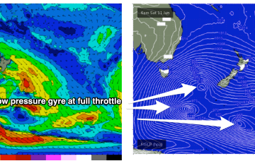
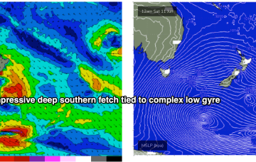
Wednesday, 1 June 2022
Brisk westerly winds and a complex low pressure gyre in the Tasman Sea, with multiple cold fronts and a deep S’ly fetch of gales extending down to 55S have ushered in the first day of Winter.
/reports/forecaster-notes/south-east-queensland-northern-new-south-wales/2022/05/30/wintry-week-ahead
freeride76
Monday, 30 May 2022
Another dynamic week ahead but a bit more straightforwards in the sense that all the incoming swell will be from the S- once the current E swell pulse peters out fully through tomorrow.

/reports/forecaster-notes/south-east-queensland-northern-new-south-wales/2022/05/27/weekend-e-swell
freeride76
Friday, 27 May 2022
Right on cue, as head into the first week of winter, a nice cold outbreak and blast of W’ly winds with accompanying S’ly swells affects the entire East Coast.
/reports/forecaster-notes/south-east-queensland-northern-new-south-wales/2022/05/25/couple-more-days
freeride76
Wednesday, 25 May 2022
Attention will still be focused on the tropics/sub-tropics as a surface low forms at the northern end of the trough off the CQ coast through Thurs/Fri and tracks southwards into the weekend, bringing (another!) rebuild in E’ly swell.
/reports/forecaster-notes/south-east-queensland-northern-new-south-wales/2022/05/23/week-full-e-swell
freeride76
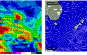
Monday, 23 May 2022
Sub-tropical troughs and the remnants of TC Gina near New Caledonia are maintaining a deep E’ly flow through the Coral Sea while the last in a series of powerful cold fronts are now sweeping up past the South Island of New Zealand with small S to SSE swell pulses to come over the next couple of days from this source.