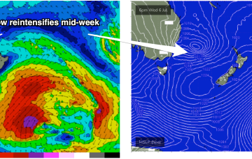
Tasman Sea is looking very, very spicy this week with our current low looking to meander N and E, then S and reintensify later in the week, sending fun-sized swell to the East Coast with mostly favourable conditions in our sub-tropical region.
Primary tabs
/reports/forecaster-notes/south-east-queensland-northern-new-south-wales/2022/07/04/clean-fun-surf
freeride76
Monday, 4 July 2022
/reports/forecaster-notes/south-east-queensland-northern-new-south-wales/2022/07/01/small-clean-0
freeride76
Friday, 1 July 2022
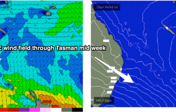
By Wednesday it looks like a classic La Niña map. Strong high just SE of Tasmania with a low in the Central Tasman directing a huge windfield through most of the Central to Northern Tasman Sea.
/reports/forecaster-notes/south-east-queensland-northern-new-south-wales/2022/07/01/small-clean-days
freeride76
Friday, 1 July 2022
By Wednesday it looks like a classic La Niña map. Strong high just SE of Tasmania with a low in the Central Tasman directing a huge windfield through most of the Central to Northern Tasman Sea.
/reports/forecaster-notes/south-east-queensland-northern-new-south-wales/2022/06/29/abating-energy
thermalben
Wednesday, 29 June 2022
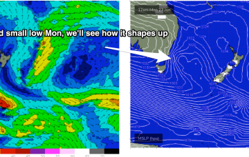
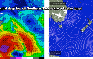
A complex trough spanning much of the East Coast will develop over the next few days, of which the latest model guidance is pointing towards a significant easterly trough low (that may become an ECL) slowly evolving from Saturday through the first half of next week.
/reports/forecaster-notes/south-east-queensland-northern-new-south-wales/2022/06/27/few-days-fun-s
freeride76
Monday, 27 June 2022
A potentially explosive pattern was mentioned last Mon, for the period leading into the first weekend of July and models are now firming on a strong coast hugging low moving south from the Coral Sea during this time frame. That portends plenty of wind, swell and potentially severe weather.

/reports/forecaster-notes/south-east-queensland-northern-new-south-wales/2022/06/24/temporarily-back
thermalben
Friday, 24 June 2022
During the morning, a low will form in the western Tasman Sea, driving gusty southerly winds along the Mid North Coast into the afternoon ahead of an overnight arrival into SE Qld.
/reports/forecaster-notes/south-east-queensland-northern-new-south-wales/2022/06/22/couple-days
freeride76
Wednesday, 22 June 2022
The tropical low over the North Island has rotated out of the swell window, dissipating quickly as it did so. We’ve still got some fun, albeit downgraded, E’ly quadrant swell inbound from that source before a period of quiet surf becomes established over the weekend.
/reports/forecaster-notes/south-east-queensland-northern-new-south-wales/2022/06/20/downgraded-notch
freeride76
Monday, 20 June 2022
As well as a precursor SE fetch adjacent to the South Island it is now squeezing pressure gradients with a compact, but deep low, which is currently forming gale force fetches out of Cook Strait and just north of the North Island. Compared to Fridays model runs the fetch now is a little more mobile, weaker and rotates faster out of the swell producing phase, which will see a bit of a downgrade. Still some good waves on offer though.
/reports/forecaster-notes/south-east-queensland-northern-new-south-wales/2022/06/17/active-tasman
thermalben
Friday, 17 June 2022
A broad region of troughiness stretching from the Tasman Sea through the Coral Sea over the weekend will coalesce into a major sub-tropical low off New Zealand’s North Island, on Monday.

/reports/forecaster-notes/south-east-queensland-northern-new-south-wales/2022/06/15/south-swell
freeride76
Wednesday, 15 June 2022
The Southern Ocean gyre is now well to the S and SE of the South Island, generating one last pulse of long period swell for our region. There’s a fresh set of cards to sort through next week with a couple of swell sources on offer. Read on for details.
