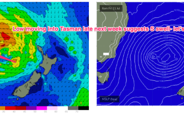
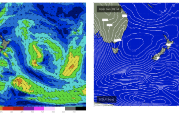
Low pressure formation looks likely, possibly a strong cut-off low moving into the Tasman Thurs and offering an initial spike in S swell Thurs before better angled S/SE swell into the weekend if the low hangs around in the south-east Tasman near the South Island.
Primary tabs
/reports/forecaster-notes/sydney-hunter-illawarra/2025/07/25/ne-windswell-short-term-uncertain
freeride76
Friday, 25 July 2025
/reports/forecaster-notes/sydney-hunter-illawarra/2025/07/23/ne-windswell-ahead-then-s-swells-medium
freeride76
Wednesday, 23 July 2025
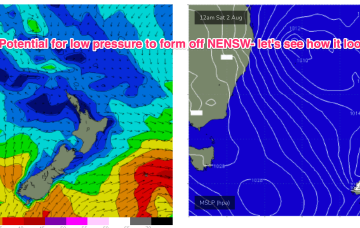
EC has a much more bullish outlook with a robust cut-off low sitting in the Tasman for the second half of next week.
/reports/forecaster-notes/sydney-hunter-illawarra/2025/07/21/downgraded-e-swell-still-offers-some-fun
freeride76
Monday, 21 July 2025
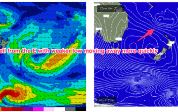
Unfortunately, compared to Fridays expectations the interplay between these two systems is weaker, with a more constrained fetch of lower windspeeds that drifts away quicker than modelled on Friday. That will result in smaller east quadrant swell this week, relative to Fridays expectations.
/reports/forecaster-notes/sydney-hunter-illawarra/2025/07/18/nice-run-ely-quadrant-swells-expected
freeride76
Friday, 18 July 2025
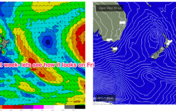
There’s still some model divergence later next week but for now we’ve got reasonable confidence a broad fetch will develop through the Northern Tasman as high pressure moves into the Tasman and supplies an anchor for the low.
/reports/forecaster-notes/sydney-hunter-illawarra/2025/07/16/flukey-swell-sources-the-s-short-term
freeride76
Wednesday, 16 July 2025
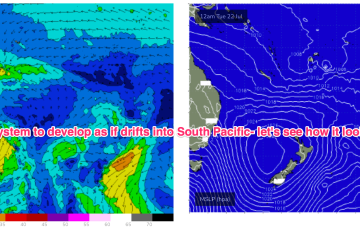
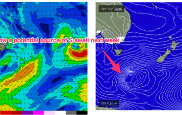
Not much short term gain from this system but there is broad model agreement we’ll see this low deepen and develop into a more powerful system mid/late next week as it drifts into a position north of the North Island.
/reports/forecaster-notes/sydney-hunter-illawarra/2025/07/14/more-southerly-energy-inbound
thermalben
Monday, 14 July 2025
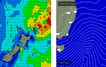
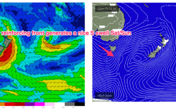
A strong front pushed into off the NSW coast the Tasman Sea overnight, and it’s generating a strong flush of south swell that’ll fill in this evening and provide a nice boost in surf size across Southern NSW.
/reports/forecaster-notes/sydney-hunter-illawarra/2025/07/10/lovely-s-swell-weekend-typical-winter
freeride76
Friday, 11 July 2025
We’ll see some nice strong S pulses over the weekend as multiple fetches operate on an active sea state. Nothing huge but of winter calibre.
/reports/forecaster-notes/sydney-hunter-illawarra/2025/07/08/upgraded-s-swell-outlook-the-weekend
freeride76
Wednesday, 9 July 2025
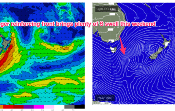
Compared to Mondays notes the outlook for S swell is improved, mostly due to a better aligned following front which conjoins the initial front and forms a slower moving low in the southern Tasman.
/reports/forecaster-notes/sydney-hunter-illawarra/2025/07/07/wly-pattern-not-much-surf-until-fri
freeride76
Monday, 7 July 2025
High pressure is well up over the centre of the continent with as weak, troughy area of low pressure moving offshore from the south coast dragging a cloud band with it and offering a W’ly flow in it’s wake. That W’ly flow looks to continue through the working week as a series of cold fronts sweep across the SE of the country.
/reports/forecaster-notes/sydney-hunter-illawarra/2025/07/03/fun-easing-swells-over-the-weekend-not
freeride76
Friday, 4 July 2025
The complex, coastal low is now dissipating and drifting towards New Zealand while high pressure drifts NE to sit over sub-tropical NSW/SEQLD tomorrow before entering the Tasman on Sunday with a broad low pushing across the interior of Victoria and NSW behind it.