The models have shunted the next frontal sequence a little further to the west. As such, even though it’ll be much stronger, the primary fetch will be bisected by Tasmania (see chart below) and this has slightly tempered surf height and duration estimates. More in the Forecaster Notes.
Primary tabs
/reports/forecaster-notes/sydney-hunter-illawarra/2019/07/12/lotsa-swell-out-south
thermalben
Friday, 12 July 2019
/reports/forecaster-notes/sydney-hunter-illawarra/2019/07/10/temporarily-small-surf-then-sizeable
thermalben
Wednesday, 10 July 2019
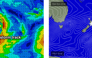
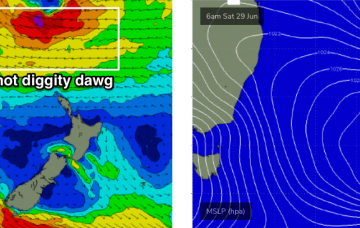
A stronger cold front will push into the lower Tasman Sea later Sunday, and a long fetch trailing behind will generate an extended period of large S’ly groundswell for Southern NSW. More in the Forecaster Notes.

/reports/forecaster-notes/sydney-hunter-illawarra/2019/07/08/mix-swells-next-few-days-then-strong-out
thermalben
Monday, 8 July 2019
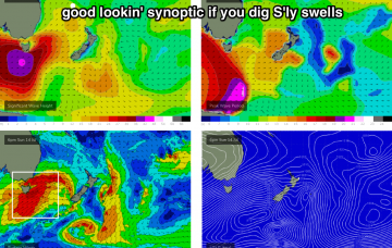
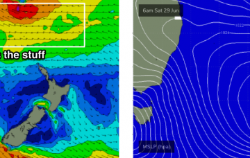
Our long run of E/NE swell - which kicked off last weekend - will slowly fade over the next few days, however the main feature on the forecast this week is an intense polar low that developed well SW of New Zealand over the weekend. More in the Forecaster Notes.
/reports/forecaster-notes/sydney-hunter-illawarra/2019/07/05/easing-east-building-south
thermalben
Friday, 5 July 2019
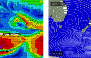
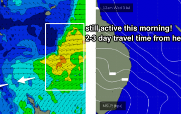
We have a really nice S/SE groundswell on the way, generated by an intense polar low developing off the ice shelf SW of New Zealand over the weekend. More in the Forecaster Notes.
/reports/forecaster-notes/sydney-hunter-illawarra/2019/07/03/stacks-swell-iffy-winds-abound
thermalben
Wednesday, 3 July 2019
Predominantly onshore winds are expected for the rest of the week, which will keep surface conditions a little below par. This is a shame as we’ve still got plenty of swell on the way. More in the Forecaster Notes.
/reports/forecaster-notes/sydney-hunter-illawarra/2019/07/01/make-most-tuesday
thermalben
Monday, 1 July 2019
From a forecasting perspective, we’re currently sitting at an awkward phase of the swell cycle. More in the Forecaster Notes.

/reports/forecaster-notes/sydney-hunter-illawarra/2019/06/28/week-filthy-waves
thermalben
Friday, 28 June 2019
Normally, large swell events identified a long time away usually downgrade over time. Fortunately, this event for next week has maintained its strength, in fact we’ve seen small upgrades from forecast to forecast, which is very encouraging. More in the Forecaster Notes.
/reports/forecaster-notes/sydney-hunter-illawarra/2019/06/26/put-diary-aside-next-week-will-ya
thermalben
Wednesday, 26 June 2019
There’s no major surf expected for the next few days. However, it won’t go flat either. Next week though.... More in the Forecaster Notes.
/reports/forecaster-notes/sydney-hunter-illawarra/2019/06/24/wide-range-swells-way
thermalben
Monday, 24 June 2019
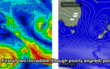
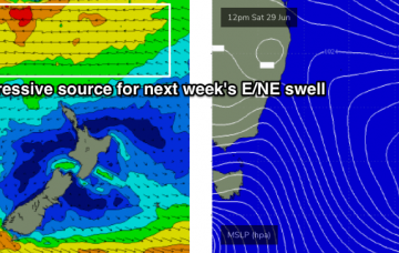
We’ve got two swell sources for the next few days. And an unreal E/NE groundswell lining up for next week. More in the Forecaster Notes.
/reports/forecaster-notes/sydney-hunter-illawarra/2019/06/21/stacks-energy-outta-south
thermalben
Friday, 21 June 2019
Looks like a windy couple of days ahead, thanks to a strong ridge of high pressure over the eastern states, maintaining a fresh southerly airstream throughout much of the NSW coast. More in the Forecaster Notes.